
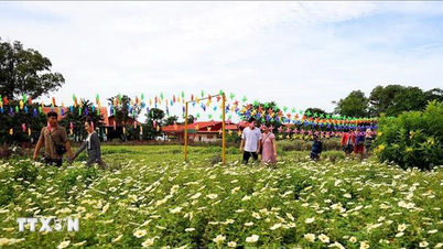
At around 4:00 p.m. on September 27, when storm Bualoi (storm number 10) was approaching land, the weather in Sam Son ward, Thanh Hoa province was still hot and sunny.
According to records at Sam Son beaches, although the waves were higher than usual, some tourists still went swimming. On the sand, many people participated in fun activities and team building.

Many tourists swim at Sam Son beach on the afternoon of September 27 (Photo: Thanh Tung).
To ensure the safety of residents and tourists, rescue forces are on duty at the beach, regularly reminding people to limit swimming.
According to the leader of the People's Committee of Sam Son ward, implementing the sea ban to respond to storm Bualoi (storm No. 10), the local government has deployed plans to support people to bring their boats ashore and anchor safely.
The leader also said that on September 28, the locality will ban all recreational activities and swimming.
Previously, the Chairman of Thanh Hoa Provincial People's Committee issued an urgent dispatch, requesting localities to postpone unnecessary meetings; mobilize the entire political system to focus on directing and urging storm response work.

A group of tourists playing games at Sam Son beach (Photo: Thanh Tung).
Localities are required to proactively evacuate people from dangerous areas, especially those at risk of being directly affected by storms, rising waters, landslides, flash floods and inundation, ensuring that people are brought to safety; ensuring adequate living conditions in evacuation areas; and absolutely not letting people go hungry or cold.
In mountainous communes, authorities urgently organized the evacuation of people from dangerous spots, vulnerable areas, and areas at high risk of landslides, flash floods, and inundation, in accordance with the evacuation plan that had been developed and approved; to be completed before 5 p.m. on September 28.

Lifeguards are on duty at the beach to remind people to limit swimming (Photo: Thanh Tung).
Thanh Hoa province has also issued a ban on going to sea across the entire area, starting from 6am on September 27 and lasting until the storm is over. In addition, the Department of Education and Training of Thanh Hoa province has decided to let students across the province take a day off on September 29 (Monday).
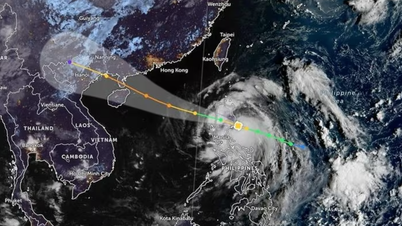
The National Center for Hydro-Meteorological Forecasting said that at 1 p.m. on September 27, storm No. 10 was about 270 km east-southeast of Hoang Sa special zone. The strongest wind in the storm's center was level 11-12 (103-133 km/h), gusting to level 15, moving in the West-Northwest direction, at a speed of about 30-35 km/h.
At 1 p.m. on September 28, the storm was in the Quang Tri - Da Nang sea area, about 180km east of Quang Tri. The strongest wind in the storm center was level 12-13, gusting to level 16.
In the next 12 hours, the storm will move mainly in the West-Northwest direction, at about 30km/h per hour and is likely to strengthen.
At 1:00 a.m. on September 29, storm Bualoi was on land in the Nghe An - Quang Tri area with intensity of level 10-11, gusting to level 14.
The storm then moved mainly in the West Northwest direction, traveling 20-25km per hour and weakened into a tropical depression and then a low pressure area.
The meteorological agency warned that this is a very fast-moving storm with strong intensity and a wide range of influence, which can cause a combination of many types of natural disasters such as strong winds, heavy rains, flash floods, landslides and coastal flooding.
Due to the influence of storm Bualoi, the North and Central East Sea (including Hoang Sa special zone) has strong winds of level 8-9, the area near the storm's eye has winds of level 10-13, gusts of level 16, waves 6-8m high, the area near the storm's eye has waves of 8-10m, and the sea is very rough.
From the evening of September 27, the sea area from Thanh Hoa to Quang Ngai (including Hon Ngu island, Con Co special zone and Ly Son) will have winds gradually increasing to level 6-7, gusting to level 8-9, waves 3-5m high, and rough seas.
From early morning on September 28, the wind increased to level 8-9, the area near the storm center passed level 10-13, gusting to level 16, waves 5-7m high, rough seas
Forecast from the afternoon of September 28, on land from Thanh Hoa to Northern Quang Tri, winds will gradually increase to level 6-7, then increase to level 8-9, near the storm center, level 10-12, gusting to level 14.
Coastal areas from Quang Ninh to Ninh Binh, from South Quang Tri to Hue, winds gradually increase to level 6-7, gusting to level 8-9.
From the night of September 27 to September 30, in the North and the area from Thanh Hoa to Hue, there is a possibility of widespread heavy rain with total rainfall of 100-300mm, locally over 400mm.
In the Northern Delta region and from Thanh Hoa to Ha Tinh, rain is generally 200-400mm, locally over 600mm.
Source: https://dantri.com.vn/du-lich/du-khach-tam-bien-sam-son-truoc-gio-bao-bualoi-do-bo-dat-lien-20250927163845722.htm
![[Photo] Prime Minister Pham Minh Chinh chairs the Government's online conference with localities](https://vphoto.vietnam.vn/thumb/1200x675/vietnam/resource/IMAGE/2025/10/5/264793cfb4404c63a701d235ff43e1bd)

![[Photo] Prime Minister Pham Minh Chinh launched a peak emulation campaign to achieve achievements in celebration of the 14th National Party Congress](https://vphoto.vietnam.vn/thumb/1200x675/vietnam/resource/IMAGE/2025/10/5/8869ec5cdbc740f58fbf2ae73f065076)


![[VIDEO] Summary of Petrovietnam's 50th Anniversary Ceremony](https://vphoto.vietnam.vn/thumb/402x226/vietnam/resource/IMAGE/2025/10/4/abe133bdb8114793a16d4fe3e5bd0f12)

![[VIDEO] GENERAL SECRETARY TO LAM AWARDS PETROVIETNAM 8 GOLDEN WORDS: "PIONEER - EXCELLENT - SUSTAINABLE - GLOBAL"](https://vphoto.vietnam.vn/thumb/402x226/vietnam/resource/IMAGE/2025/7/23/c2fdb48863e846cfa9fb8e6ea9cf44e7)


Comment (0)