
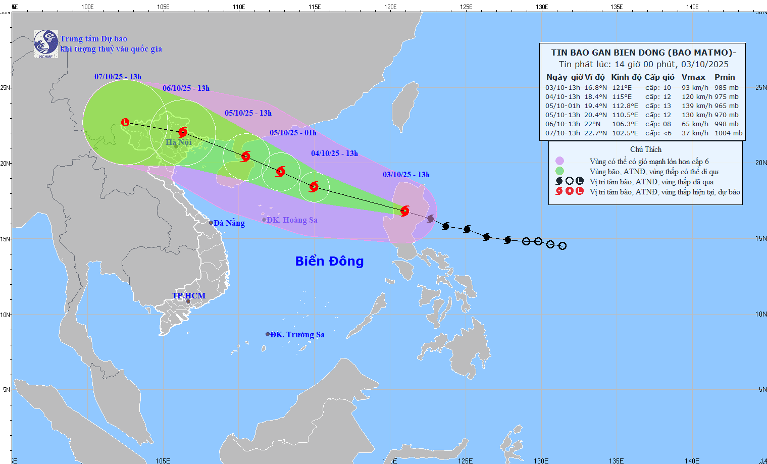
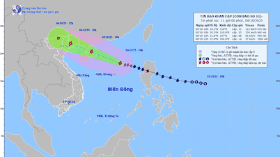
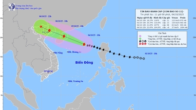
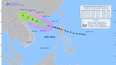
According to the National Center for Hydro-Meteorological Forecasting, at 1:00 p.m. on October 3, the center of the storm was located at about 16.8 degrees North latitude; 121.0 degrees East longitude, on the mainland north of Luzon Island (Philippines). The strongest wind near the center of the storm was level 9 - 10 (75 - 102 km/h), gusting to level 13. The storm moved in a West-Northwest direction at a speed of about 25 km/h.
According to international forecasts, at noon on October 3 in the East Sea, the forecasts of the International Storm Forecast Centers are relatively consistent, predicting that on the afternoon of October 3, storm MATMO will move into the East Sea, and on the afternoon and night of October 5, it will pass through the area between Hainan Island and Leizhou Peninsula (China) to enter the North of the Gulf of Tonkin. The storm intensity when in the East of Leizhou Peninsula (China) is strong at level 12 - 13, when entering the Gulf of Tonkin, the storm intensity will decrease to level 10, then it is likely to move into the mainland of Quang Ninh province and gradually weaken.
Vietnam's forecast predicts that around the evening of October 3, storm MATMO will cross the northern area of Luzon Island (Philippines) into the East Sea and become the 11th storm in the East Sea in 2025. It is forecasted that after moving into the East Sea, it will encounter relatively favorable sea surface temperature conditions (about 29 degrees Celsius), and wind shear in the northern area of the East Sea (where the center of storm MATMO moves into) will be small, favorable for the development of the storm. Meanwhile, the subtropical high pressure, the shape that determines the speed of movement in the direction of storm MATMO, will strongly encroach to the West, causing storm MATMO to tend to strengthen and move quickly (average 25 - 30 km/h). The maximum intensity of the storm can reach level 12 - 13, gusting to level 14 - 15 when in the east of Leizhou Peninsula (China) (evening of October 4).
From the time the storm moves into the sea area of Guangdong province (China), the subtropical high pressure tongue tends to weaken, at this time there will be 2 scenarios for the movement of storm No. 11.
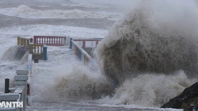
Scenario 1 (with a probability of about 70 - 75%) corresponds to the trend of the subtropical high pressure tongue weakening rapidly and retreating to the East, storm No. 11 will move more to the North, moving more over land (quite similar to the path of storm No. 9), so when reaching the northern area of Quang Ninh province, it will weaken by 2 - 4 levels compared to the time when the storm is strongest, with this scenario in the Gulf of Tonkin, strong winds of level 9 - 10, in the mainland of Quang Ninh - Hai Phong, strong winds of level 8 - 9, and heavy rain in the North (focusing on the midland and mountainous areas).
Scenario 2 is more extreme (with a probability of about 25 - 30%) when the subtropical high pressure weakens insignificantly, causing the storm to move mainly over the sea, so it weakens less than scenario 1. Therefore, the intensity of the storm when entering the Quang Ninh - Hai Phong area will be stronger than scenario 1, possibly causing strong winds of level 9 - 10 (gusts of level 12 - 14), the impact of strong winds will extend further south (Quang Ninh - Ninh Binh ), the rain will also be heavier, the strong wind area will also be deeper inland.
The storm's movement possibilities are also likely to change as the storm moves into the East Sea (then the scenarios will be clearer) so it is necessary to continuously update information on storm MATMO (storm number 11).
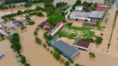
Forecast of heavy rain due to storm No. 11 (MATMO), from the night of October 5 to the end of the night of October 7, the Northern region and Thanh Hoa will have heavy to very heavy rain, with common rainfall of 100 - 200 mm, in some places over 300 mm; The mountainous and midland regions of the North will have common rain of 150 - 250 mm, locally over 400 mm.
From October 6 to 9, a flood occurred on rivers in the North, Thanh Hoa, and Nghe An; the flood peak was generally above alert level 2 to above alert level 3.
Source: https://baotintuc.vn/xa-hoi/hai-kich-ban-cua-bao-matmo-anh-huong-den-viet-nam-20251003170630687.htm

![[Photo] Solemn opening of the 8th Congress of the Central Public Security Party Committee, term 2025-2030](https://vphoto.vietnam.vn/thumb/1200x675/vietnam/resource/IMAGE/2025/10/4/f3b00fb779f44979809441a4dac5c7df)
![[Photo] General Secretary To Lam attends the 8th Congress of the Central Public Security Party Committee](https://vphoto.vietnam.vn/thumb/1200x675/vietnam/resource/IMAGE/2025/10/4/79fadf490f674dc483794f2d955f6045)


![[Photo] Students of Binh Minh Primary School enjoy the full moon festival, receiving the joys of childhood](https://vphoto.vietnam.vn/thumb/1200x675/vietnam/resource/IMAGE/2025/10/3/8cf8abef22fe4471be400a818912cb85)
![[Infographic] Notable numbers after 3 months of "reorganizing the country"](https://vphoto.vietnam.vn/thumb/1200x675/vietnam/resource/IMAGE/2025/10/4/ce8bb72c722348e09e942d04f0dd9729)


Comment (0)