
 |
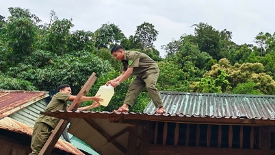
| Many households in Ngo Dao village, Da Phuc commune ( Hanoi ) were flooded more than 2 meters deep due to the rising Cau river. (Photo: Hoang Hieu/VNA) |
According to the National Center for Hydro-Meteorological Forecasting, the area from Quang Tri South to Hue, the South Central Coast and the Central Highlands and the South will continue to have rain, with some places experiencing heavy to very heavy rain.
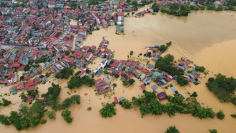
In Bac Ninh , floodwaters on the Cau River have peaked and are slowly receding. Many rivers remain above alert level 3 and continue to fall.
Specifically, the flood on Cau River (Bac Ninh) peaked at 7.52m (11pm on October 9), 1.22m above alert level 3 and slowly receding. The flood on Trung River (Lang Son) and Thuong River (Bac Ninh) continued to recede.
Water level at 1:00 a.m. on October 10 on Cau River at Dap Cau station was 7.52m, 1.22m above alarm level 3; on Thuong River at Cau Son station was 17.7m, 1.7m above alarm level 3; at Phu Lang Thuong station was 7.54m, 1.24m above alarm level 3, 0.01m above the historical flood in 1986 (7.53m).
On Trung River at Huu Lung station 22.11m, above alarm level 3 is 3.11m, below the historical level in 1986 (22.54m) by 0.43m.
In the next 12 hours, flood on Cau River at Dap Cau station will slowly recede and be above alert level 3; flood on Thuong River at Cau Son station and Phu Lang Thuong station, and on Trung River at Huu Lung station will continue to recede and be above alert level 3. In the next 12-24 hours, flood on rivers will continue to recede and remain above alert level 3.
Warning: In the next 24 hours, flood on Luc Nam River (Bac Ninh) at Luc Nam station, flood on Thai Binh River (Hai Phong) at Pha Lai station is decreasing and above alert level 1.
Due to the operation of the opening of 3 bottom spillways and the generation of electricity by Tuyen Quang Hydropower Plant, the water level on Gam River and Lo River (Tuyen Quang) will rise rapidly with a flood amplitude of 1-3m. During this flood, the peak water level on Gam River will be at and above alert level 2, and on Lo River will be below alert level 1.
Widespread flooding in Thai Nguyen, Bac Ninh, and Lang Son provinces will continue for the next 2-3 days; there is a risk of riverbank and dike erosion and landslides on steep slopes in the above areas. Flood risk warning level: Level 3.
Many areas still have rain
Last night and early this morning (October 10), in the area from South Quang Tri to Da Nang, Dak Lak, Lam Dong, Khanh Hoa and the South, there were scattered showers and thunderstorms, with heavy rain in some places.
Rainfall from 7pm on October 9 to 3am on October 10 was over 50mm in some places such as: Tien Ha station (Da Nang) 60mm, Dong Ban station (Tay Ninh) 54.6mm, La Nga station (Dong Nai) 51.4mm...
Forecast for the day and night of October 10, the area from South Quang Tri to Hue, the South Central Coast and the Central Highlands will have rain, moderate rain and scattered thunderstorms with rainfall from 15-40mm, locally heavy to very heavy rain over 80mm.
In the afternoon and evening of October 10, the Southern region will have scattered showers and thunderstorms, with some places experiencing heavy rain with rainfall ranging from 10-30mm, and some places experiencing heavy rain over 60mm. Warning of the risk of heavy rain (60mm/3 hours).
Thunderstorms may produce tornadoes, lightning, hail, and strong gusts of wind. Localized heavy rain may cause flash floods in small rivers and streams, landslides on steep slopes, and inundation in low-lying areas.
Thunderstorms and strong winds at sea
Currently (October 10), the low pressure trough has an axis at about 12-14 degrees North latitude connecting with a low pressure area located at 1:00-13.0 degrees North; 112.5-113.5 degrees South. The Central and Southern East Sea (including Truong Sa special zone), the sea area from South Quang Tri to Ca Mau, Ca Mau to An Giang and the Gulf of Thailand are experiencing showers and thunderstorms.
Forecast for the day and night of October 10, the North East Sea area (including Hoang Sa special zone), the Central and South East Sea area (including Truong Sa special zone), the sea area from South Quang Tri to Ca Mau, Ca Mau to An Giang and the Gulf of Thailand will have showers and thunderstorms.
During thunderstorms, there is a possibility of tornadoes, strong gusts of wind of level 6-7 and waves over 2m high. All vessels operating in the above areas are at risk of being affected by tornadoes and strong gusts of wind.
Specific weather in each region
The Northwest region is sunny during the day, with showers and thunderstorms at night in some places. The lowest temperature is from 22-25 degrees Celsius, in some places below 21 degrees Celsius; the highest temperature is from 30-33 degrees Celsius, in some places above 33 degrees Celsius.
The Northeast region is also sunny during the day, with showers at night in some places. The lowest temperature is from 22-25 degrees Celsius, in mountainous areas it is below 22 degrees Celsius; the highest temperature is from 30-33 degrees Celsius, in some places it is above 33 degrees Celsius.
From Thanh Hoa to Hue, the North is cloudy with scattered showers and thunderstorms; the South (South Quang Tri to Hue) is cloudy with rain, moderate rain and scattered thunderstorms, locally heavy to very heavy rain. During thunderstorms, there is a possibility of tornadoes, lightning and strong gusts of wind. The lowest temperature is from 23-26 degrees Celsius, the highest is from 29-32 degrees Celsius.
The South Central Coast has rain, moderate rain and scattered thunderstorms, locally heavy to very heavy rain. Northeast to East wind level 2-3. During thunderstorms, there is a possibility of tornadoes, lightning and strong gusts of wind. The lowest temperature is from 23-26 degrees Celsius, the highest is from 28-31 degrees Celsius.
The Central Highlands has scattered showers and thunderstorms; in the afternoon and evening there will be rain, moderate rain and scattered thunderstorms, locally heavy to very heavy rain. Light wind. During thunderstorms there is a possibility of tornadoes, lightning and strong gusts of wind. The lowest temperature is from 19-22 degrees Celsius, the highest is from 27-30 degrees Celsius.
The South has scattered showers and thunderstorms; in the afternoon and evening there will be scattered showers and thunderstorms, with some heavy rain in some places. West to Southwest wind level 2-3. During thunderstorms there is a possibility of tornadoes, lightning and strong gusts of wind. The lowest temperature is from 23-26 degrees Celsius, the highest is from 29-32 degrees Celsius.
Hanoi sunny day, some showers at night. Lowest temperature from 24-26 degrees Celsius, highest from 31-33 degrees Celsius.
Ho Chi Minh City has scattered showers and thunderstorms; in the late afternoon and evening there will be scattered showers and thunderstorms, with some heavy rain in some places. West to Southwest wind level 2-3. During thunderstorms there is a possibility of tornadoes, lightning and strong gusts of wind. The lowest temperature is from 24-26 degrees Celsius, the highest is from 30-32 degrees Celsius./.
Source: https://huengaynay.vn/chinh-tri-xa-hoi/theo-dong-thoi-su/nhieu-song-o-bac-bo-van-vuot-bao-dong-3-nguy-co-sat-lo-va-ngap-ung-keo-dai-158654.html


![[Photo] Unique Phu Gia horse hat weaving craft](https://vphoto.vietnam.vn/thumb/1200x675/vietnam/resource/IMAGE/2025/10/10/1760084018320_ndo_br_01-jpg.webp)
![[Photo] Prime Minister Pham Minh Chinh attends the Patriotic Emulation Congress of Hanoi city](https://vphoto.vietnam.vn/thumb/1200x675/vietnam/resource/IMAGE/2025/10/10/1760078918257_dsc-2008-jpg.webp)
![[Photo] Standing member of the Secretariat Tran Cam Tu works with the Standing Committee of the Party Committee of the Ministry of Health](https://vphoto.vietnam.vn/thumb/1200x675/vietnam/resource/IMAGE/2025/10/10/1760079818773_image-4-6972-jpg.webp)
![[Photo] "Exposing letters" in the flood center of Lang Son](https://vphoto.vietnam.vn/thumb/1200x675/vietnam/resource/IMAGE/2025/10/10/1760080117518_ndo_br_z7101324112737-07cd4d1c01801a8ccf4ae0cbaf31c4a3-507-jpg.webp)


![[Photo] President Luong Cuong presents decisions on conferring titles and appointing Vietnamese Ambassadors](https://vphoto.vietnam.vn/thumb/402x226/vietnam/resource/IMAGE/2025/10/10/1760082105623_image-1.jpeg)


Comment (0)