
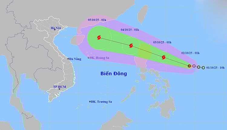
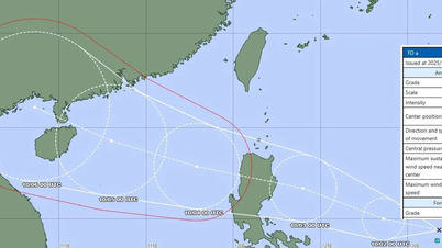
It is forecasted that by 1:00 a.m. on October 3, the center of the tropical depression will be at about 16.3 degrees North latitude; 124.6 degrees East longitude, in the sea east of Luzon Island (Philippines). The strongest wind near the center of the tropical depression will increase to level 8, gusting to level 10 and is likely to strengthen into a storm. By 1:00 a.m. on October 4, the tropical depression is likely to enter the East Sea, becoming a new storm with a strong intensity of level 10, gusting to level 12, continuing to move in a West-Northwest direction at a speed of about 25km/hour.
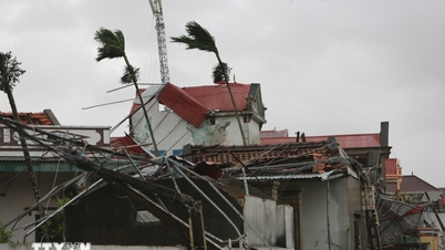
From the afternoon of October 3, the sea area east of the North East Sea has gradually increased to level 6-7, then increased to level 8; the area near the storm center has strong winds of level 9-10, gusting to level 12. Waves are 4-6m high, the sea is very rough, posing a potential risk to the safety of ships operating in the area.
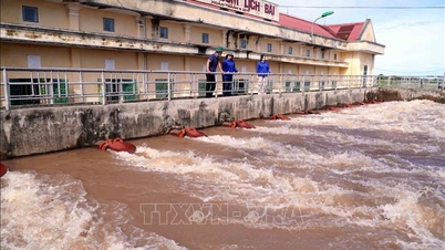
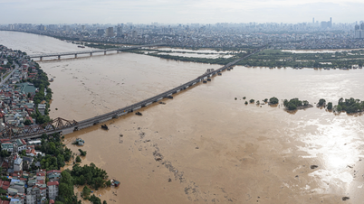
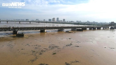
Meanwhile, the flood situation on rivers in the Northern and North Central regions continues to be complicated. At 1:00 a.m. on October 2, the water level of the Lo River at Tuyen Quang station reached 26.29m, exceeding the alarm level 3 by 0.29m. Floods on the Cau River, Thuong River and Thai Binh River are also rising rapidly. In the next 6 hours, floods on the Lo River and Thuong River are likely to peak above alarm level 3; in the next 12 hours, floods on the Cau River will peak at alarm level 3, and on the Thai Binh River above alarm level 2; the downstream of the Ca River (Nghe An) will see little change, then gradually decrease but remain at a high level.
Flood risks have been warned in low-lying areas along rivers and urban areas in the North and from Thanh Hoa to Nghe An. The mountainous provinces of the North and North Central continue to face a high risk of flash floods and landslides due to heavy rains that have lasted for many days, causing soil and rocks to become saturated with water. Rising floods also seriously affect waterway traffic, aquaculture, agricultural production and people's lives.
Localities are advised to closely monitor the development of tropical depressions and floods; proactively prepare response plans to ensure safety for people, infrastructure and socio -economic activities.
Weather forecast for regions across the country:
Hanoi capital is cloudy, sunny during the day, no rain at night. Southeast wind level 2 - 3. Lowest temperature 24 - 26 degrees Celsius. Highest temperature 30 - 32 degrees Celsius.
The Northwestern provinces are cloudy with scattered showers and thunderstorms. Light winds. Lowest temperature 23 - 26 degrees Celsius, some places below 22 degrees Celsius. Highest temperature 29 - 32 degrees Celsius, some places above 32 degrees Celsius.
The Northeastern region is cloudy with scattered showers and thunderstorms; sunny during the day. Southeast wind level 2 - 3. Lowest temperature 23 - 26 degrees Celsius. Highest temperature 30 - 33 degrees Celsius.
Provinces from Thanh Hoa to Hue have clouds, scattered showers and thunderstorms; sunny days. Light wind. Lowest temperature 23 - 26 degrees Celsius. Highest temperature 30 - 33 degrees Celsius.
The South Central Coast region is cloudy with scattered showers and thunderstorms; in the South, there will be scattered showers and thunderstorms during the day. Light winds. During thunderstorms, there is a possibility of tornadoes, lightning, hail and strong gusts of wind. Lowest temperature 24 - 27 degrees Celsius. Highest temperature 30 - 33 degrees Celsius, some places above 33 degrees Celsius.
The Central Highlands is cloudy with scattered showers and thunderstorms; in the late afternoon and evening there will be scattered showers and thunderstorms. Light winds. Thunderstorms may include tornadoes, lightning, hail, and strong gusts of wind. Lowest temperature 21 - 24 degrees Celsius. Highest temperature 29 - 32 degrees Celsius.
The South is cloudy with scattered showers and thunderstorms, with scattered showers and thunderstorms in the afternoon and evening, and some places with heavy rain. Light wind. During thunderstorms, there is a possibility of tornadoes, lightning, hail, and strong gusts of wind. Lowest temperature 24 - 27 degrees Celsius. Highest temperature 29 - 32 degrees Celsius, some places above 32 degrees Celsius.
Ho Chi Minh City is cloudy with scattered showers and thunderstorms, especially in the late afternoon and evening. Light wind. Thunderstorms may include tornadoes, lightning, hail, and strong gusts of wind. Lowest temperature 24 - 26 degrees Celsius. Highest temperature 31 - 33 degrees Celsius.
Source: https://baotintuc.vn/xa-hoi/thoi-weather-ngay-210-ap-thap-nhiet-doi-kha-nang-manh-len-thanh-bao-lu-tren-cac-song-tiep-tuc-dang-cao-20251002060753837.htm


![[Photo] Keep your warehouse safe in all situations](https://vphoto.vietnam.vn/thumb/1200x675/vietnam/resource/IMAGE/2025/10/1/3eb4eceafe68497989865e7faa4e4d0e)


Comment (0)