
 |
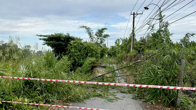
Heavy rain caused flood water to rise rapidly on Suoi Dai section across Pho Hoan bridge, Yen Bai city. Photo: Duc Tuyen. |
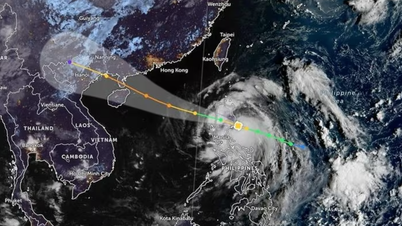
According to report No. 294/BC-SNNMT of the Department of Agriculture and Environment of Yen Bai province, due to the influence of the southern edge of the low pressure trough combined with converging winds, the areas in Yen Bai province last night and early this morning (June 25) in the west had scattered showers and thunderstorms, and in the east there was heavy to very heavy rain and thunderstorms.
As of 9am this morning, heavy rains caused landslides on the slopes of some households in Yen Binh district, 5 families in Tran Yen district were deeply flooded and had to be evacuated to other places. The floodwaters rose rapidly, affecting many households in Biec stream, Lieu Do commune, residential groups 12 and 13, Yen The town, Luc Yen district.
Heavy rain also caused flooding of 20 hectares of rice in Tran Yen district. The transportation system in Yen Bai was affected. In Luc Yen district, the water was deep and the slope was eroded, temporarily isolating Muong Lai commune. The rapid flood also affected provincial road 171, making it difficult to travel.
A series of landslides and local flooding on National Highway 70 include 2 landslides in Trung Tam commune - Luc Yen district, 5 landslides and 4 local flooding in Yen Binh district.
 |
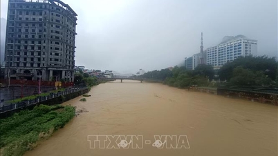
Localized flooding on National Highway 70 through Thinh Hung commune, Yen Binh district, Yen Bai province. Photo: Duc Tuyen. |
In Yen Bai city, there were 11 areas of local flooding, of which the deepest point was Le Van Tam street, about 1.2m deep. About 400 households were affected but they proactively moved their properties so there was no major damage.
Statistics from Yen Bai Hydrometeorological Station show that the rainfall measured from 7:00 p.m. on June 24 to 8:00 a.m. on June 25 in the east was generally from 50 - 100 mm, some places were higher than 250 mm such as Lieu Do 317 mm, Muong Lai 293 mm, Yen The 286 mm, Vinh Lac 257 mm.
The water level on Thao River at 7:00 a.m. on June 25 was 26.62 m, 3.38 m lower than Alarm Level 1; Ngoi Hut River and Nam Kim River changed slowly; Ngoi Thia River and Chay River fluctuated according to the regulation of upstream hydropower plants.
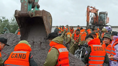
According to Mr. Nguyen Thai Binh - Deputy Director of the Department of Agriculture and Environment of Yen Bai province, after receiving notice of the impact of floods, the Steering Committee for Natural Disaster Prevention and Search and Rescue of districts and cities inspected and directed communes to arrange and assign teams to monitor areas at risk of landslides and floods to promptly respond. At the same time, localities maintained 24/24 duty to promptly notify and be ready to respond to ensure the safety of people's lives and property when situations arise.
Source: https://baophapluat.vn/yen-bai-5-ho-gia-dinh-phai-di-doi-do-mua-lon-post552942.html

![[Photo] Prime Minister Pham Minh Chinh chairs the Government's online conference with localities](https://vphoto.vietnam.vn/thumb/1200x675/vietnam/resource/IMAGE/2025/10/5/264793cfb4404c63a701d235ff43e1bd)


![[Photo] Prime Minister Pham Minh Chinh launched a peak emulation campaign to achieve achievements in celebration of the 14th National Party Congress](https://vphoto.vietnam.vn/thumb/1200x675/vietnam/resource/IMAGE/2025/10/5/8869ec5cdbc740f58fbf2ae73f065076)


![[Video] Jelly Mooncakes: New Colors for the Mid-Autumn Festival](https://vphoto.vietnam.vn/thumb/402x226/vietnam/resource/IMAGE/2025/10/5/abb1d390ee7f452b9110fca494ba0d77)


![[Video] Traditional moon cakes attract customers](https://vphoto.vietnam.vn/thumb/402x226/vietnam/resource/IMAGE/2025/10/5/0a98992e8c92419fa9ea507de23e365d)


![[VIDEO] Summary of Petrovietnam's 50th Anniversary Ceremony](https://vphoto.vietnam.vn/thumb/402x226/vietnam/resource/IMAGE/2025/10/4/abe133bdb8114793a16d4fe3e5bd0f12)

![[VIDEO] GENERAL SECRETARY TO LAM AWARDS PETROVIETNAM 8 GOLDEN WORDS: "PIONEER - EXCELLENT - SUSTAINABLE - GLOBAL"](https://vphoto.vietnam.vn/thumb/402x226/vietnam/resource/IMAGE/2025/7/23/c2fdb48863e846cfa9fb8e6ea9cf44e7)


Comment (0)