

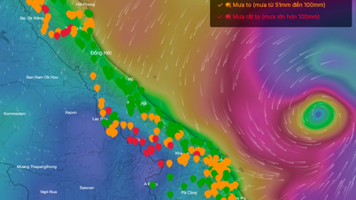
At 7:00 a.m. on September 28, the center of storm No. 10 was at about 16.6 degrees north latitude, 109.5 degrees east longitude, on the Quang Tri - Da Nang sea area, about 170km east of Hue city, with the strongest wind near the center of the storm at level 12 (118 - 133km/h), gusting to level 15.
Storm No. 10 is moving west-northwest at a speed of 30km/h. At 7:00 p.m. on September 28, the center of the storm was at about 18 degrees north latitude, 107.1 degrees east longitude, over the sea of Nghe An - Quang Tri with the strongest wind at level 12-13, gusting to level 16.
The storm continues to move rapidly in a west-northwest direction and make landfall in the Central provinces.

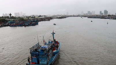
Due to the influence of the storm, the sea area from Thanh Hoa to Quang Ngai (including Hon Ngu island, Con Co special zone and Ly Son) has strong winds of level 6-7, then increasing to level 8-9, the area near the storm's center has level 10-13, gusting to level 16, waves from 5-7m high, and very rough seas.
Coastal areas and islands from Hung Yen - Ha Tinh have storm surges of 0.5-1.5m, especially in southern Thanh Hoa and Nghe An where they are 1-1.5m high. There is a high risk of flooding in low-lying areas, coastal roads, and river mouths due to storm surges and waves on the night of September 28 and the morning of September 29.
Coastal areas and islands from Ninh Binh to Ha Tinh have storm surges of 0.5-1.5m, especially from south Thanh Hoa to north Ha Tinh where they are 1-1.5m high. The risk of flooding dykes, coastal roads, and river mouths due to storm surges and waves is very high on the evening and night of September 28.

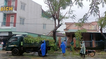
On land from southern Quang Tri to Da Nang, there are strong winds of level 6-7, gusting to level 8-9.
From noon on September 28, on land from Thanh Hoa to northern Quang Tri, winds gradually increased to level 6-7, then increased to level 8-9, near the storm center level 10-12, gusting to level 14.
From the afternoon of September 28, coastal areas from Quang Ninh to Ninh Binh will have strong winds of level 6-7, gusting to level 8-9.
From September 28 to September 30, in the North and the area from Thanh Hoa to Quang Ngai, there is a possibility of widespread heavy rain with total rainfall ranging from 100 - 300mm, locally over 450mm.
In the Northern Delta region, southern Phu Tho and from Thanh Hoa to northern Quang Tri, rainfall is generally from 200 - 400mm, locally over 600mm. Warning of the risk of rain with intensity greater than 200mm in 3 hours.
Source: https://baodanang.vn/anh-huong-hoan-luu-bao-so-10-da-nang-co-gio-manh-cap-6-7-giat-cap-8-9-3304868.html


![[Photo] Soldiers guard the fire and protect the forest](https://vphoto.vietnam.vn/thumb/1200x675/vietnam/resource/IMAGE/2025/9/27/7cab6a2afcf543558a98f4d87e9aaf95)


Comment (0)