
According to Mr. Mai Van Khiem, Director of the National Center for Hydro-Meteorological Forecasting, due to the influence of storm No. 11, since the morning of October 6, there has been moderate to heavy rain over a wide area in the Northern region.
From early morning and morning of October 7, due to the influence of the weakened low pressure circulation from storm No. 11 with the center of the low pressure area located in the western region of the North, combined with the Southeast wind zone of the subtropical high pressure tongue strongly encroaching from the East, creating a convergence zone of meridional winds in the northeastern region, running along the provinces of Tuyen Quang, Cao Bang, Thai Nguyen, Phu Tho, Hanoi , Lang Son, Bac Ninh.
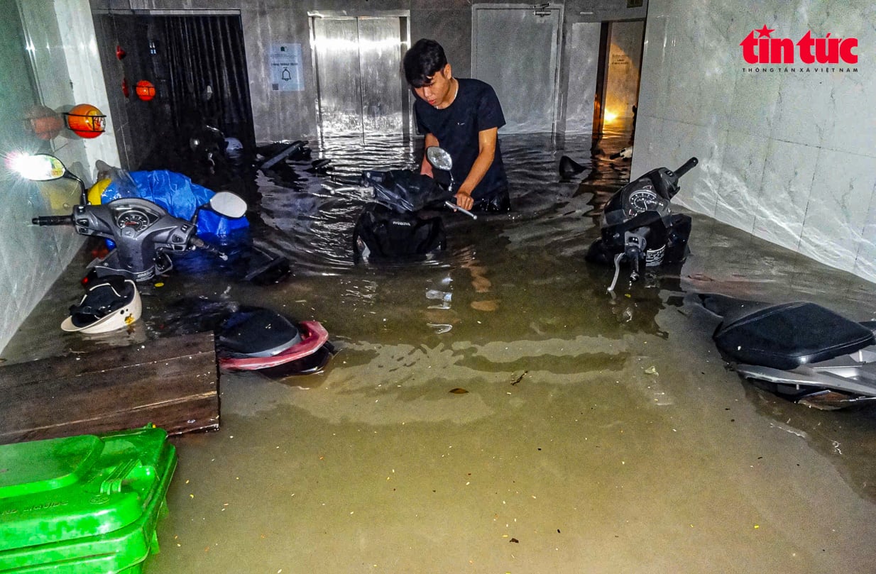
In particular, Thai Nguyen and Hanoi are the two provinces with particularly heavy rain. In Thai Nguyen, the rainfall from 7 p.m. on October 6 to 9 a.m. on October 7 was over 450 mm in some places, such as Hoa Thuong station (Thai Nguyen) 526 mm, Cay Thi station (Thai Nguyen) 462 mm, in other localities, there were places over 200 mm, such as Bo Ha station ( Bac Ninh ) 348 mm, Me Tri station (Hanoi) 261.6 mm, Soc Son station (Hanoi) 242.4 mm, Tan Tri 1 station (Lang Son) 224.4 mm, Chuc Bai Son station (Quang Ninh) 216 mm...
Comparing the two heavy rains in Hanoi (September 29-30, 2025 and October 6-7, 2025), Mr. Mai Van Khiem said that the common point of these two rains is the shape that causes heavy rain due to the convergence of meridional winds of the post-storm circulation and the humid Southeast wind zone of the subtropical high pressure. The heavy rain area in the Northern region, focusing on the Northeast region, including the capital Hanoi.
The difference is the time of rain: The rain on September 30th occurred from early morning and lasted until the afternoon; the rain on October 7th occurred mainly in the early morning and morning.
Regarding rainfall intensity: The largest 1-hour rainfall of the September 30 rain period measured at Dinh Cong station (Hanoi) from 11:00 to 12:00 on September 30 was 101.4 mm; the largest 1-hour rainfall of the October 7 rain period at Me Tri from 5:00 to 6:00 was 108.2 mm.
In terms of flooding, the rain on September 30 caused more widespread flooding than the rain on October 7. The heaviest rain of September 30 was concentrated in the inner city and the North of Hanoi, with rainfall ranging from 200 - 300 mm/24 hours; the West and Southwest (Ba Vi, Xuan Mai, Chuong My, Son Tay) had rainfall ranging from 60 - 90 mm. Meanwhile, the heaviest rain of October 7 was also concentrated in the inner city of Hanoi, including Me Tri, Lang, Cau Dien, Ha Dong, Phu Lam, Dong Anh. The areas of Ba Vi, Xuan Mai, Chuong My, Son Tay had light rain. The number of rain spots over 100 mm on September 30 was more than on October 7.
Mr. Mai Van Khiem forecasts that the current meridional wind convergence is showing signs of weakening, so in the afternoon of October 7, the North will still have moderate to heavy rain with rainfall in Tuyen Quang, Thai Nguyen , and Hanoi around 30 - 60 mm, locally over 100 m. In other places, it will rain from 20 - 30 mm; in the evening of October 7, the rain will decrease, but in the early morning, the Northeast region may have rain and moderate rain again.
Due to the impact of heavy rain from October 7 to October 10, floods on rivers in the Northern region and Thanh Hoa continued to rise. During this flood, the flood peak on rivers in Cao Bang, Lang Son, Quang Ninh provinces, Luc Nam River (Bac Ninh), Thai Binh River (Hai Phong) reached alert level 2, alert level 3 and above alert level 3; the flood peak on Thao River (Lao Cai), Lo River (Tuyen Quang), Hoang Long River (Ninh Binh), upstream Ma River (Thanh Hoa) reached alert level 1, alert level 2, some rivers above alert level 2; the flood peak reaching Hoa Binh Lake, downstream Red River at Hanoi station is likely to be above alert level 1.
Warning of widespread flooding in the provinces of Thai Nguyen, Bac Ninh, Lang Son, Cao Bang and risk of flooding in low-lying areas along rivers, urban areas in the Northern region and Thanh Hoa; risk of landslides on river banks, river dykes, risk of flash floods on rivers and streams and landslides on steep slopes in the mountainous areas of the Northern region and Thanh Hoa.
Source: https://baotintuc.vn/xa-hoi/bac-bo-tiep-tuc-mua-vua-mua-to-trong-chieu-710-20251007135131029.htm


![[Photo] Prime Minister Pham Minh Chinh chairs the 16th meeting of the National Steering Committee on combating illegal fishing.](https://vphoto.vietnam.vn/thumb/1200x675/vietnam/resource/IMAGE/2025/10/07/1759848378556_dsc-9253-jpg.webp)


![[Photo] Super harvest moon shines brightly on Mid-Autumn Festival night around the world](https://vphoto.vietnam.vn/thumb/1200x675/vietnam/resource/IMAGE/2025/10/07/1759816565798_1759814567021-jpg.webp)


Comment (0)