
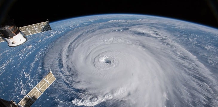
A group of American scientists has just published research results showing that the speed of expansion of storm size is closely related to sea temperature. Using a metaphor, they said that storms act like popcorn that pops faster in "hot spots" in the ocean - Photo: NASA
Tropical cyclones have long been considered a major threat to human life, not only because of their strong winds but also because of their size.
New research by scientists at Purdue University (USA) shows that hurricanes moving over warmer waters tend to expand more quickly. As a result, they cover a wider area, which means the area of strong winds, heavy rains and storm surges also spreads, increasing the risk of destruction.
Storms are getting bigger and more unusual
Professor Dan Chavas, of Purdue University's Department of Earth, Atmospheric and Planetary Sciences, likens the phenomenon to popcorn: "When you heat up a whole pan, the kernels can pop faster, but the hotter spots are where they pop the hardest and fastest. Hurricanes are the same: the warmer the water they pass over, the faster they expand."
This may explain why some storms in history have been devastating not only because of their wind strength but also because of their size. For example, Hurricane Helene in 2024 reached a diameter of more than 1,200 km with sustained winds of 225 km/h, causing severe flooding in the Appalachian Mountains.
Meanwhile, Hurricane Katrina in 2005 was only half the diameter but caused historic disaster in New Orleans due to rising water and broken levees. Before that, Hurricane Andrew in 1992 was only about 80km in diameter but extremely strong winds of up to 265km/h destroyed more than 63,000 houses in Florida.
Not only are hurricanes getting larger, they are also becoming more unpredictable in terms of their direction and speed. As the climate changes, atmospheric currents and ocean temperatures become more erratic, causing storm trajectories to fluctuate.
In fact, many storms in recent years have changed direction unexpectedly right before making landfall, causing great difficulties for local prevention and response work.
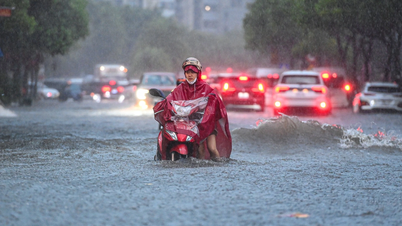
In the East Sea, where Vietnam is directly affected, recent storms such as Noru (2022), Talim and Saola (2023) clearly show this trend.
In particular, storm Bualoi (storm number 10) moves quickly and in a rare complex manner, with a speed of up to 35km/h, nearly double the average speed of many storms.
When entering the North Central region, Bualoi caused very heavy rain, howling winds, ripped off roofs, uprooted trees, and threw cars into lakes. The abnormality in both speed and scope of Bualoi clearly showed the challenges that coastal countries face in the context of climate change.
Climate change "feeds" fierce storms
Some storms move very quickly, making landfall in just a few dozen hours; but others move slowly, changing direction erratically, making it challenging to predict their path.
This reality poses an urgent need to improve monitoring capacity, continuously update forecasts, and strengthen flexible response measures for coastal communities.
Climate change is seen as a driving factor in the increasing intensity of extreme weather events. Rising sea surface temperatures have "fueled" many storms around the world , according to the nonprofit Climate Central.
A study published in the journal Environmental Research: Climate 2024 found that from 2019 to 2023, most hurricanes were exacerbated by climate change, and all hurricanes that formed in 2024 were affected by this impact.
New findings from Purdue University not only help explain differences in hurricane size, but also highlight the growing danger as the Earth warms.
As ocean waters continue to warm and hurricane trajectories become less predictable, more accurate tracking and forecasting of storm size and path will become key to minimizing damage to communities.
Source: https://tuoitre.vn/bao-bualoi-canh-giac-cao-voi-nhung-con-bao-du-bat-thuong-20250929165910123.htm
![[Photo] Opening of the 13th Conference of the 13th Party Central Committee](https://vphoto.vietnam.vn/thumb/1200x675/vietnam/resource/IMAGE/2025/10/6/d4b269e6c4b64696af775925cb608560)


Comment (0)