
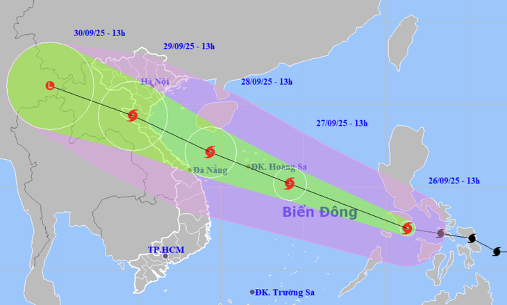
Forecast of location and direction of storm Bualoi - Photo: NCHMF
Mr. Mai Van Khiem, Director of the National Center for Hydro-Meteorological Forecasting, said this at a meeting to respond to storm Bualoi about to enter the East Sea, organized by the Ministry of Agriculture and Environment on the afternoon of September 26.
Storm Bualoi is forecast to make landfall in our country on September 29.
According to Mr. Khiem, at 1 p.m. on September 26, the center of storm Bualoi (named after a type of tea from Thailand) was sweeping through the central region of the Philippines. The storm is currently at level 11 (103-117 km/h), gusting to level 14.
It is forecasted that in the next 5-7 hours (evening of September 26), storm Bualoi will enter the East Sea and become storm number 10 in 2025.
Regarding the next developments, Mr. Khiem said that storm Bualoi is affected by a number of factors. First, it is forecasted that after entering the East Sea, the storm's intensity will likely increase because the sea water temperature in the entire East Sea is currently at 28-29 degrees Celsius, the humidity is also very high, the wind shear is low and the upper level is also low (not enough conditions to dissipate the energy supplied to the storm).
"Unlike storm Ragasa (storm No. 9) which moved mostly over land, causing the storm to break down and weaken quickly, storm Bualoi moved completely over the sea before entering our country. At the same time, the storm was not affected by cold air, so it was difficult to weaken.
These are favorable factors for storm Bualoi to strengthen in the East Sea. Its maximum intensity could reach level 13, gusting to level 15, or even higher when it reaches the Hoang Sa archipelago," Mr. Khiem said, warning that the storm is likely to strengthen as it gets closer to shore.
Regarding the forecast of strong winds when making landfall, Mr. Khiem said that international and Vietnamese stations have not yet reached a consensus, some agencies forecast level 10-11, some forecast level 12-13. After the storm enters the East Sea, the storm will restructure and move stably, so the forecast will be more accurate.
Regarding the storm's path, according to Mr. Khiem, after entering the East Sea, the storm will move in a west-northwest direction. When the storm reaches the Hoang Sa archipelago, the subtropical high pressure is likely to move outward, causing the storm to tend to deviate northward, towards the North Central region, and even the Northern Delta.
"Regarding international forecasts, the forecasts for the afternoon of September 25 are still quite scattered. The agencies differ by 500-700km. There are plans for the storm to enter the Northern Delta. There are plans for it to enter Hue and Da Nang . There are plans for it to enter the Thanh Hoa - Ha Tinh region (North Central Coast).
However, by the morning of September 26, about 70-80% of forecasts predicted the storm would hit Ha Tinh , Nghe An, Thanh Hoa and the southern Northern Delta.
"When the storm enters the Hoang Sa archipelago, the meteorological agency will locate the area where the storm is most likely to make landfall," said Mr. Khiem. He said that the storm will make landfall on the mainland of our country around the morning of September 29. From September 28 to 29, the storm is likely to reach its maximum intensity.

Mr. Mai Van Khiem analyzes the developments of storm Bualoi - Photo: C. TUE
70-80% of storm Bualoi makes landfall in North Central Vietnam
Regarding the impact of the storm, Mr. Khiem said that in the northern area of the East Sea (Hoang Sa special zone), the central area of the East Sea has strong winds of level 6-7, then increasing to level 8-9, the area near the storm's center has winds of level 11-13, gusts of level 16, waves over 7-9m high, and rough seas.
The sea area south of Bac Bo Gulf, Quang Tri-Quang Ngai sea area, from the evening of September 27, has strong winds of level 6-7, then increasing to level 8-9, near the storm center level 10-13, gusting to level 15.
In the northern and central East Sea, waves are 6-8m high, near the storm center, waves are very large, 8-10m high. In the offshore areas of the southern Gulf of Tonkin and Quang Tri - Quang Ngai, waves are 3-5m high, near the storm center, waves are 5-7m high. In the coastal waters of Hung Yen - Quang Ngai provinces, waves are 3-5m high, near the storm center, waves are 4-6m high.
Therefore, from this moment on, it is necessary to notify ships to find safe shelter, especially ships operating in the northern and central areas of the East Sea, and the waters of the North Central and Central Central provinces.
"There are three possible landing scenarios. First, the storm follows the south of Hainan Island (China) and then moves up and makes landfall in the North, then the rain concentrates in the North.
Second scenario, if the storm goes straight to the Central Central region, heavy rain will be concentrated in the areas of Quang Tri, Hue, and Da Nang.
The third scenario with the highest probability (about 70-80%) is that the storm will enter the North Central region. With this scenario, heavy rain will concentrate from Quang Tri, Ha Tinh, Nghe An, Thanh Hoa and expand to the Northern Delta, possibly reaching the south of Phu Tho and Son La" - Mr. Khiem predicted.
Source: https://tuoitre.vn/bao-bualoi-kha-nang-cang-vao-gan-bo-cang-manh-co-3-kich-ban-do-bo-20250926152137644.htm


Comment (0)