
Warning: From now until 6 o'clock, convective clouds will continue to develop, causing showers and thunderstorms in the above areas, which may then spread to communes and wards across the province. During thunderstorms, beware of lightning, tornadoes, hail and strong gusts of wind; water flowing rapidly over spillways and spillways. Agencies, departments, branches and people are requested to pay attention to prevention and ensure safety.
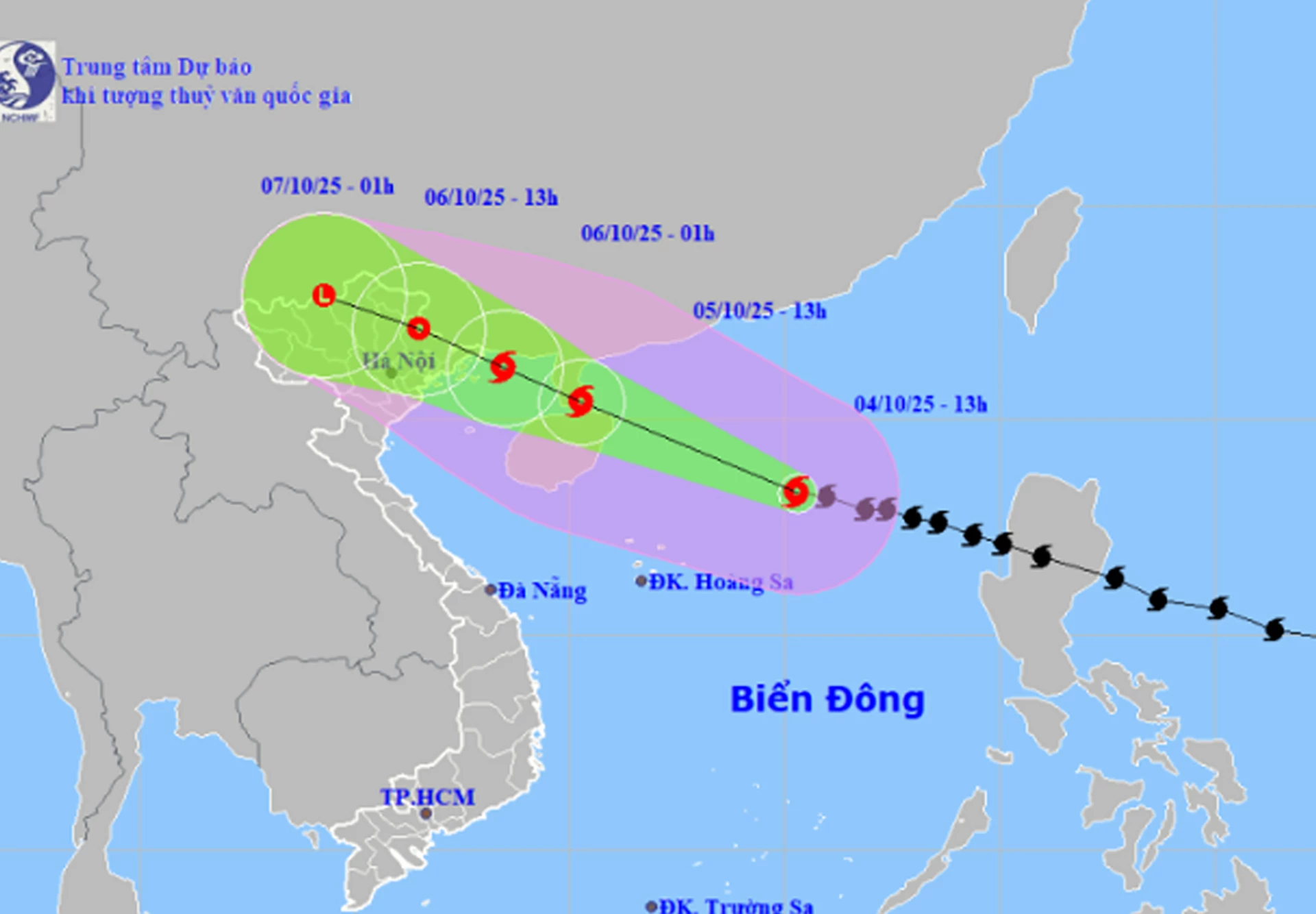 |
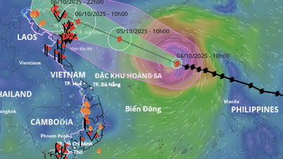
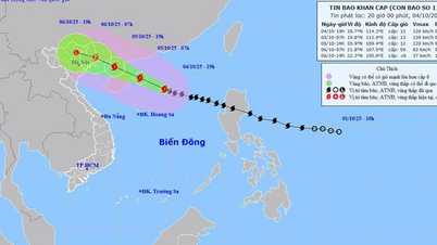
| Location and forecast direction of storm number 11. |
According to the news of the specialized agency, at 1:00 p.m. on October 4, storm No. 11 was located in the North East Sea, about 500 km east-southeast of Hainan Island (China). The strongest wind near the storm's center was level 11-12 (103-133 km/h), gusting to level 15, moving in the West Northwest direction, at a speed of about 25 km/h. It is forecasted that by 1:00 p.m. on October 5, storm No. 11 will be located in the sea east of Leizhou Peninsula (China), with wind force of level 12-13, gusting to level 16.
Due to the impact of the storm, the North East Sea area has strong winds of level 8-10, the area near the storm's eye has winds of level 11-13, gusts of level 16, waves 4-6m high, the area near the storm's eye is 6-8m, the sea is very rough, the destructive power is extremely large, the waves are extremely strong, sinking large ships.
It is forecasted that from the afternoon of October 5, the sea area east of the Northern Gulf of Tonkin (including Bach Long Vi special zone) will have winds gradually increasing to level 6-7, then increasing to level 8-9. From the evening of October 5, the northern Gulf of Tonkin (including Bach Long Vi special zone, Van Don, Co To, Cat Hai and Hon Dau island) will have winds gradually increasing to level 8-9, waves 2-4m high, the area near the storm center will have levels 10-11, gusts of level 14, waves 3-5m high, very rough seas, very dangerous for boats. The coastal areas and islands of Quang Ninh - Hai Phong province will have storm surges of 0.4-0.6m high, beware of flooding in low-lying coastal areas and river mouths due to surges and big waves from the afternoon and evening of October 5.
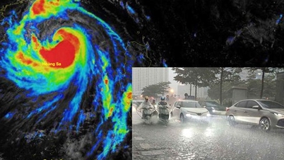
The specialized agency warns that the weather at sea and in coastal areas during the storm is extremely dangerous and unsafe for any vehicle or structure operating in the danger zone such as: tourist boats, passenger ships, transport ships, cages, rafts, aquaculture areas, dykes, embankments, coastal routes. Vehicles are at high risk of capsize, destruction, and flooding due to strong winds, big waves and rising sea levels.
On land, from the night of October 5, coastal areas from Quang Ninh to Hung Yen will see winds gradually increase to level 6-7, near the storm's eye level 8-9, gusting to level 10-11. This wind force is capable of breaking tree branches, blowing off roofs, causing damage to houses. Inland areas in the Northeast, winds will increase to level 4-5, in some places level 6, gusting to level 7-8.
From the night of October 5 to the end of the night of October 7, in the mountainous and midland areas of the North, there will be heavy rain, with average rainfall of 150-250mm, and locally very heavy rain over 400mm. Warning of the risk of heavy rain (>150mm/3 hours); in the Northern Delta and Thanh Hoa, there will be moderate to heavy rain with average rainfall of 70-150mm, and locally very heavy rain over 200mm. In the Hanoi area, it is forecasted that from early morning of October 6 to the end of October 7, there will be moderate to heavy rain, with average rainfall of 70-120mm, and locally over 150mm.
Due to the influence of the wide storm circulation, it is necessary to guard against the risk of thunderstorms, tornadoes and strong gusts of wind both before and during the storm's landfall.
H.D
Source: https://baokhanhhoa.vn/xa-hoi/202510/bao-giat-cap-16-tren-bien-dong-canh-bao-mua-lon-cuc-bo-tren-dia-ban-tinh-khanh-hoa-eb4648e/


![[Photo] Solemn opening of the 8th Congress of the Central Public Security Party Committee, term 2025-2030](https://vphoto.vietnam.vn/thumb/1200x675/vietnam/resource/IMAGE/2025/10/4/f3b00fb779f44979809441a4dac5c7df)
![[Photo] General Secretary To Lam attends the 8th Congress of the Central Public Security Party Committee](https://vphoto.vietnam.vn/thumb/1200x675/vietnam/resource/IMAGE/2025/10/4/79fadf490f674dc483794f2d955f6045)

![[Photo] Bustling Mid-Autumn Festival at the Museum of Ethnology](https://vphoto.vietnam.vn/thumb/1200x675/vietnam/resource/IMAGE/2025/10/4/da8d5927734d4ca58e3eced14bc435a3)


![[VIDEO] Summary of Petrovietnam's 50th Anniversary Ceremony](https://vphoto.vietnam.vn/thumb/402x226/vietnam/resource/IMAGE/2025/10/4/abe133bdb8114793a16d4fe3e5bd0f12)

![[VIDEO] GENERAL SECRETARY TO LAM AWARDS PETROVIETNAM 8 GOLDEN WORDS: "PIONEER - EXCELLENT - SUSTAINABLE - GLOBAL"](https://vphoto.vietnam.vn/thumb/402x226/vietnam/resource/IMAGE/2025/7/23/c2fdb48863e846cfa9fb8e6ea9cf44e7)


Comment (0)