
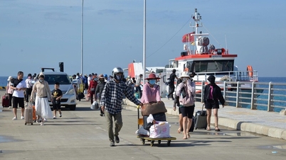
Experts recommend that fishermen and crew members regularly monitor weather forecasts on the media and storm warning signal systems...
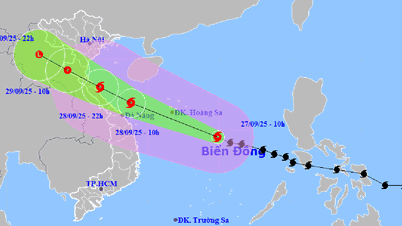
") Storm's path on the afternoon of October 5. (Photo: VNA)
Storm's path on the afternoon of October 5. (Photo: VNA)According to the National Center for Hydro-Meteorological Forecasting, on the afternoon of October 5, storm Koinu entered the northeastern sea of the North East Sea and became storm number 4 in 2023.
At 4:00 p.m., the center of storm No. 4 was at about 22 degrees North latitude; 119.7 degrees East longitude, about 370km East Southeast of Guangdong (China).
The strongest wind near the storm center is level 12 (118-133 km/h), gusting to level 15. The storm is moving west at a speed of about 10 km/h.
[Storm Koinu has strong winds of level 14, gusts of level 17, and rough seas]
At 4 p.m. on October 6, the storm was about 140 km southeast of Guangdong (China) and gradually weakening. The strongest wind was level 10, gusting to level 13.
As of 4 p.m. on October 7, the storm was moving westward at a speed of about 5-10 km/hour, in the sea southeast of Guangdong province (China). The strongest wind was level 8, gusting to level 11.
By 4 p.m. on October 8, the storm was moving west-southwest at a speed of about 5 km/hour and weakened into a tropical depression. The strongest wind was level 6, gusting to level 8.
From the next 72-96 hours, the tropical depression will move mainly in the West Southwest direction, traveling 5-10km per hour and weaken into a low pressure area.
Due to the influence of storm No. 4, the northeastern sea area of the North East Sea has strong winds of level 7-10, the area near the storm's eye has strong winds of level 11-12, gusting to level 15; the sea is very rough.
In the North East Sea, waves are 2-4m high, in the Northeast, waves are 4-6m high, and near the storm center, waves are 6-8m high.
According to the guidance of the Standing Office of the National Steering Committee for Natural Disaster Prevention and Control, in the face of strong winds and large waves in the northeastern sea area of the North East Sea, competent authorities need to notify vehicles and ships operating at sea of the above developments to proactively prevent, ensure safety and have appropriate production plans; maintain communication, prepare forces and means for rescue when there is a situation...
Experts recommend that fishermen and crew members regularly monitor weather forecasts on the media and storm warning signal systems...
On land, the National Center for Hydro-Meteorological Forecasting said that from 4:40 p.m. to 9:40 p.m. on October 5, the provinces of Binh Dinh, Phu Yen , Khanh Hoa, Kon Tum, and Dak Lak will continue to have rain with accumulated rainfall ranging from 20-40 mm, with some places over 70 mm.
There is a very high risk of flash floods on small rivers and streams, landslides on steep slopes in the above provinces, especially in the districts of Van Canh, Hoai An, Phu Cat (Binh Dinh province), Son Hoa (Phu Yen province), Khanh Vinh, Khanh Son, Van Ninh, Dien Khanh (Khanh Hoa province), Kon Plong, Tu Mo Rong, Dak Glei, Ngoc Hoi ( Kon Tum province), EaH'leo, M'Drak, Ea Kar, Krong Bong (Dak Lak province).
Warning level of natural disaster risk due to flash floods, landslides, land subsidence due to heavy rain or level 1 flow.
Flash floods and landslides can have very negative impacts on the environment, threaten people's lives; cause local traffic congestion, affect the movement of vehicles; destroy civil and economic works, causing damage to production and socio-economic activities.
Weather in the evening and night of October 5: The Northwest and Northeast regions will have scattered showers and thunderstorms at night, with the possibility of tornadoes, lightning, and strong gusts of wind. The lowest temperature in the Northwest is 22-25 degrees Celsius, in some places below 22 degrees Celsius. The lowest temperature in the Northeast is 24-27 degrees Celsius, in mountainous areas below 23 degrees Celsius.
Hanoi capital night no rain, light wind. Lowest temperature 25-27 degrees Celsius.
In the late afternoon and evening, the provinces from Thanh Hoa to Thua Thien-Hue will have scattered showers and thunderstorms. In the South, there will be scattered showers and thunderstorms in the late afternoon and evening. There is a possibility of tornadoes, lightning, and strong gusts of wind during thunderstorms. The lowest temperature is 24-27 degrees Celsius.
Provinces and cities from Da Nang to Binh Thuan have scattered showers and thunderstorms.
In the North, there will be scattered showers and thunderstorms, with the possibility of tornadoes, lightning, and strong gusts of wind. In the South, there will be southwest winds at level 2-3. Lowest temperature 24-27 degrees Celsius.
The Central Highlands and the South will have scattered showers and thunderstorms at night, with the possibility of tornadoes, lightning, and strong gusts of wind. Southwest wind level 2-3. The lowest temperature in the Central Highlands is 20-23 degrees Celsius. The lowest temperature in the South is 23-26 degrees Celsius./.
Source


![[Photo] Hanoi morning of October 1: Prolonged flooding, people wade to work](https://vphoto.vietnam.vn/thumb/1200x675/vietnam/resource/IMAGE/2025/10/1/189be28938e3493fa26b2938efa2059e)


![[Photo] Panorama of the cable-stayed bridge, the final bottleneck of the Ben Luc-Long Thanh expressway](https://vphoto.vietnam.vn/thumb/1200x675/vietnam/resource/IMAGE/2025/9/30/391fdf21025541d6b2f092e49a17243f)


Comment (0)