
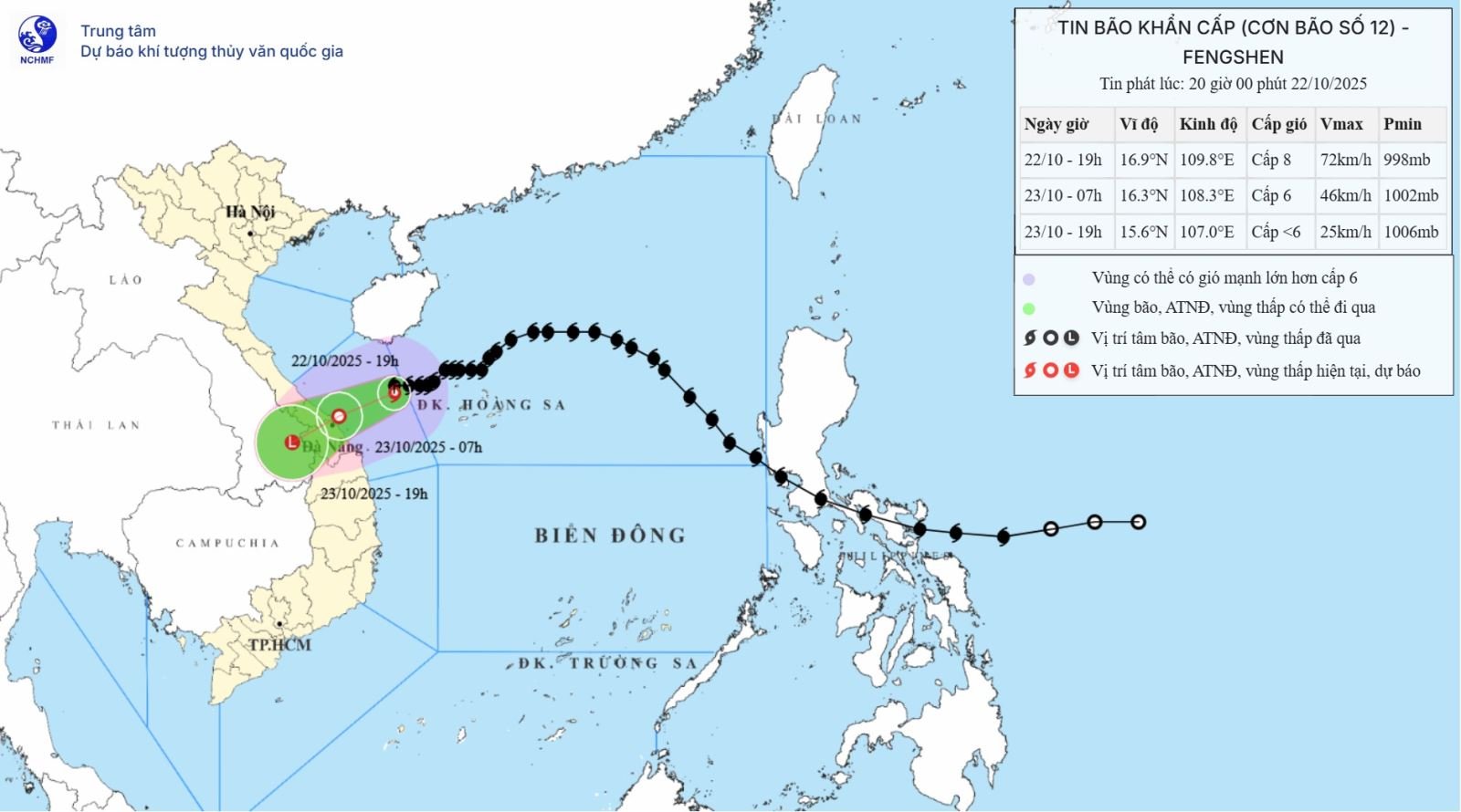
Accordingly, at 7 p.m., the center of the storm was at about 16.9 degrees North latitude; 109.8 degrees East longitude, on the sea from South Quang Tri to Quang Ngai, about 170km East Northeast of Da Nang City. The strongest wind near the center of the storm was level 8 (62-74km/h), gusting to level 10. Moving westward, speed about 10km/h.
Forecast until 7:00 a.m. on October 23, the storm in the coastal areas from Da Nang to Quang Ngai provinces and cities, with strong winds of level 6, gusts of level 9, moving in the West Southwest direction at a speed of about 10 km/h and gradually weakening. The affected area is the western sea area of the North East Sea (including Hoang Sa special zone), the sea area from Quang Tri to Quang Ngai (including the special zones of Con Co island, Ly Son and Cu Lao Cham island), the mainland coastal areas of provinces and cities from Quang Tri to Da Nang. Disaster risk level 3.
Then, at 7:00 p.m. on October 23, the storm in the southern Laos area, with winds below level 6, moved in the West Southwest direction at a speed of about 15 km/h and gradually weakened into a low pressure area. The affected area is the sea from Quang Tri to Quang Ngai (including the special zones of Con Co, Ly Son and Cu Lao Cham islands); the mainland coastal provinces and cities from Quang Tri to Da Nang.
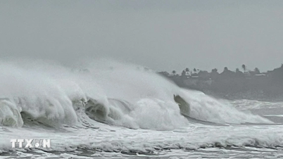
Due to the storm's influence, the western sea area of the North East Sea (including Hoang Sa special zone) has strong winds of level 6-7; the area near the storm's center has strong winds of level 8, gusting to level 10; waves 3-5m high, rough seas.
The sea area from Quang Tri to Quang Ngai (including Con Co special economic zone, Cu Lao Cham island and Ly Son special economic zone) has strong winds of level 6-7, gusts of level 9, waves 3-5m high, and rough seas.
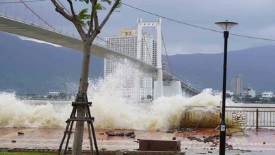
Coastal areas from Quang Tri Province to Da Nang City have storm surges of 0.4-0.8m high.
Warning: Coastal areas and river mouths from South Quang Tri to Da Nang City need to be on guard against large waves combined with high tides and storm surges causing flooding in low-lying areas, waves overflowing coastal roads and riverbanks, and coastal erosion. Be on guard against the risk of thunderstorms, tornadoes, and strong gusts of wind in the storm's circulation area, both before and during the storm's landfall.
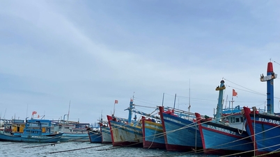
All ships, boats, and aquaculture areas in the above-mentioned dangerous areas are susceptible to the impact of storms, whirlwinds, strong winds, large waves, and rising sea levels.
On land: Due to the influence of storm circulation No. 12 combined with strong cold air, from the evening and night of October 22, on the mainland, coastal provinces and cities from Quang Tri to Da Nang, winds will gradually increase to level 5, in some places to level 6, gusting to level 8. Also due to the influence of storm circulation and cold air combined with East wind disturbances and terrain effects, from the night of October 22 to the night of October 24, in the area from Ha Tinh to Quang Ngai, there will be heavy rain and thunderstorms with common rainfall of 100-200mm, locally with very heavy rain over 300mm; in particular, the area from South Quang Tri to Da Nang city will have heavy to very heavy rain with common rainfall of 200-400mm, locally with over 700mm (heavy rain concentrated from the night of October 22 to the end of October 23).
Warning of risk of heavy rain over 150mm/3 hours in coastal communes/wards from South Quang Tri to Da Nang city.
Heavy rains in the Central region are likely to last until the end of October 2025. There is a high risk of flash floods and landslides in mountainous areas, and flooding in low-lying and urban areas.
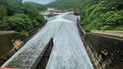
"Localities need to pay attention to safely operating hydroelectric and irrigation reservoirs before, during and after the storm, and prepare response plans for flood scenarios on rivers from South Quang Tri to Da Nang that could reach alert levels 2-3, with some places above alert level 3. Forecast level of natural disaster risk due to floods and inundation: level 2-3," Director of the National Center for Hydro-Meteorological Forecasting Mai Van Khiem noted.
According to the Ministry of Agriculture and Environment, storm No. 12 is complicated, with a high risk of heavy rain lasting for many days over a large area, causing major floods, deep inundation, flash floods, landslides in many localities. Therefore, ministries, branches and localities need to focus on responding according to the direction of the Prime Minister in Official Dispatch No. 200/CD-TTg dated October 20 on proactively implementing measures to respond to storm No. 12 and floods and Official Dispatch No. 202/CD-TTg dated October 22 on focusing on preventing, avoiding, and responding to floods, flash floods, landslides in the Central Central region.
To proactively respond to storm No. 12, the Ministry of Agriculture and Environment recommends that for coastal routes, ministries, branches and localities focus on using all measures to call and guide ships operating at sea to escape from dangerous areas or to safe shelters; organize and arrange for ships to anchor at safe shelters; evacuate people on boats, cages, watchtowers, and aquaculture areas to safe places; and take precautions against thunderstorms before and during the storm's landing.
Ministries, sectors and localities deploy measures to ensure safety for tourism and aquaculture activities at sea, in river mouths and along the coast; continue to maintain the sea ban for fishing boats, transport ships and tourist boats until weather conditions at sea ensure safety.
On land: Provinces and cities direct functional units to organize tree pruning, bracing, and reinforcing houses; prepare measures to ensure safety, limit damage to warehouses, headquarters, public works, industrial parks, factories, power grids, and telecommunications systems.
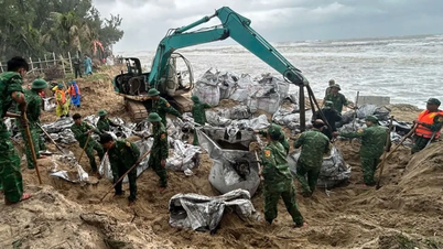
Provinces and cities should review areas at risk of flash floods, landslides, and deep flooding, especially households and residential areas living in mountainous areas, steep slopes, along rivers, streams, and road slopes that show signs of landslides, to proactively evacuate people to safety; have plans to support food and necessities for people at evacuation sites; urgently mobilize forces to harvest aquatic products and produce agriculture with the motto "green at home is better than old in the fields"; arrange forces, vehicles, materials, food, and necessities in key areas, especially those at risk of being cut off or isolated due to landslides and floods, to be ready to respond to situations of being isolated or cut off for many days and to deploy response, rescue, and relief work when bad situations occur.
Provinces and cities need to urgently complete the repair and remedy of incidents and damages to dike works that have occurred in the recent past; check and review the readiness of dike protection plans against floods in the area according to the "4 on-site" motto; check and review key works, unfinished works, small reservoirs that are full of water; proactively operate reservoirs to ensure flood reception capacity according to regulations.
When the storm makes landfall and there are floods after the storm, provinces and cities continue to review and evacuate people in deeply flooded areas, at risk of flash floods and landslides to safe places; provide food and necessities to people at evacuation sites; arrange forces, vehicles, materials, food and necessities in key areas, especially those at risk of being cut off and isolated due to landslides and floods to be ready to respond to situations of isolation and isolation for many days and deploy response, rescue and relief work when bad situations occur.
Provinces and cities organize forces to guard, control, support, and guide traffic safety for people and vehicles, especially at culverts, spillways, deep flooded areas, areas with fast-flowing water, areas where landslides have occurred or are at risk of landslides; resolutely not allow people and vehicles to pass if safety is not ensured; arrange forces, materials, and means to overcome incidents, and ensure smooth traffic on main traffic routes when heavy rain occurs. Depending on local conditions, decide to let students stay home from school when heavy rain and floods occur after storms.
Provinces and cities are ready to deploy forces to guard and control people and vehicles in areas at risk of deep flooding and landslides; deploy forces, materials and vehicles to overcome incidents and ensure smooth traffic on main traffic routes when heavy rain occurs; deploy measures to ensure the safety of dykes, reservoirs and downstream areas; proactively operate reservoirs to reduce flooding for downstream areas when heavy rain and floods occur; organize regular operations to regulate and be ready to handle possible situations.
Localities deploy plans to drain water to protect industrial parks, urban areas, and residential areas; assign leaders to directly direct flood response work in key areas, especially villages and hamlets at risk of being isolated by floods, landslides, and flash floods; deploy plans to ensure uninterrupted communication from villages and hamlets to all levels, without information interruption, and organize 24/7 on-duty to monitor natural disaster situations and organize response measures.
Source: https://baotintuc.vn/van-de-quan-tam/bao-so-12-tiep-tuc-giam-caphuong-ve-khu-vucven-bien-da-nang-den-quang-ngai-20251022215742458.htm

![[Photo] Award Ceremony of the Political Contest on Protecting the Party's Ideological Foundation](https://vphoto.vietnam.vn/thumb/1200x675/vietnam/resource/IMAGE/2025/10/22/1761151665557_giaia-jpg.webp)
![[Photo] Da Nang: Shock forces protect people's lives and property from natural disasters](https://vphoto.vietnam.vn/thumb/1200x675/vietnam/resource/IMAGE/2025/10/22/1761145662726_ndo_tr_z7144555003331-7912dd3d47479764c3df11043a705f22-3095-jpg.webp)


![[Photo] Prime Minister Pham Minh Chinh chairs meeting on nuclear power plant construction](https://vphoto.vietnam.vn/thumb/1200x675/vietnam/resource/IMAGE/2025/10/22/1761137852450_dsc-9299-jpg.webp)


![[Photo] General Secretary To Lam and his wife begin their official visit to Bulgaria](https://vphoto.vietnam.vn/thumb/1200x675/vietnam/resource/IMAGE/2025/10/23/1761174468226_tbtpn5-jpg.webp)
![[Photo] Comrade Nguyen Duy Ngoc visited and worked at SITRA Innovation Fund and ICEYE Space Technology Company](https://vphoto.vietnam.vn/thumb/1200x675/vietnam/resource/IMAGE/2025/10/23/1761174470916_dcngoc1-jpg.webp)


Comment (0)