
 |
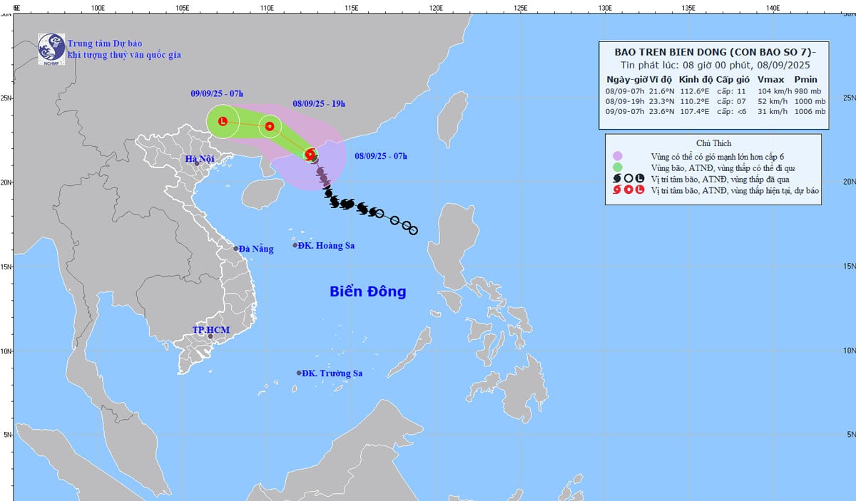
| Location and path of storm No. 7. Photo: KTTV. |
According to the National Center for Hydro-Meteorological Forecasting, at 7:00 a.m. on September 8, the center of the storm was located at about 21.6 degrees North latitude; 112.6 degrees East longitude, in the coastal waters of Guangdong province (China). The strongest wind near the center of the storm was level 11 (103 - 117 km/h), gusting to level 13. Moving in the North-Northwest direction, 20 - 25 km/h.
Forecast, by 7:00 p.m. on September 8, the storm will move northwest at a speed of 20-25 km/h, gradually weakening into a tropical depression. The storm is located at 23.3N-110.2E; on the mainland of Guangxi province (China), the storm intensity is level 7, gusting to level 9. Dangerous area North of latitude 20.0N; longitude 110.5-114.5E, the disaster risk level is level 3, the affected area is the northwest sea area of the North East Sea.
At 7:00 a.m. on September 9, the West Northwest speed was 20 - 25 km/h, gradually weakening into a low pressure area 23.6N-107.4E; on the mainland of Guangxi province (China), the storm intensity was below level 6.
Due to the storm's influence, the northwest sea area of the North East Sea has strong winds of level 6-8, near the storm's center, strong winds of level 10-11, gusts of level 13; waves 4-6m high, rough seas. Ships operating in the above-mentioned dangerous areas are likely to be affected by storms, whirlwinds, strong winds, and large waves.
Source: https://baothainguyen.vn/tai-nguyen-moi-truong/202509/bao-so-7-do-bo-vao-trung-quoc-hoan-luu-bao-anh-huong-den-viet-nam-8782940/


![[Photo] National Assembly Chairman Tran Thanh Man attends the inauguration ceremony of the Memorial Site of National Assembly Standing Committee Chairman Bui Bang Doan](https://vphoto.vietnam.vn/thumb/1200x675/vietnam/resource/IMAGE/2025/9/28/6feba23492d14b03b05445dd9f1dba88)


Comment (0)