
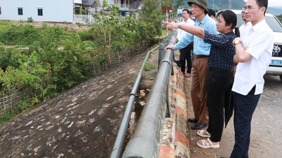
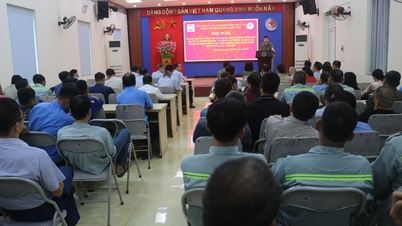
On the afternoon of September 22, the Ministry of Agriculture and Environment held a meeting to deploy response work to super typhoon Ragasa.
Tonight, super typhoon Ragasa enters the East Sea
Reporting at the meeting, Mr. Mai Van Khiem, Director of the National Center for Hydro-Meteorological Forecasting, said that at 5:00 p.m. the storm was at about 19.4 0 N; 121.7 0 E; level 17 intensity, gusting above level 17.
“After 10 p.m. tonight, the storm will officially enter the East Sea and become storm number 9 in 2025,” said Mr. Khiem.
Mr. Khiem said that through the analysis of cross-sectional satellite data through the center of the storm, it showed that the convective cloud area around the storm developed very strongly, with high cloud tops and cloud top temperatures of -70 0 C to -80 0 C. The center of the storm was clear, hot, with temperatures above 15 0 C (hot center).

Mr. Mai Van Khiem, Director of the National Center for Hydro-Meteorological Forecasting.
The greater the difference between the cloud top temperature around the center of the storm and the eye, the stronger the storm. The storm cloud organization is developing, with no sign of decreasing below level 17 in the next six hours.
Continuing the analysis, Mr. Khiem said that in the North there is high continental pressure, dry air mass from the North can affect the storm structure.
It is forecasted that the storm will likely enter Guangdong, weaken over mainland China, and then move down to the Gulf of Tonkin. The storm will enter the Gulf of Tonkin around the night of September 24 and early morning of September 25. At that time, the storm's intensity may decrease to around level 9-10 on mainland and level 11-12 in the Gulf of Tonkin.
However, despite weakening, the storm's circulation is still very wide and dangerous, possibly causing strong winds, big waves and heavy rain for the Northern and North Central provinces, especially from September 25 to 26.
"With the current forecast scenario of the storm's movement, the storm's impact area is from Quang Ninh - Ha Tinh . The strongest storm wind area is from Quang Ninh - Thanh Hoa (coastal wind level 7-9, gusts 10-12, storm center level 9-11, gusts 14, deeper inland 6-7, gusts 9-10). The period of strong winds from the morning of September 25th will last until the night of September 25th.
"Heavy rain will be concentrated in the North, Thanh Hoa - Ha Tinh with rainfall of 70-150 mm. The rain center will be concentrated in Thai Nguyen, South Tuyen Quang, Lao Cai , Phu Tho, the Northern Delta will have rain of 150-250 mm, locally over 450 mm" - Mr. Khiem said.
According to the Department of Dyke Management and Natural Disaster Prevention and Control, as of 4 p.m. today, 54,058 vehicles/215,743 workers have been notified, counted, and instructed. The vehicles have received warning information, and no vehicles are in the storm's affected area.
According to the report of the Ministry of Construction, the port area from Quang Ninh to Khanh Hoa has 874 active ships, including 382 seagoing ships and 492 inland waterway vehicles. The provinces and cities from Quang Ninh to Hue have 161,354 hectares of aquaculture, 31,812 cages, and 3,875 aquaculture huts. The winter-spring rice area in the North has been planted with more than 800,000 hectares, and is in the stage of heading and ripening; the North Central region has nearly 130,000 hectares that have not been harvested.
The strongest storm in history in the East Sea
Concluding the meeting, Deputy Minister of Agriculture and Environment Nguyen Hoang Hiep said that flood and storm prevention work has now been professionally organized, so we must have a firm grasp of the situation to have a more comprehensive and effective solution.
“At this point, it can be confirmed that storm No. 9, when entering the East Sea, will be the strongest storm in the world in 2025 according to current measurements. This is also the strongest storm ever recorded in history in the East Sea region,” Mr. Hiep emphasized.

The meeting was chaired by Deputy Minister of Agriculture and Environment Nguyen Hoang Hiep.
The Deputy Minister also said that it is forecasted that in the early morning of September 23, around 1-2 am, the storm will officially enter the East Sea. According to the current scenario, when entering the East Sea, due to some unfavorable factors, the storm may gradually decrease in intensity. It is forecasted that from the early morning of September 25, the storm will begin to affect the Gulf of Tonkin, then linger there, and then make landfall at noon or early afternoon of September 25. When entering the Gulf of Tonkin, the storm is likely to maintain level 9-10, gusting to level 12-14; when making landfall, the intensity will be around level 8-9, gusting to level 11-12.
However, he said this is just a forecast, the accuracy is not high. Therefore, the storm may be stronger or weaker but will definitely affect Vietnam, first of all at sea. Therefore, the first thing is to strictly control the activities of ships.
The leader of the Ministry of Agriculture and Environment said that the Prime Minister has issued Official Dispatch 170, requesting the Border Guard, Construction, Transport, and Fisheries forces to coordinate in controlling and not allowing boats to go to sea from today without management and counting.
The second issue is aquaculture cages. Currently, the Northern, North Central and coastal regions have about 165,000 hectares of aquaculture, a very large number that needs to be strictly controlled.
The next concern is heavy rain and reservoir safety. According to current procedures, hydroelectric and irrigation reservoirs are at the end of the main flood season, many of which are almost full. If the storm causes 150-450 mm of rain, operations will be very difficult. Therefore, it is necessary to closely monitor meteorological bulletins to determine appropriate flood discharges, avoiding passive situations like some previous years.
In addition, this storm is very strong, has a wide circulation, and combined with cold air, it can cause extreme weather phenomena such as thunderstorms, tornadoes, lightning, and localized heavy rain... It is difficult to forecast accurately, so it is necessary to immediately warn ships, especially in the Gulf of Tonkin.
Another important issue is the crop. There are currently more than 810,000 hectares of rice, of which only about 200,000 hectares have been harvested, and more than 600,000 hectares are still green. If a storm hits, the damage will be huge. Therefore, localities need to urgently harvest the ripe rice area and proactively take measures to protect crops and fruit trees.
Finally, regarding forecasting and communication, Mr. Hiep assessed that this is a very strong storm, requiring a different response. He suggested that the Hydrometeorological Center issue bulletins every 3 hours. At the same time, closely coordinate with the press and media to provide accurate and timely information to the people, avoiding subjectivity or excessive reporting that causes panic.
"We need to promote the 112 hotline so that people know and call when they need disaster assistance. This is a very important communication channel, but many people do not fully understand it. We will continue to base on the situation to advise the Government and the Prime Minister, and coordinate with localities to respond," said Mr. Hiep.
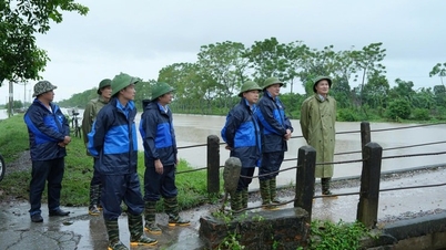
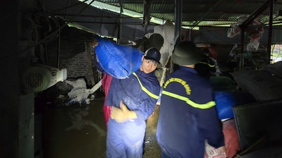
To respond to storm No. 9, Major General Pham Hai Chau - Deputy Director of the Department of Rescue and Relief (Ministry of National Defense), said that currently, units in the area expected to be affected by the storm have prepared plans and strategies. More than 300,000 militia officers and soldiers, 8,000 vehicles and six aircraft are ready to respond when situations arise. The Ministry of National Defense has directed the Border Guard Command at sea routes to call, notify, and relay information about the storm's direction. Currently, more than 54,000 vehicles and more than 200,000 fishermen have been called, counted, and instructed to know the storm's direction to take safe shelter. |
Source plo.vn
Source: https://baophutho.vn/sieu-bao-ragasa-la-con-bao-manh-nhat-trong-lich-su-o-bien-dong-239967.htm
![[Photo] Panorama of the cable-stayed bridge, the final bottleneck of the Ben Luc-Long Thanh expressway](https://vphoto.vietnam.vn/thumb/1200x675/vietnam/resource/IMAGE/2025/9/30/391fdf21025541d6b2f092e49a17243f)
![[Photo] Solemn opening of the 12th Military Party Congress for the 2025-2030 term](https://vphoto.vietnam.vn/thumb/1200x675/vietnam/resource/IMAGE/2025/9/30/2cd383b3130d41a1a4b5ace0d5eb989d)
![[Photo] The 1st Congress of Phu Tho Provincial Party Committee, term 2025-2030](https://vphoto.vietnam.vn/thumb/1200x675/vietnam/resource/IMAGE/2025/9/30/1507da06216649bba8a1ce6251816820)

![[Photo] President Luong Cuong receives President of the Cuban National Assembly Esteban Lazo Hernandez](https://vphoto.vietnam.vn/thumb/1200x675/vietnam/resource/IMAGE/2025/9/30/4d38932911c24f6ea1936252bd5427fa)
![[Photo] General Secretary To Lam, Secretary of the Central Military Commission attends the 12th Party Congress of the Army](https://vphoto.vietnam.vn/thumb/1200x675/vietnam/resource/IMAGE/2025/9/30/9b63aaa37ddb472ead84e3870a8ae825)


Comment (0)