
Nowadays, when coming to Ca Mau Cape, walking in the space of Ca Mau Cape Cultural Tourism Park, visitors can not only visit the National GPS coordinate landmark 0001; the Ho Chi Minh road landmark - the end of Ca Mau, km 2436; the breakwater; the symbol of the country's ship always facing the open sea; take souvenir photos with snails, mudskippers, sea crabs - the typical products of the land at the end of the Fatherland; enjoy specialties of the Cape such as: shrimp, sour soup with pineapple fish, grilled mudskippers, snails stir-fried with coconut...; enjoy the art form of Southern amateur music; shop for local products such as: dried shrimp, crabs, mangrove chopsticks... but most especially, visitors can visit the Hanoi flagpole at Ca Mau cape, a project with historical significance, educating national traditions, awarded by the Party Committee, government and people of Hanoi to the Party Committee, government and people of Ca Mau province. Hanoi Flag Tower is located on the sacred southernmost tip of the Fatherland with the red flag with yellow star flying proudly in front of the sea, full of meaning containing the deep affection of the Party Committee, government and people of Hanoi city for Ca Mau. At the same time, it is a symbol of the pride of national unity on the beloved "S" shaped strip of land facing the sacred East Sea of the Fatherland.
Not only the Hanoi flagpole at Ca Mau Cape, but also in the Ca Mau Cape Cultural and Tourist Park, there is Lac Long Quan Temple and Mother Statue facing the East Sea. This is considered a cluster of works that represents the morality of "When drinking water, remember its source" and is one of the meaningful tourism symbols of Ca Mau Cape. The image of the mother next to Lac Long Quan's father Temple in the southernmost land of the Fatherland - where "The land knows how to bloom, the forest knows how to walk and the sea thrives", is the gratitude of today's descendants to their ancestors who "went up the forest, down to the sea" to expand the territory. Lac Long Quan Temple and Mother Statue are forever the spiritual support for generations of Vietnamese descendants who always keep the faith and determination to protect the sovereignty of the sea and islands, protect the independence and eternal development of the nation.
After a period of development and expansion in scale, the national tourist area of Ca Mau Cape now has an area of 159.7 hectares, about 115km from the center of Ca Mau city, located in the territory of Con Mui Hamlet, Dat Mui Commune, Ngoc Hien District, Ca Mau Province. Ca Mau Cape is surrounded by the East Sea and the West Sea (Gulf of Thailand). This is the southernmost land of Vietnam, a sacred place not only for the people of Ca Mau but also for any Vietnamese people who want to set foot on it.
Itinerary of attractions:
Ho Chi Minh Trail Ending Point > Mother Statue - Lac Long Quan Temple > Ca Mau Cape Ship Symbol > GPS National Coordinates Landmark 0001 > Hanoi Flagpole at Ca Mau Cape > Ca Mau Crab Symbol.
1. The end point of the Ho Chi Minh trail
Ho Chi Minh Road starts from Pac Bo, Cao Bang province, passing through 28 provinces and cities to the end point at Ca Mau Cape. The Ho Chi Minh Road's end point at Ca Mau Cape was started on February 15, 2017 and completed on March 15, 2019. The project has 3 main points including: 1 central pillar 19m high with stylized water coconut leaves and the name of the Ho Chi Minh Road's end point and Km 2436 and 2 reliefs, both made of ceramic brought from the North for construction. Two reliefs on both sides: On the right of the high pillar is a relief depicting the image of fighting and defending the homeland of Ca Mau people; On the left of the high pillar is a relief depicting the scene of construction and development of Ca Mau homeland.
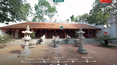
2. Mother Statue - Lac Long Quan Temple
The Temple and Statue area has a total area of 1,758 square meters, and construction started on June 11, 2019 in Zone I of Mui Ca Mau Cultural and Tourism Park.
The temple has an area of 149 m2, built of rosewood, including 3 rooms and 2 wings. The main door has two parallel sentences:
"Great ambition, far-reaching love, meaning of parting, spring and summer, two thousand new mountains and rivers
Deep gratitude, Ca Mau reunites the children and grandchildren of hundreds of thousands of former spouses"
The 50 tablets on the altar symbolize the 50 children who followed their father to the sea.
Lac Long Quan Statue: bronze from Dai Bai bronze casting village (Bac Ninh), the outside is plated with gold and silver.
In the North, there are two places that worship Lac Long Quan: Phu Tho and Ha Tay.
The 6m high statue of Mother, next to her children, is a symbolic image of the beauty of a Mother and the historical story of the origin of the Vietnamese people as "children of the Dragon and Fairy".
In Vietnam, there are two places with Lac Long Quan temples: Phu Tho and Ha Tay (now Hanoi).
Stele
On the left side of the Temple is a stone engraved with two very profound and meaningful sayings of President Ho Chi Minh on September 19, 1954 during his visit to Hung Temple: "The Hung Kings had the merit of building the country. We, uncle and nephew, must work together to protect the country."
Those words have become a sacred call of the country, resounding in the soul of every Vietnamese child in every region, with every generation, Uncle Ho's advice is not only for the generation of that day, the generation of today but also for future generations, a word that echoes through the ages, forever with descendants. The morality of "When drinking water, remember its source" shows national pride and self-respect, and at the same time strengthens us, striving to bring the country to civilization and prosperity is the duty, the sentiment, the responsibility and the sacred duty of all those who carry the blood of Lac Hong.
3. Ca Mau Cape ship symbol
The symbol was put into service on April 27, 2003, maintained and relocated to the end of the breakwater in 2020 with the image of a ship always facing the open sea as in the two verses Xuan Dieu wrote about Ca Mau "My homeland is like a ship; The bow of our boat is Ca Mau Cape".
Miniature panel with the image of a ship and sails always full of wind facing the sea with the area of the ship symbol is 19.2m x 19.2m. The bow of the ship is 3.5m wide, 9.05m long, and 7m high. On the sail is the inscription "Ca Mau Cape coordinates 8°37'30s North latitude, 104°43' East longitude". Coming here, visitors all have the same feeling of excitement and emotion because they have set foot on the sacred land of the southernmost tip of the Fatherland Vietnam.
4. National GPS Coordinate Marker 0001
The coordinate marker was determined in January 1995, designed, built beautifully and solidly, in the shape of a wind rose. Ca Mau Cape with the National coordinate marker is a red address, a sacred land that every Vietnamese person wishes to set foot on.
The global positioning system identifies the National Coordinate Marker GPS0001 as the southernmost point on the mainland of Vietnam. This is one of the four extreme points of Vietnam's territory on the mainland. The northernmost point is Lung Cu Flagpole (Ha Giang), the westernmost point is Apa Chai commune (Muong Nhe, Dien Bien), the easternmost point is Mui Doi (Van Ninh, Khanh Hoa) and the southernmost point is the southernmost point of the National Coordinate Marker GPS0001 (Dat Mui, Ca Mau). Around the campus, many trees were planted as souvenirs by high-ranking leaders of the Party and State who visited and worked at Mui Ca Mau.
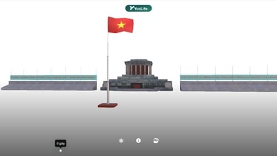
5. Hanoi Flag Tower symbol at Ca Mau Cape
The construction of the Ca Mau Cape Flagpole symbol began on January 16, 2016. The project was invested by Hanoi City.
The Flagpole is designed to simulate the ancient Hanoi Flagpole architecture, built solidly and modernly, capable of withstanding storms and sea erosion. The total area is more than 16,000 m2 and has a height of 45m, solidly built with 3 floors of base and the body of the flagpole. Specifically as follows:
+ 1st floor: 4m high, each side is 45m;
+ 2nd floor: 4.4m high, each side is 28.2m;
+ 3rd floor: 6m high, each side is 15m;
+ Flagpole Tower is 25.2m high, octagonal conical shape;
From the 1st to the 3rd floor there is a spiral staircase leading up, on top is an octagonal floor 3.9m high, area 39m2; The octagonal roof floor is 1.5m high.
On the 3rd floor is the cylindrical body of the Flagpole with 8 sides gradually tapering upwards. The spiral trapezoidal pillar is illuminated (and ventilated) by asterisk-shaped and fan-shaped windows. When going up to the upper floors, we can see the whole landscape of the Ca Mau mangrove forest, the vast East Sea, the beautiful and poetic Hon Khoai island cluster between the East Sea and the alluvial plains of the West Sea. The Flagpole has a large campus, can serve performances, festivals, organize events, has a ladder leading to the flagpole to serve tourists, the base floor area displays pictures, artifacts and historical documents...
The Flagpole project at Ca Mau Cape has contributed to Ca Mau a project with beautiful artistic and architectural values bearing the sacred cultural and historical imprint. The Flagpole also has the value of affirming national territorial sovereignty, national sea and island sovereignty, uniting the North and the South, and connecting the sentiments of the Capital with the homeland of Ca Mau Cape and international friends.
6. Ca Mau Crab Symbol
The crab symbol was started construction on July 9, 2019 using composite material with high durability, suitable for the weather conditions of Dat Mui. The crab has dimensions of 5m x 2.8m x 1.72m.
This dish is famous far and wide not only for its firm meat and delicious roe but also for its attractive flavor of the southernmost tip of the country. Just eat Ca Mau sea crab once and you will remember the flavor forever and want to come back to enjoy it. The Cape has been given by Mother Nature a wonderful gift, Ca Mau sea crab, that everyone wants to taste at least once.


![[Photo] General Secretary To Lam receives Chairman of the State Duma of the Russian Federation Vyacheslav Volodin](https://vphoto.vietnam.vn/thumb/1200x675/vietnam/resource/IMAGE/2025/9/29/3814a68959e848f586178624b6bd66e5)
![[Photo] Prime Minister Pham Minh Chinh meets with Chairman of the State Duma of the Russian Federation Vyacheslav Volodin](https://vphoto.vietnam.vn/thumb/1200x675/vietnam/resource/IMAGE/2025/9/29/08ca17cb0c46432dbdb94f9eaf73b47a)
![[Photo] President Luong Cuong receives Chairman of the State Duma of the Russian Federation Vyacheslav Volodin](https://vphoto.vietnam.vn/thumb/1200x675/vietnam/resource/IMAGE/2025/9/29/6bd456e072504df3a468acbf9b7989c8)


![[Photo] Joy on the new Phong Chau bridge](https://vphoto.vietnam.vn/thumb/1200x675/vietnam/resource/IMAGE/2025/9/28/b00322b29c8043fbb8b6844fdd6c78ea)


![[Photo] President Luong Cuong receives Chairman of the State Duma of the Russian Federation Vyacheslav Volodin](https://vphoto.vietnam.vn/thumb/402x226/vietnam/resource/IMAGE/2025/9/29/6bd456e072504df3a468acbf9b7989c8)


Comment (0)