On September 8, in Thanh Hoa, the consequences of storm No. 3 were still quite severe. Thanh Hoa Newspaper continuously updated the latest developments sent by reporters.
Another fishing boat of Thanh Hoa fishermen sank while taking shelter from storm number 3.
According to information from the Steering Committee for Natural Disaster Prevention, Search and Rescue and Civil Defense (PCTT, TKCN and PTDS) of Nghi Son town, Hai Hoa Border Guard Station and Hai Thanh Ward People's Committee have just received information that 2 fishing boats with registration numbers TH-91926-TS and TH-90658-TS of the people of Thuong Hai residential group, Hai Thanh ward, captained by Mr. Nguyen Van Than, born in 1956, and 9 crew members lost contact at 11:00 on September 7, 2024 while taking shelter from the storm at Cai Rong Port, Cai Rong town, Van Don district, Quang Ninh province.
After receiving the information, the units coordinated to go to the family to encourage, visit the family, and grasp the information. At the same time, coordinated with relevant authorities and forces to connect and contact the vehicle owner and crew members.
By 2 p.m. on September 8, relatives and local authorities had contacted the captain and crew members on both ships. Currently, the crew members on board are still safe. However, due to the impact of rain and storms, the ship numbered TH-91926-TS of Mrs. Nguyen Thi Cuc's family in Hai Thanh ward sank.
Previously, four fishing boats of Thanh Hoa fishermen sank while anchoring to avoid the storm in Cam Pha city, Quang Ninh province.
Le Hoa
Floods on the Buoi River are likely to reach alert level II tonight.
At 3:00 p.m. on September 8, the Provincial Steering Committee for Natural Disaster Prevention, Search and Rescue and Civil Defense continued to issue telegram No. 08 to issue Alert II on the Buoi River.
![[Update] - Floods in Thanh Hoa: Another fishing boat of Thanh Hoa fishermen sank while taking shelter from storm number 3](https://www.vietnam.vn/thanhhoa/wp-content/uploads/2024/09/Cap-nhat-Mua-lu-tai-Thanh-Hoa-Them-1.png)
The water level of the Buoi River at Kim Tan continued to rise on the afternoon of September 8.
Accordingly, the water level of the Buoi River is rising rapidly. At 2:00 p.m. on September 8, 2024, the water level of the Buoi River measured at Kim Tan Hydrological Station was 10.36 m, 0.64 m below Alarm Level II. It is forecasted that the water level of the Buoi River at Kim Tan Hydrological Station is likely to reach Alarm Level II (Alarm Level II +11.00 m) between 8:00 and 10:00 p.m. on September 8, 2024.
The Steering Committee for Natural Disaster Prevention, Search and Rescue and Civil Defense of Thanh Hoa province requests the Chairmen of the People's Committees of Thach Thanh and Vinh Loc districts to:
Immediately deploy dike patrols and dike protection according to alarm levels.
Organize inspection, review and have a plan to ensure safety for dike works; especially weak dike sections and culverts under the dike in the area.
Proactively implement evacuation plans for people living in riverbank areas.
Organize a 24/7 duty seriously, closely monitor the development of floods and rains to be ready to handle situations from the first hour; promptly inform and report to the Standing Office of the Provincial Command for Natural Disaster Prevention and Control and the Standing Office of the Provincial Command for Civil Defense, Natural Disaster Response and Search and Rescue.
Le Dong
End of sea ban, allowing activities at sea and coastal areas
On the afternoon of September 8, the Provincial Steering Committee for Natural Disaster Prevention, Control, Search and Rescue and Civil Defense (PCTT,TKCN&PTDS) announced the end of the sea ban and allowed coastal and sea activities to return to normal from 3:00 p.m. on September 8, 2024.
![[Update] - Floods in Thanh Hoa: Another fishing boat of Thanh Hoa fishermen sank while taking shelter from storm number 3](https://www.vietnam.vn/thanhhoa/wp-content/uploads/2024/09/Cap-nhat-Mua-lu-tai-Thanh-Hoa-Them-1.jpg)
To proactively respond to storm No. 3 in 2024, to ensure the safety of ships and boats in the province during the storm, the Provincial People's Committee issued Official Dispatch No. 18/CD-UBND dated September 5, 2024, the Provincial Steering Committee for Disaster Prevention, Search and Rescue and Disaster Prevention issued Notice No. 18/TBPCTT, TKCN&PTDS dated September 5, 2024, requesting to ban sea travel in the province from 12:00 on September 6, 2024 until the storm is no longer affected.
Currently, storm No. 3 is gradually dissipating. The Provincial Steering Committee for Natural Disaster Prevention, Search and Rescue has announced the end of the Sea Ban Order and allowed coastal and sea activities to return to normal from 3:00 p.m. on September 8, 2024.
Le Hoi
Alarm I on Ma River
On the afternoon of September 8, the Provincial Steering Committee for Natural Disaster Prevention, Search and Rescue and Civil Defense (PCTT,TKCN&PTDS) sent a telegram to the Chairmen of the People's Committees of the districts: Cam Thuy, Vinh Loc, Yen Dinh, Hoang Hoa, Thieu Hoa and Thanh Hoa city, Sam Son city to issue a first alert on the Ma River.
![[Update] - Floods in Thanh Hoa: Another fishing boat of Thanh Hoa fishermen sank while taking shelter from storm number 3](https://www.vietnam.vn/thanhhoa/wp-content/uploads/2024/09/1725789426_726_Cap-nhat-Mua-lu-tai-Thanh-Hoa-Them-1.jpg)
Alarm I on Ma River
Currently, the water level of the Ma River is rising rapidly. At 2:00 p.m. on September 8, the water level measured at Cam Thuy Hydrological Station was 18.97 m, 0.03 m below alarm level II (19 m); at Ly Nhan Hydrological Station it was 8.85 m, 0.65 m below alarm level I (9.50 m); the Ma River water level at Ly Nhan Hydrological Station is likely to reach alarm level I (+9.50 m) at around 6:00 - 8:00 p.m. on September 8, 2024.
The Steering Committee for Disaster Prevention, Search and Rescue issued a first alert on the Ma River at Ly Nhan, requesting the Chairmen of the People's Committees of localities to immediately deploy dike patrols and protection according to the alarm levels.
Organize inspection, review and have a plan to ensure safety for dike works; especially weak dike sections and culverts under the dike in the area.
Proactively implement evacuation plans for people living in riverbank areas.
Organize a 24/7 duty seriously, closely monitor the development of floods and rains to be ready to handle situations from the first hour; promptly inform and report to the Standing Office of the Provincial Command for Natural Disaster Prevention and Control and the Standing Office of the Provincial Command for Civil Defense, Natural Disaster Response and Search and Rescue.
Lighthouse
Many traffic routes were eroded.
On September 8, landslides occurred on many National Highways in Thanh Hoa, causing difficulties for people traveling.
![[Update] - Floods in Thanh Hoa: Another fishing boat of Thanh Hoa fishermen sank while taking shelter from storm number 3](https://www.vietnam.vn/thanhhoa/wp-content/uploads/2024/09/1725789426_865_Cap-nhat-Mua-lu-tai-Thanh-Hoa-Them-1.jpg)
The road management unit placed warning posts at landslide risk points on National Highway 15.
On National Highway 15, at Km20+850 on the left side of Phu Thanh commune (Quan Hoa), a positive slope crack appeared with a risk of landslide, about 200m long, about 15m-30m high, and about 0.5m to 1m wide; at Km26+050 on the left side of the road, the positive slope landslide took up 2/3 of the road surface, making traffic difficult.
![[Update] - Floods in Thanh Hoa: Another fishing boat of Thanh Hoa fishermen sank while taking shelter from storm number 3](https://www.vietnam.vn/thanhhoa/wp-content/uploads/2024/09/1725789426_941_Cap-nhat-Mua-lu-tai-Thanh-Hoa-Them-1.jpg)
Landslides on National Highway 15C through Trung Ly commune are getting more and more serious.
On National Highway 15C, at Km64+980 (right route) in Trung Ly commune (Muong Lat), a negative slope sliding crack about 30m long appeared; at Km88+750 (right route), another crack appeared on the road surface close to the left side of the road; at Km99+020 (left route), rolling rocks blocked the road surface.
![[Update] - Floods in Thanh Hoa: Another fishing boat of Thanh Hoa fishermen sank while taking shelter from storm number 3](https://www.vietnam.vn/thanhhoa/wp-content/uploads/2024/09/1725789426_914_Cap-nhat-Mua-lu-tai-Thanh-Hoa-Them-1.jpg)
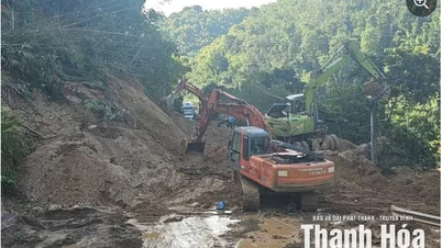
Road management units mobilized vehicles to overcome landslides on National Highway 15.
On National Highway 16 at Km11+980, landslides and fallen trees blocked the road; at Km32+200, large rocks blocked the road; at Km34+600 (left route), Km35+400 (left route) in Muong Ly commune (Muong Lat), a negative slope sliding crack appeared about 35m long.
On National Highway 217B, a longitudinal ditch is deposited at Km26+750 with a volume of about 60m3 .
![[Update] - Floods in Thanh Hoa: Another fishing boat of Thanh Hoa fishermen sank while taking shelter from storm number 3](https://www.vietnam.vn/thanhhoa/wp-content/uploads/2024/09/1725789426_965_Cap-nhat-Mua-lu-tai-Thanh-Hoa-Them-1.jpg)
Immediately after the discovery, the Department of Transport urged management units to coordinate with local authorities to propagate warnings to people and vehicles when passing through the above dangerous sections. At the same time, install warning signs at both ends of the location, tighten seat belts, prepare equipment and workers to promptly handle traffic jams.
Units take measures to handle and ensure traffic such as cutting trees, clearing sediment, placing warning signs, and barricades at landslides, sinkholes, and deeply flooded roads... Coordinate with localities to organize propaganda, arrange guards, and guide traffic to ensure safety for people and vehicles traveling on the route. Therefore, in addition to the overflow locations that are locally blocked, traffic on national highways and provincial roads is still guaranteed to be smooth, with no congestion.
Le Hoi
Nearly 38 hectares of rice and vegetables in Sam Son city were fallen and broken.
According to information from the Steering Committee for Natural Disaster Prevention, Search and Rescue and Civil Defense of Sam Son City, by 2:00 p.m. on September 8, storm No. 3 damaged nearly 38 hectares of rice and vegetables, and about 2 hectares of aquaculture area.
Currently, the City People's Committee has directed communes and wards to guide farmers to go to the fields to re-bundle fallen rice and drain water from some areas growing early winter crops.
![[Update] - Floods in Thanh Hoa: Another fishing boat of Thanh Hoa fishermen sank while taking shelter from storm number 3](https://www.vietnam.vn/thanhhoa/wp-content/uploads/2024/09/1725789428_954_Cap-nhat-Mua-lu-tai-Thanh-Hoa-Them-1.jpg)
Sam Son city authorities overcome the consequences after the storm.
For 35 broken and fallen urban trees, the City People's Committee assigned the City Construction Investment Project Management Board to urgently dig up and handle fallen trees; and re-erect fallen trees on the roads.
To proactively overcome the damage caused by storm No. 3, the City People's Committee directed wards and communes to coordinate with relevant units to actively drain water in the fields, overcome the flooding of rice and crops. Continue to inform, propagate, and guide people to stabilize production and take advantage of favorable weather conditions to continue harvesting areas that are 80% or more ripe. At the same time, direct localities to continue to count the damage caused by storms and rains.
Tran Hang
Ba Thuoc has 15 traffic points that are partially cut off.
According to information from the People's Committee of Ba Thuoc district, in the district there are 15 traffic points with high flood water, causing localized traffic disruption, including: Luong Trung commune has 2 points in Son Thuy village and Hang Kheo village, Quang Trung village; Luong Noi commune at Mo Tom spillway, Ben village; Thiet Ke commune at Cha stream dam; Ban Cong commune has 3 points on road 521B through La Han village flower garden, La Han spring area to Ca village, Kham stream area, Ba village; Co Lung commune has 2 points at Na Kha spillway and La Ca spillway; Lung Cao commune at Pon Thanh Cong village; Lung Niem commune at Uoi spillway in Lan Ngoai and Lan Trong villages; Luong Ngoai commune at Hon Uong bridge, Giau Ca village; Ha Trung commune has 3 points on road 523D through Khieng village, Dong Xong spillway, Chieng Ai village, Chong Bong spillway, Co Mu village.
![[Update] - Floods in Thanh Hoa: Another fishing boat of Thanh Hoa fishermen sank while taking shelter from storm number 3](https://www.vietnam.vn/thanhhoa/wp-content/uploads/2024/09/1725789429_653_Cap-nhat-Mua-lu-tai-Thanh-Hoa-Them-1.jpg)
Rocks rolling down from the mountain caused traffic jam in Khieng village, Ha Trung commune.
In addition, there was also a 35m subsidence on the traffic route of Don village, Thanh Lam commune; landslides on the slope of National Highway 521C through Thanh Son commune and National Highway 521B through Leo village, Thanh Lam commune.
![[Update] - Floods in Thanh Hoa: Another fishing boat of Thanh Hoa fishermen sank while taking shelter from storm number 3](https://www.vietnam.vn/thanhhoa/wp-content/uploads/2024/09/1725789429_372_Cap-nhat-Mua-lu-tai-Thanh-Hoa-Them-1.jpg)
The Provincial Steering Committee for Natural Disaster Prevention, Search and Rescue and Civil Defense and leaders of Ba Thuoc district inspected the spillway in Ha Trung commune.
Regarding agriculture , 349.52 hectares of rice; 23.95 hectares of flowers; 169.85 hectares of annual crops; 8.1 hectares of ponds and lakes were damaged. Floodwaters also swept away 30 steel baskets, breaking the Ta Lun dam in Khang village, affecting irrigation works. In Ban Cong commune, 85 waterwheels and 1 iron boat were swept away.
To cope with the circulation of storm No. 3, the leaders of Ba Thuoc district directed the People's Committees of communes and towns to continue to inspect vulnerable areas to have plans to ensure the safety of people and property; the authorities urgently moved belongings of households with damaged roofs and high risk of being affected by natural disasters to safe places and supported with essential conditions to ensure daily life.
Tien Dong - Van An
4 Thanh Hoa fishing boats sank, 1 fisherman missing in Quang Ninh
Immediately after storm No. 3 passed, the People's Committee of Quang Xuong district directed localities to assign teams to go directly to families of vehicle owners and boat docks to grasp information about fishing boats taking shelter from the storm in provinces and cities across the country. Through grasping and checking in Quang Xuong district, there were 4 vessels that sank while taking shelter from the storm in Cam Pha city, Quang Ninh province. These are the vessels:
Fishing boat with registration number TH - 92255 - TS owned by owner Vu Van Phu in Hai village, Quang Nham commune sank at Ben Do address, Cam Thuy village, Quang Hanh ward. At the time the boat broke its anchor rope and sank, there were 2 crew members on board, Vu Van Cuong in Quang Nham commune and Nguyen Van Bon in Quang Thach commune. However, at the time the boat sank, Mr. Cuong was rescued by a ship anchored nearby. Currently, Mr. Bon is missing as of 9:30 a.m. on September 8 and has not been found.
Fishing boat with registration number TH - 91180 - TS owned by Ho Van Huong in Tien village, Quang Nham commune sank at Ben Do address, Cam Thuy village, Quang Hanh ward. At the time of the sinking, there were 2 crew members on board but both were rescued safely by another boat.
Fishing boat TH - 92379 - TS owned by Tran Van Nhan in Trung village, Quang Nham commune sank at Ben Do address, Cam Thuy village, Quang Hanh ward. At the time the boat sank, there were 2 crew members on board, both were rescued safely by another boat.
Fishing boat TH - 90149 - TS owned by Hoang Van Hai in Trung village, Quang Nham commune sank at Ben Do, Cam Thuy village, Quang Hanh ward. At the time the boat sank, there were 4 crew members on board, all of whom were safely rescued by another boat.
The People's Committee of Quang Xuong district is coordinating and requesting the Department of Agriculture and Rural Development, the Steering Committee for Natural Disaster Prevention, Search and Rescue and Civil Defense of Thanh Hoa and Quang Ninh provinces to support the search for missing crew member Nguyen Van Bon.
Le Hoa
Nearly 70 hectares of rice fields about to be harvested in Ha Trung were flooded.
According to statistics from the Steering Committee for Natural Disaster Prevention, Search and Rescue and Civil Defense of Ha Trung district, by 10:00 a.m. on September 8, storm No. 3 had caused nearly 70 hectares of rice that were about to be harvested to collapse, concentrated in the communes of Yen Son, Ha Binh, Ha Tan, Ha Lai, Yen Duong, Ha Son, Ha Tien... Currently, the People's Committees of the communes have directed the people to overcome the problem by urgently harvesting. The rice areas that have not been harvested are bundled up to ensure that the yield and quality are not affected.
![[Update] - Floods in Thanh Hoa: Another fishing boat of Thanh Hoa fishermen sank while taking shelter from storm number 3](https://www.vietnam.vn/thanhhoa/wp-content/uploads/2024/09/1725789431_838_Cap-nhat-Mua-lu-tai-Thanh-Hoa-Them-1.jpg)
Farmers in Yen Son commune built and forced the rice area to collapse due to the effects of storm winds.
Along with that, some trees planted along the road, trees planted in people's houses and some sections of the surrounding walls of public works were knocked down. There were 2 tilted electric poles in Linh Toai and Ha Thai communes that were promptly handled and repaired by the electricity sector...
![[Update] - Floods in Thanh Hoa: Another fishing boat of Thanh Hoa fishermen sank while taking shelter from storm number 3](https://www.vietnam.vn/thanhhoa/wp-content/uploads/2024/09/1725789432_167_Cap-nhat-Mua-lu-tai-Thanh-Hoa-Them-1.jpg)
People of Ha Dong commune clean up fallen trees after storm number 3.
To proactively overcome the damage caused by storm No. 3, the District Steering Committee for Natural Disaster Prevention, Search and Rescue and Civil Defense directed communes and towns to guide and propagate people to clean up fallen trees; harvest all areas that are ready for harvest, erect and tie all areas of rice that have collapsed due to the impact of storm winds, and carry out re-production to limit damage and stabilize life. At the same time, direct relevant units to review, inspect, and urgently overcome the impact caused by storm No. 3.
Phan Nga
Prepare evacuation plan when Buoi River water level reaches alarm level 2
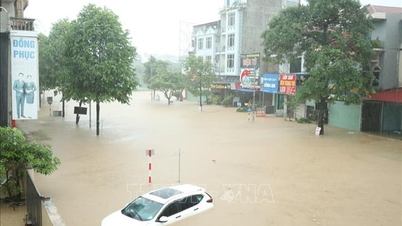
Heavy rain caused the water level of the Buoi River in Thach Thanh to rise, causing local flooding of some traffic routes, affecting people's travel.
![[Update] - Floods in Thanh Hoa: Another fishing boat of Thanh Hoa fishermen sank while taking shelter from storm number 3](https://www.vietnam.vn/thanhhoa/wp-content/uploads/2024/09/1725789432_488_Cap-nhat-Mua-lu-tai-Thanh-Hoa-Them-1.jpg)
The Buoi River is rising.
Specifically, in Thanh Minh commune, the inter-village road was flooded with a length of 1km, about 40cm deep. In Thanh Cong commune, the road to Dong Chu village was also flooded with a length of 0.4km. The road from Chinh Thanh village, Thanh Truc commune to Thanh Cong commune was also flooded with a depth of about 70cm and a length of 50m.
Local authorities have put up signs and barriers to prevent people and vehicles from entering dangerous areas.
In addition, the Buoi River also rose to near Provincial Road 523, passing through Thanh Truc Commune Office. The government mobilized forces to build up land to prevent the river from overflowing into the fields.
![[Update] - Floods in Thanh Hoa: Another fishing boat of Thanh Hoa fishermen sank while taking shelter from storm number 3](https://www.vietnam.vn/thanhhoa/wp-content/uploads/2024/09/1725789433_460_Cap-nhat-Mua-lu-tai-Thanh-Hoa-Them-1.jpg)
The road from Chinh Thanh village, Thanh Truc commune to Thanh Cong commune is deeply flooded.
Regarding production, storms and rains have flooded 208.2 hectares of crops in Thach Thanh district. Of which, more than 156.4 hectares of rice, 51 hectares of sugarcane, 1.5 hectares of corn...
![[Update] - Floods in Thanh Hoa: Another fishing boat of Thanh Hoa fishermen sank while taking shelter from storm number 3](https://www.vietnam.vn/thanhhoa/wp-content/uploads/2024/09/1725789433_941_Cap-nhat-Mua-lu-tai-Thanh-Hoa-Them-1.jpg)
Thanh Truc Commune mobilized local forces to reinforce some culvert sections and fill with soil to prevent Buoi River from overflowing Provincial Road 523.
Currently, the water level of Buoi River is rising. At 8:30 a.m. on September 8, the Steering Committee for Natural Disaster Prevention, Search and Rescue and Civil Defense of Thanh Hoa province issued Official Dispatch No. 06, declaring Alert I on Buoi River at Kim Tan.
Thach Thanh district is continuing to organize 24/7 on-duty, closely monitoring the water level of the Buoi River and the flooding situation in the district to promptly command and implement response plans. Directing communes and towns with dykes and areas along the Buoi River to regularly monitor weather developments to promptly organize the evacuation of people and property from flooded areas if the river water rises above alert level 2...
Do Duc
Quan Son completed repairing 30 houses with blown-off roofs.
According to information from the People's Committee of Quan Son district, storm No. 3 injured one person; 30 houses had their roofs partially blown off; nearly 40 hectares of rice in Trung Tien, Son Dien, Tam Lu communes and Son Lu town were destroyed; and one broadcasting tower was broken.
![[Update] - Floods in Thanh Hoa: Another fishing boat of Thanh Hoa fishermen sank while taking shelter from storm number 3](https://www.vietnam.vn/thanhhoa/wp-content/uploads/2024/09/1725789434_999_Cap-nhat-Mua-lu-tai-Thanh-Hoa-Them-1.jpg)
Trees were broken.
Along with that, the negative slope of the road connecting from Highway 217 to Ngam village (Son Dien) with a length of over 50m was eroded; on Highway 217, Highway 16, some inter-commune roads, trees were broken.
Quan Son district has assigned members of the Steering Committee for Natural Disaster Prevention, Search and Rescue and Civil Defense to go directly to the assigned communes to direct damage recovery and visit and encourage families with injured people.
Directing the People's Committees of Tam Thanh, Son Dien, Muong Min, Na Meo communes and Son Lu town to mobilize forces to repair and restore roofs for people. At the same time, put up signs, stretch warning ropes, and protect the landslide road section.
![[Update] - Floods in Thanh Hoa: Another fishing boat of Thanh Hoa fishermen sank while taking shelter from storm number 3](https://www.vietnam.vn/thanhhoa/wp-content/uploads/2024/09/1725789434_17_Cap-nhat-Mua-lu-tai-Thanh-Hoa-Them-1.jpg)
Quan Son district leaders inspected the facility.
![[Update] - Floods in Thanh Hoa: Another fishing boat of Thanh Hoa fishermen sank while taking shelter from storm number 3](https://www.vietnam.vn/thanhhoa/wp-content/uploads/2024/09/1725789435_570_Cap-nhat-Mua-lu-tai-Thanh-Hoa-Them-1.jpg)
Quan Son district leaders inspected the facility.
Quan Son district has mobilized forces and families to repair 30 houses with blown-off roofs. Fallen trees and landslides on the roads have also been repaired by authorities.
The district is continuing to direct communes and towns to mobilize all forces to quickly overcome the consequences of the storm and stabilize production development.
Xuan Cuong
More than 325 hectares of rice in Nga Son were broken and felled; many greenhouses and net houses were damaged.
According to statistics from the Steering Committee for Natural Disaster Prevention, Search and Rescue and Civil Defense of Nga Son district, storm No. 3 caused 325.6 hectares of rice to fall, of which 5 hectares were damaged by over 70%; 9.7 other crops were completely damaged. In addition, heavy rain and wind damaged some areas of greenhouses and net houses in the communes of Nga Bach and Nga Phuong...
![[Update] - Floods in Thanh Hoa: Another fishing boat of Thanh Hoa fishermen sank while taking shelter from storm number 3](https://www.vietnam.vn/thanhhoa/wp-content/uploads/2024/09/1725789435_366_Cap-nhat-Mua-lu-tai-Thanh-Hoa-Them-1.jpg)
Local people built and tied rice that was broken after storm number 3.
To proactively overcome the damage caused by storm No. 3, the District Steering Committee for Natural Disaster Prevention, Search and Rescue and Civil Defense directed communes, towns and irrigation units to proactively drain water to protect crops, adopted children and people's property.
At the same time, instruct people to urgently drain water in the fields and mobilize human resources and prepare materials to stand the rice upright to avoid affecting productivity.
Along with that, localities continue to review, compile statistics and deploy remedial measures to minimize damage caused by storms and rains...
Le Hoa
Cam Thuy: 387 hectares of rice fell; negative slope collapsed, cracking 1.2m deep into the road surface
In Cam Thuy district, a house in Cam Thanh commune had its roof completely blown off. The storm also broke a number of trees on the roads. Along with that, 387 hectares of rice were damaged, of which 40.5 hectares were partially flooded. In addition, 35 hectares of crops were damaged.
![[Update] - Floods in Thanh Hoa: Another fishing boat of Thanh Hoa fishermen sank while taking shelter from storm number 3](https://www.vietnam.vn/thanhhoa/wp-content/uploads/2024/09/1725789436_112_Cap-nhat-Mua-lu-tai-Thanh-Hoa-Them-1.jpg)
Cam Thuy district authorities urgently cleared up fallen trees on the roads.
Regarding traffic, due to the impact of storm No. 3, the road section from Thon Muat, Cam Thanh commune to Ba Thuoc had a landslide and a deep crack in the concrete road surface of 1.2m.
![[Update] - Floods in Thanh Hoa: Another fishing boat of Thanh Hoa fishermen sank while taking shelter from storm number 3](https://www.vietnam.vn/thanhhoa/wp-content/uploads/2024/09/1725789437_459_Cap-nhat-Mua-lu-tai-Thanh-Hoa-Them-1.jpg)
Cam Thuy district authorities inspect unharvested rice areas.
Cam Thuy district has directed communes, towns, and sectors to concentrate resources and means to overcome floods and drain water for crops that are likely to be flooded in the entire district. Directed to ensure security and order and overcome consequences caused by floods.
Nguyen Dat
Issued Alert I on Buoi River
At 8:30 a.m. on September 8, the Steering Committee for Natural Disaster Prevention, Search and Rescue and Civil Defense of Thanh Hoa province issued Official Dispatch No. 06, issuing Alert I on the Buoi River at Kim Tan.
![[Update] - Floods in Thanh Hoa: Another fishing boat of Thanh Hoa fishermen sank while taking shelter from storm number 3](https://www.vietnam.vn/thanhhoa/wp-content/uploads/2024/09/1725789437_147_Cap-nhat-Mua-lu-tai-Thanh-Hoa-Them-1.jpg)
The water level of the Buoi River at Kim Tan reached 9.08m at 8:00 a.m. on September 8 and is continuing to rise.
Accordingly, at 8:00 a.m. on September 8, 2024, the water level of the Buoi River measured at Kim Tan Hydrological Station was 9.08 m, 0.92 m below alarm level I; at Thach Quang Hydrological Station it was 14.80 m, 0.2 m below alarm level II. The warning of the Buoi River water level at Kim Tan Hydrological Station is likely to reach alarm level I (+10.00 m) at around 11:00 a.m. on September 8, 2024.
![[Update] - Floods in Thanh Hoa: Another fishing boat of Thanh Hoa fishermen sank while taking shelter from storm number 3](https://www.vietnam.vn/thanhhoa/wp-content/uploads/2024/09/1725789437_9_Cap-nhat-Mua-lu-tai-Thanh-Hoa-Them-1.jpg)
The Steering Committee for Natural Disaster Prevention, Search and Rescue and Civil Defense, and the People's Committee Chairmen of Thach Thanh and Vinh Loc districts implement the following urgent solutions:
1. Immediately deploy dike patrols and dike protection according to alarm levels.
2. Organize inspection, review and have a plan to ensure safety for dike works; especially weak dike sections and culverts under the dike in the area.
3. Proactively implement evacuation plans for people living in riverbank areas.
4. Organize a serious 24/7 on-duty team, closely monitor the development of floods and rains to be ready to handle situations from the first hour; promptly inform and report to the Standing Office of the Provincial Command for Natural Disaster Prevention and Control and the Standing Office of the Provincial Command for Civil Defense, Natural Disaster Response and Search and Rescue.
Le Dong
Thuong Xuan: Many rice fields were damaged, the dam was deeply flooded, and some houses were damaged.
In Thuong Xuan district, due to the impact of storm No. 3, from September 6 to 9:00 a.m. on September 8, there was heavy rain (common rainfall from 90-122 mm) and wind, causing damage to many areas of crops and houses.
![[Update] - Floods in Thanh Hoa: Another fishing boat of Thanh Hoa fishermen sank while taking shelter from storm number 3](https://www.vietnam.vn/thanhhoa/wp-content/uploads/2024/09/1725789438_882_Cap-nhat-Mua-lu-tai-Thanh-Hoa-Them-1.jpg)
Part of the rice area in Ngoc Phung commune (Thuong Xuan) was destroyed.
Specifically, a house in Ngoc Phung commune had its corrugated iron roof blown off. Another house in Tho Thanh commune was also damaged by a fallen tree. The storm also broke an electric pole and severed many power lines in Bat Mot and Luan Khe communes.
Natural disasters from storm No. 3 also caused 41.5 hectares of rice in Luan Khe, Xuan Cao, Ngoc Phung, and Tan Thanh communes to collapse. 10 hectares of cassava in Xuan Cao commune were also broken.
![[Update] - Floods in Thanh Hoa: Another fishing boat of Thanh Hoa fishermen sank while taking shelter from storm number 3](https://www.vietnam.vn/thanhhoa/wp-content/uploads/2024/09/1725789439_494_Cap-nhat-Mua-lu-tai-Thanh-Hoa-Them-1.jpg)
Authorities set up barriers to prevent people and vehicles from passing through Na Cong (Van Xuan commune).
Heavy rains caused by the storm also caused water levels in rivers and streams in Thuong Xuan district to rise, causing local flooding of many spillways, cutting off traffic. Specifically, Cua Du spillway (Luan Khe commune) and Na Cong spillway (Van Xuan commune) were deeply flooded, cutting off traffic. Authorities have put up signs and barriers to prevent people and vehicles from passing through dangerous areas.
![[Update] - Floods in Thanh Hoa: Another fishing boat of Thanh Hoa fishermen sank while taking shelter from storm No. 3](https://www.vietnam.vn/thanhhoa/wp-content/uploads/2024/09/1725778440_439_Cap-nhat-Mua-lu-tai-Thanh-Hoa-Ba-Thuoc.jpg)
Leaders of Thuong Xuan district directly returned to the facility to direct the response to storm No. 3 at key locations.
Proactively responding to storm No. 3, previously the Steering Committee for Natural Disaster Prevention, Search and Rescue and Civil Defense of Thuong Xuan district organized the emergency relocation of 123 households with 500 people living in areas at high risk of floods, flash floods and landslides in Bat Mot and Yen Nhan communes; Direct communes, towns, irrigation and hydropower units, lake and dam management units to fully prepare materials to operate and prevent natural disasters in all situations...
Do Duc
Rising stream water flooded Cua Du, traffic was temporarily interrupted
According to information from the Department of Transport, heavy rain from the night of September 7 to the morning of September 8 increased river and stream levels, causing Cua Du (km 22+550), on provincial road 519B, Luan Thanh commune (Thuong Xuan) to be flooded. Currently, traffic on this route is temporarily interrupted.
![[Update] - Floods in Thanh Hoa: Another fishing boat of Thanh Hoa fishermen sank while taking shelter from storm No. 3](https://www.vietnam.vn/thanhhoa/wp-content/uploads/2024/09/1725789440_229_Cap-nhat-Mua-lu-tai-Thanh-Hoa-Them-1.jpg)
Faced with the above situation, the road management unit has taken measures to post signs to warn people not to pass through, to ensure traffic safety.
![[Update] - Floods in Thanh Hoa: Another fishing boat of Thanh Hoa fishermen sank while taking shelter from storm No. 3](https://www.vietnam.vn/thanhhoa/wp-content/uploads/2024/09/1725789441_821_Cap-nhat-Mua-lu-tai-Thanh-Hoa-Them-1.jpg)
The road management unit takes measures to post signs to warn people.
According to forecasts, heavy rain will continue to last. In addition to continuing to review and prepare plans to ensure safety on traffic routes, the Department of Transport recommends that people absolutely not go through deeply flooded areas with fast-flowing water to ensure the safety of life and property.
Lighthouse
Cam Thuy 1 Hydropower Plant implemented flood control to respond to storm No. 3 from the night of September 7
At 23:00 on September 7, 2024, Cam Thuy 1 Hydropower Plant issued an official dispatch on increasing the flood discharge flow of Cam Thuy 1 hydropower reservoir to cope with complicated developments caused by storm No. 3.
![[Update] - Floods in Thanh Hoa: Another fishing boat of Thanh Hoa fishermen sank while taking shelter from storm No. 3](https://www.vietnam.vn/thanhhoa/wp-content/uploads/2024/09/1725789441_162_Cap-nhat-Mua-lu-tai-Thanh-Hoa-Them-1.jpg)
Workers at Cam Thuy 1 Hydropower Plant operate machines to perform flood discharge to respond to complicated developments caused by Storm No. 3.
At this time, on the Ma River, the water level is returning to Cam Thuy 1 Hydropower Plant's lake with a flow of 1,800 m3/s. Based on the discharge flow of Trung Son hydroelectric reservoir and the discharge flow of Ba Thuoc 2 hydroelectric reservoir downstream, Cam Thuy 1 hydroelectric reservoir is forecast to increase the total water flow to the reservoir from 1,800 m3/s to 3,300 m3/s.
Estimated flood discharge time is from 11:00 p.m. on September 7, 2024; Expected discharge end time is from 5:30 p.m. on September 16, 2024. The expected discharge flow is from 1,800m3/s to 3,300m3/s (depending on water flow to the lake) and ensures to maintain the lake water level at the dead water level of 25.5m.
![[Update] - Floods in Thanh Hoa: Another fishing boat of Thanh Hoa fishermen sank while taking shelter from storm No. 3](https://www.vietnam.vn/thanhhoa/wp-content/uploads/2024/09/1725789442_192_Cap-nhat-Mua-lu-tai-Thanh-Hoa-Them-1.jpg)
Localities in the downstream region proactively prevent floods while ensuring that the flood discharge of Cam Thuy 1 Hydropower Plant is carried out as planned without affecting people and people's property.
Cam Thuy 1 hydropower plant will perform flood discharge by signaling 3 sirens, each whistle lasts 20 seconds and is 10 seconds apart before 30 minutes of water accumulation or discharge. It is recommended that the People's Committees of the districts: Cam Thuy, Vinh Loc, Yen Dinh, Thieu Hoa and other localities urgently notify the people and villages along the banks of the Ma River to proactively protect people, property, trees and crops, cattle, fish, livestock, seafood, houses and architecture. People absolutely do not travel, collect firewood, fish... in dangerous areas with high risk of landslides, fast-flowing water, and locations with flood warning signs posted.
Infrastructure and Transport Construction Investment Joint Stock Company will not be responsible for compensation if households, organizations, individuals, communes, wards and districts do not take preventive measures to protect people and property according to this notice.
Khanh Phuong
Source: https://baothanhhoa.vn/cap-nhat-mua-lu-tai-thanh-hoa-nbsp-them-1-tau-ca-cua-ngu-dan-thanh-hoa-bi-chim-khi-tranh-tru-bao-so-3-224209.htm


![[Photo] Super harvest moon shines brightly on Mid-Autumn Festival night around the world](https://vphoto.vietnam.vn/thumb/1200x675/vietnam/resource/IMAGE/2025/10/07/1759816565798_1759814567021-jpg.webp)
























Comment (0)