
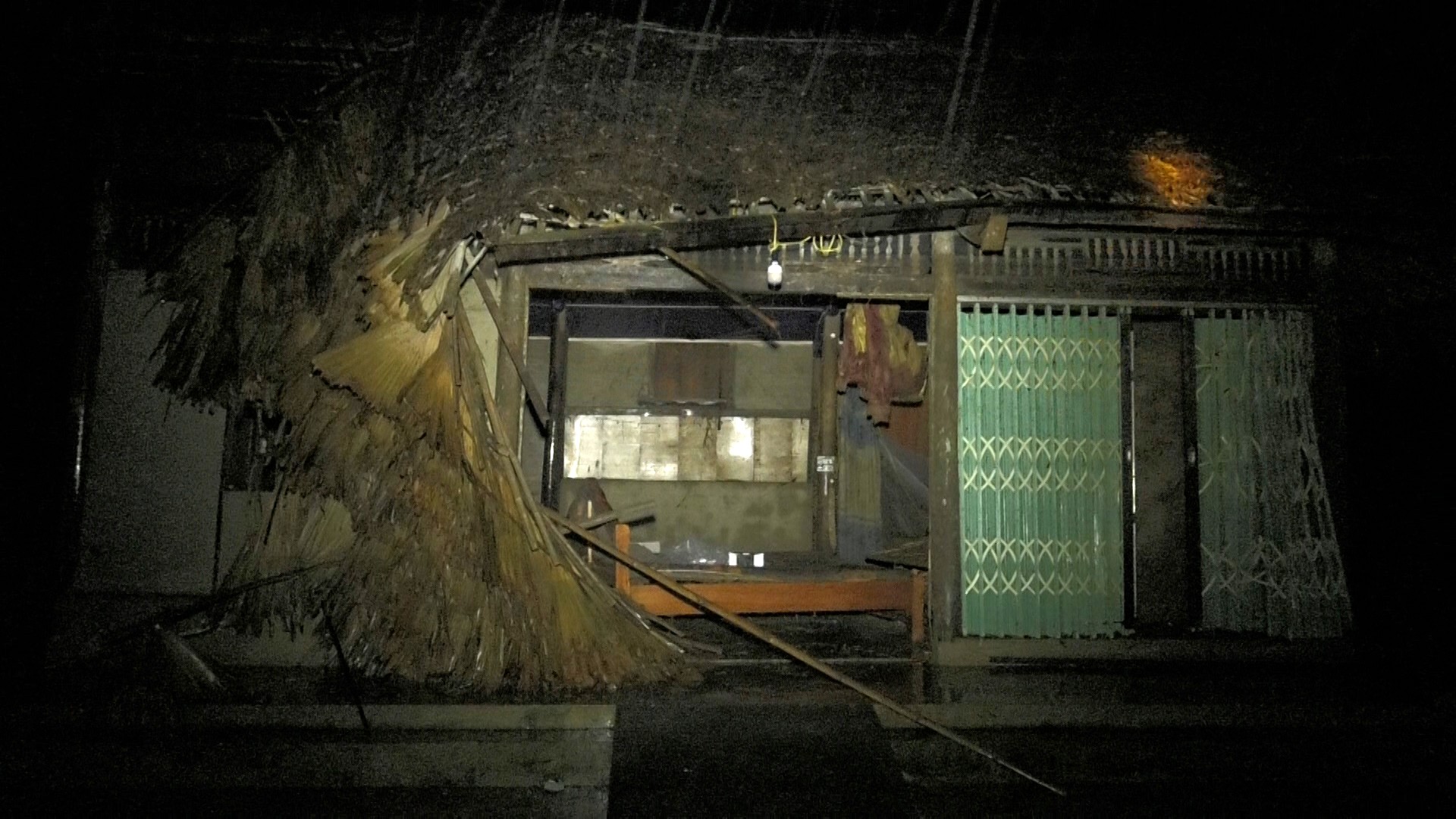
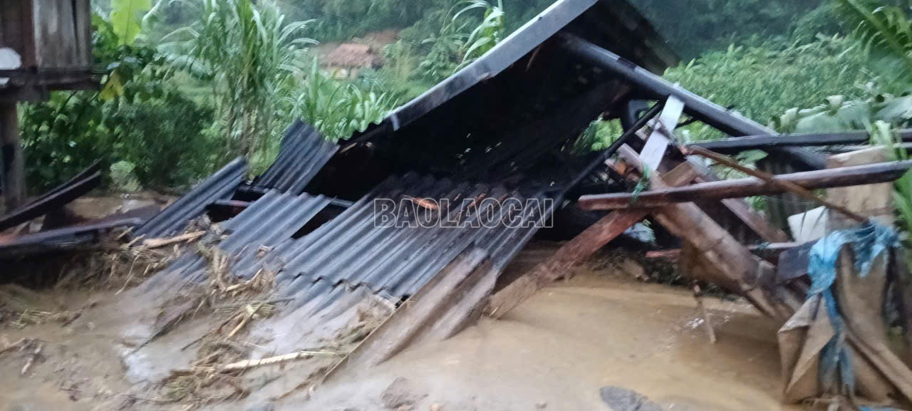
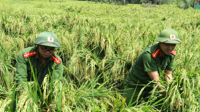
Right after the flood on the evening of September 29 swept through Ban Ben village, Viet Hong commune, we arrived at one of the areas heavily affected by storm No. 10 (Bualoi). Before our eyes was a tragic scene: roofs submerged in water, vast white fields, mud covering the roads.
According to preliminary statistics, the whole commune had 45 houses flooded, 68 households had their slopes eroded, 3 houses had their roofs blown off, more than 91 hectares of rice, 40 hectares of fish ponds were buried and over 4,000 livestock and poultry were swept away. Provincial Road 172 and many inter-commune roads were eroded, thousands of cubic meters of earth and rock, traffic was temporarily cut off.
Mr. Nguyen Van Ngoc, a resident of Ban Ben village, was drenched in rainwater with red eyes, pointing at the devastated house of his brother and sister and chokingly said: "The flood this afternoon started at around 3 o'clock, the strongest was around 4:30 to 5 o'clock. The water rose quickly, inundating the entire house... All property was considered a total loss."
The stories were filled with pain, but Mr. Ngoc's eyes still showed the resilience of a mountain people who are all too familiar with the harshness of nature.
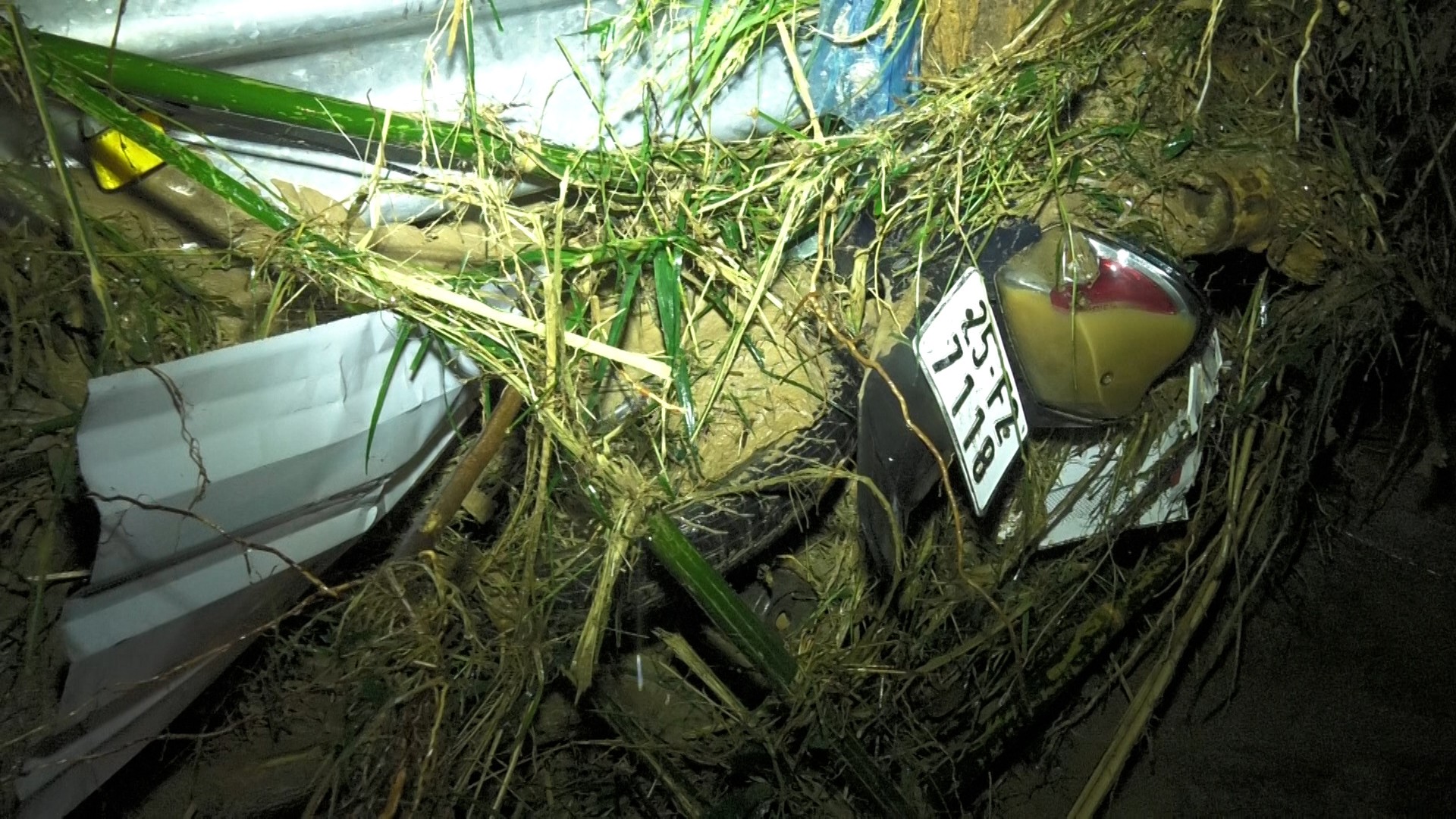

According to preliminary statistics, the whole commune had 45 houses flooded, 68 households had their slopes eroded, 3 houses had their roofs blown off, more than 91 hectares of rice, 40 hectares of fish ponds were buried, and over 4,000 livestock, poultry and many properties were swept away.
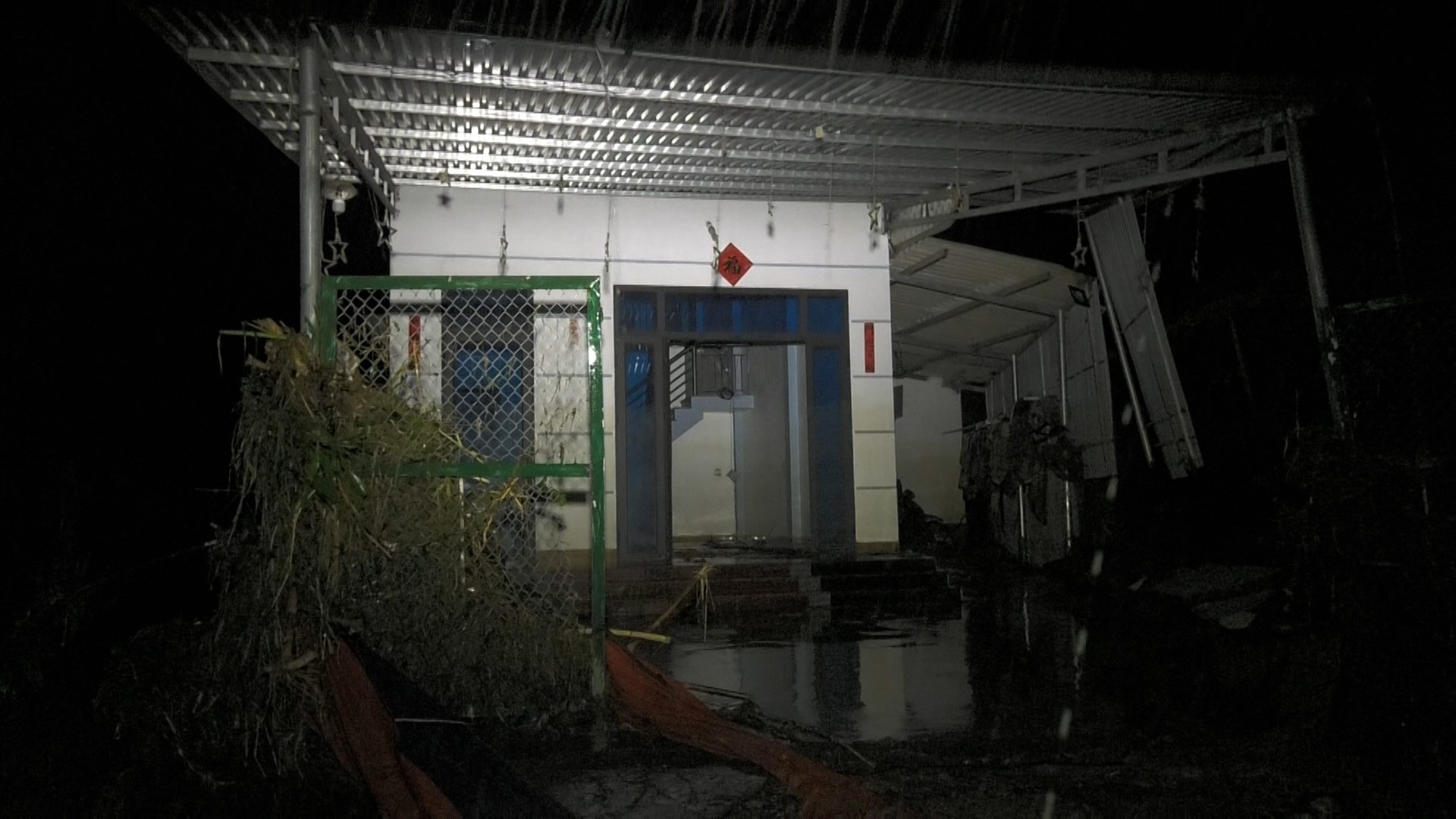
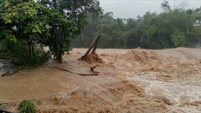
Floodwaters not only destroyed property and crops, but also directly threatened human lives. Within just 30 minutes, the water level rose from half a meter to over 1 meter, then quickly reached 3 meters. Faced with this situation, the Party Committee and government of Viet Hong commune immediately activated the "4 on-site" plan, mobilizing hundreds of cadres, police, militia and people to organize the evacuation of people from the danger zone.
Mr. Hoang Anh Tham, Commander of the Military Command of Viet Hong Commune, shared: "The water rose incredibly fast. At first, it was only about 50 centimeters above the road, but after only half an hour, it was over 1 meter, and then 1 hour later, it was 3 meters. We had to mobilize all militia and security forces to coordinate with the people to move their belongings and evacuate them to safety. This was truly a race against the floodwaters."

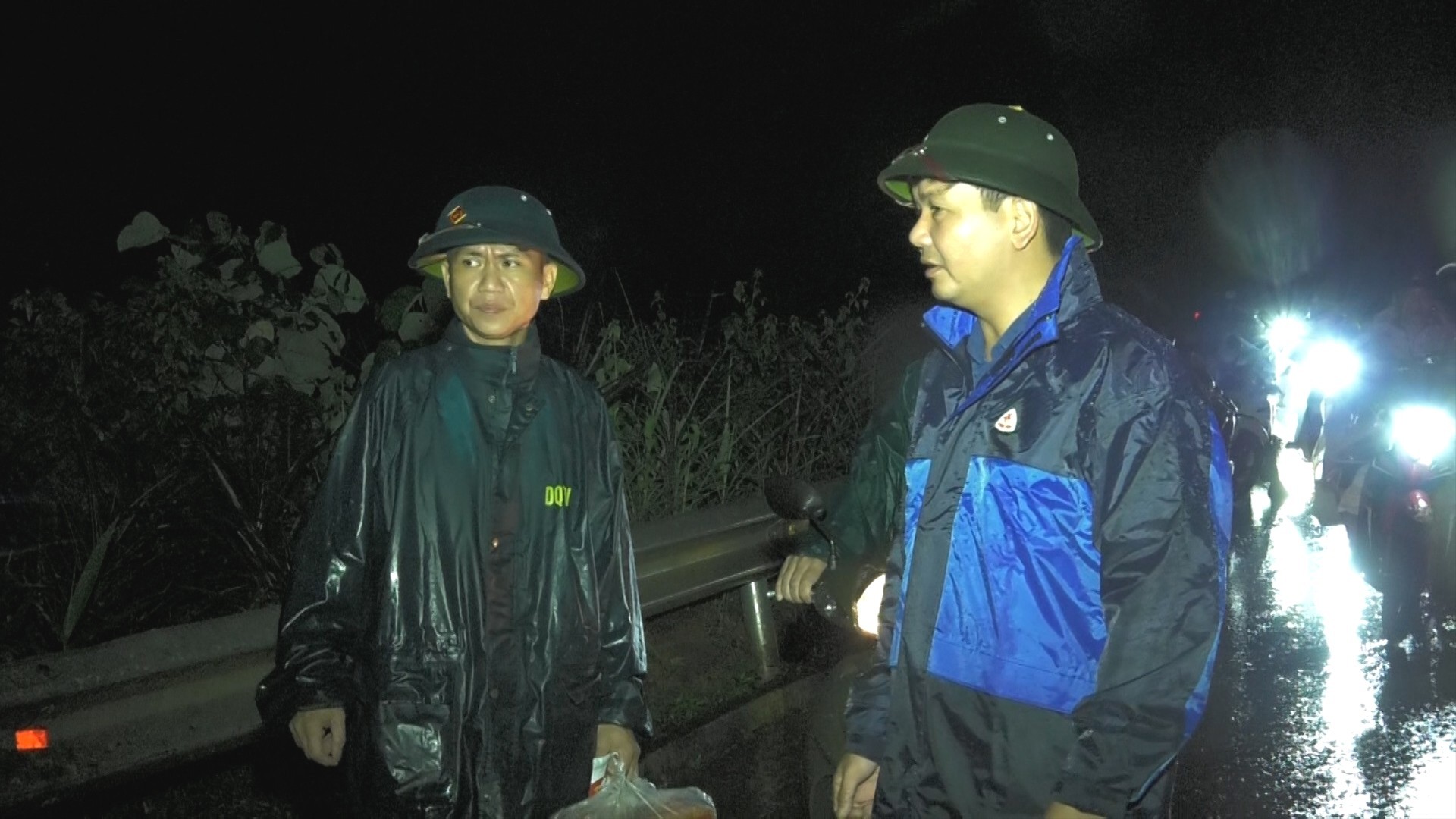

Leaders of Viet Hong commune and forces inspected the damage and supported people to overcome the consequences of natural disasters.
By 5 p.m. the same day, the commune had promptly evacuated 79 households with 278 people out of the danger zone. Families in vulnerable areas, at risk of landslides and flooding, were also resolutely evacuated, ensuring absolute safety for people.
Not only stopping at evacuating people, Viet Hong commune also proactively arranged forces on duty 24/7, prepared food, necessities and rescue vehicles. The spirit of "leaving no one behind" spread in every action.
Mr. Nguyen Tien Chien, Chairman of the People's Committee of Viet Hong Commune, affirmed: "We are still mobilizing local forces to support affected households. The number one goal is to ensure the safety of people's lives, followed by quickly stabilizing their housing. The commune will continue to work with other forces to support people in overcoming the consequences of storms and floods, helping people to soon stabilize their lives." Urgent and decisive direction; smooth coordination between the government and people has contributed to minimizing damage.
According to forecasts, the circulation of storm No. 10 is still complicated, with a high risk of prolonged heavy rain, landslides and flooding in the area. Therefore, the Viet Hong commune government continues to strengthen propaganda and warnings to each household, raising awareness and vigilance, absolutely not being subjective. On the roads, militia and youth union members are still on duty, ready to block at key points. In the villages and hamlets, loudspeakers are regularly broadcast, updating the latest information on the flood situation. In each house, people urgently brace the corrugated iron roof, raise furniture, and prepare for all situations.
Natural disasters have been testing the endurance of the Vietnamese people. But in difficult times, the image of people, officers and soldiers rolling up their pants, braving the rain to rescue and evacuate every small asset, every chicken, every pig... has further highlighted the solidarity, resilience and spirit of overcoming difficulties.
In Viet Hong, storms can destroy houses and crops, but they cannot break the will. The government and people here are working together every hour and every minute to overcome the consequences and stabilize life after natural disasters.
Information from Lao Cai Province Hydrometeorological Station (at 6:00 a.m. September 30) on the Red River is as follows:
At Lao Cai hydrological station, the flood on the Red River has peaked at 83.44m, 0.06m below alert level 3.
At Yen Bai hydrological station, the water level at 6am was 34.25m, 2.25m above alarm level 3. The flood continued to rise slowly, compared to 5am, the water level was 7cm higher.
 peaked at 83.44m.")
On the night of September 29, upon receiving information that a group of 17 Taiwanese tourists were stranded due to floods, the Department of Culture, Sports and Tourism of Lao Cai province directed Ta Phin commune to urgently provide support.
 guests were supported with food and accommodation.")
Taiwanese (China) guests were supported with food and accommodation.
The group of tourists was stuck in Trung Chai area, on the Lao Cai - Sa Pa route, due to heavy rain causing traffic congestion, unable to move for 5 hours. Local forces and people provided temporary meals and arranged safe overnight accommodation at a local school. On the morning of September 30, Ta Phin commune continued to supply food to the group.

Hotels in Sa Pa ward announced free accommodation for guests to avoid floods.
At the same time, many hotels and restaurants in the area also announced that they were ready to welcome stranded residents and tourists to avoid the flood for free.
Information from Lao Cai Province Hydrometeorological Station (at 11:00 p.m. on September 29) on the Red River is as follows:
- At Lao Cai station 82.21m, on BĐ2 is 0.21m;
- At Yen Bai station 33.13m, on BĐ3 is 1.13m.
.")
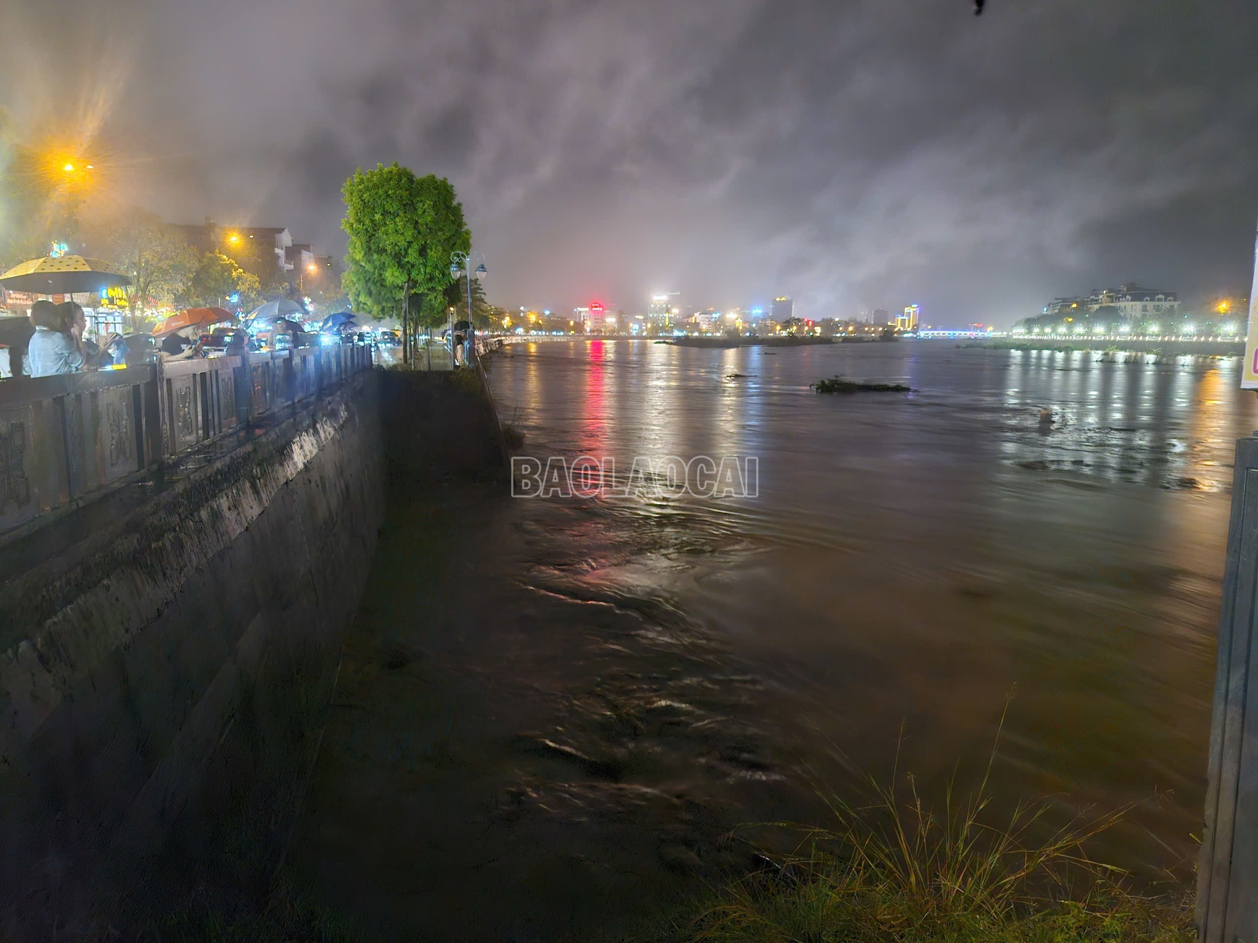
Red River flowing through Lao Cai ward (photo taken at 10:30 p.m. on September 29).
Forecast:
In the next 6 to 24 hours, floods will continue to rise due to the impact of heavy rain combined with flood discharge regulation of upstream reservoirs.
The peak flood level on the Red River at Yen Bai station is likely to reach 34.30m, on BĐ3 it is 2.30m; at Lao Cai station the peak flood level is 83.00m, on BĐ2 it is 1.00m.
Warning of flood risk and possibility of other natural disasters.
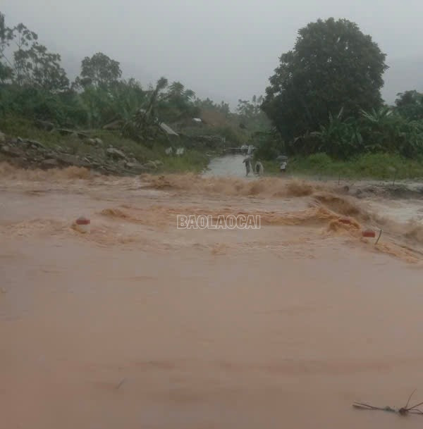
On the evening of September 29, in Tran Yen commune, there was prolonged heavy rain, combined with upstream floods, causing the water level of the Red River to rise rapidly, inundating many houses.

Police force stretched rope to warn of flooded areas.
As of 11 p.m. on September 29, the Red River water level was at 32.93 meters, 3 to 93 centimeters higher than the warning level. The flood caused many roads to be cut off, and many households in low-lying areas were inundated and isolated.
Tran Yen Commune has continuously issued notices and warnings to the people; at the same time, mobilized the police force, militia, shock troops, and village chiefs to organize the evacuation of people and property in areas at high risk of flooding and landslides to safe places. Local authorities require people to absolutely not stay on boats, rafts, or camps along rivers, streams, or areas at risk of deep flooding and landslides.

Commune police support people to move property.

People proactively moved their belongings and evacuated urgently that night.
According to initial statistics, on the night of September 29, hundreds of households, with thousands of people in the villages of Co Phuc, Thanh Thinh, Bao Dap and Tan Dong had to be urgently evacuated.
In addition, Tran Yen commune also deployed forces to be on duty at underground points, spillways and flooded areas, resolutely not allowing people and vehicles to pass through until safety is ensured. The government continues to direct villages to regularly update natural disaster developments to promptly respond and minimize damage.
Due to prolonged heavy rain, on the evening of September 29, on National Highway 4D from Lao Cai ward to Sa Pa ward and Lai Chau province, a sudden flood appeared on Ngoi Dum stream, inundating two sections of road in Lao Cai ward and Coc San commune, causing traffic congestion.

To ensure the safety of the people, the authorities quickly checked and placed traffic safety warnings in the flooded area, avoiding possible unfortunate consequences.
As of 11:35 p.m. on September 29, the flooding on National Highway 4D has not yet receded, causing local congestion. Authorities recommend that people choose routes that ensure safety for people and vehicles.
Due to the complicated weather situation, on the afternoon of September 29, Tram Tau High School arranged safe accommodation for more than 100 students.
Due to prolonged heavy rains, many landslides have appeared on inter-village roads in Hanh Phuc commune, and many culverts have overflowed. To ensure the safety of students studying at the school from afar, Tram Tau High School has checked students renting accommodation outside the school area and students going home during the day, from which a plan has been made for students to stay at school.

Accordingly, the school has moved all students from remote villages who are currently renting accommodation in houses outside the school area and students from Ban Hat and Ban Luu villages to live together in the school's boarding area (the school's boarding area currently has 200 students). Along with that, the school has increased the number of teachers on duty at the school to ensure the safety of the students during the rainy and flood days.
On the evening of September 29, Tram Tau High School reported to the Department of Education and Training about the flood situation in the area and proposed a plan for the entire school to be off tomorrow, September 30. In the following days, depending on the weather conditions, the school will arrange for students to return to school as usual.
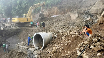
Due to the influence of storm Bualoi, on National Highway 279, km78 in Bong 3 village, Bao Ha commune, a landslide occurred from the positive slope to the road surface, causing congestion and making it impossible for vehicles to move. Currently, the entire road from the top of Bao Ha slope along both sides of the steep pass is at high risk of landslides, especially when heavy rain lasts for a long time.
Bao Ha Commune Police advise people not to travel through the above area to ensure safety of life and property. People are requested to follow warning information, proactively prevent and absolutely not be subjective.
From 1:30 p.m. to 11 p.m. on September 29, Phuc Khanh commune experienced prolonged heavy rain, increasing the risk of landslides and flash floods in many areas. Currently, the amount of rain is still very heavy, the stream water is rising, posing many potential risks.

Propaganda and mobilize people to evacuate to safe places.

On-site forces of Phuc Khanh commune urgently cleared fallen trees and cleared National Highway 70.
Faced with complicated weather conditions, the People's Committee of Phuc Khanh commune urgently reviewed and identified 50 locations at high risk of landslides with 196 households needing urgent evacuation.
The Commune Steering Committee for Natural Disaster Prevention, Control and Search and Rescue directly directed and mobilized local forces to coordinate with villages and hamlets to propagate and encourage people to leave dangerous areas at night, ensuring safety of life and property.

Phuc Khanh commune authorities supported households in evacuating their property that night.

Many households in areas at high risk of landslides were evacuated to safe shelters.
Along with that, the commune's functional forces have increased patrols, been on duty 24/24 hours, arranged vehicles and human resources ready to respond to emergencies; coordinated with relevant units to closely monitor weather developments to promptly warn people.
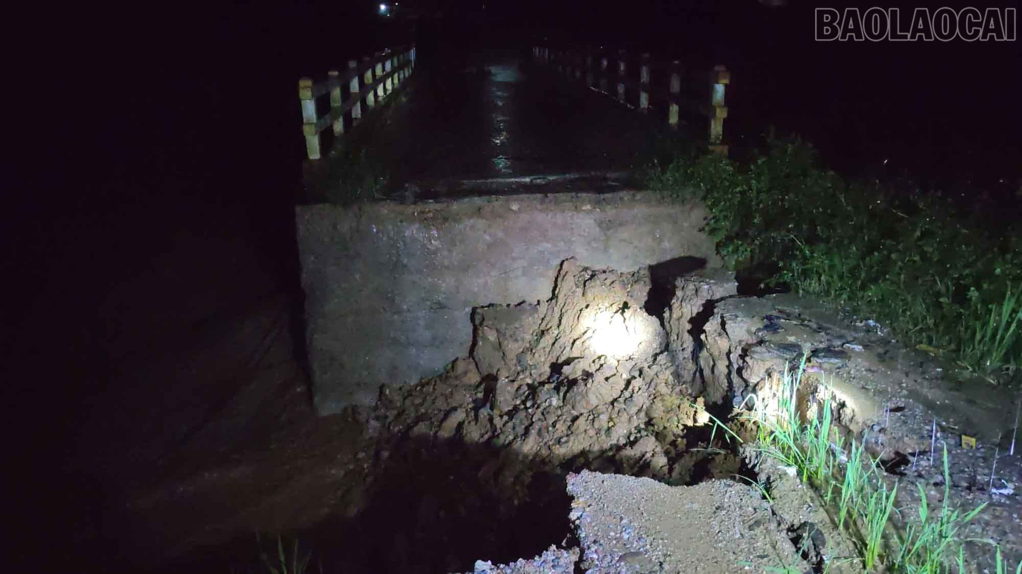

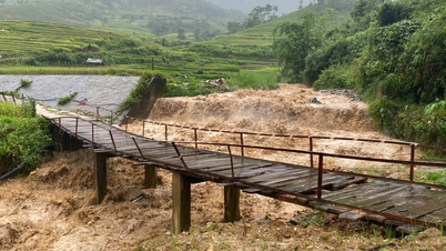
The bridge to Lang Dau village has both ends of the bridge abutments washed away and is currently impassable.
From the afternoon of September 28 to 29, in Ban Lau commune, there was moderate rain, accompanied by strong gusts of wind, causing damage to people's property, crops and public works in the area.

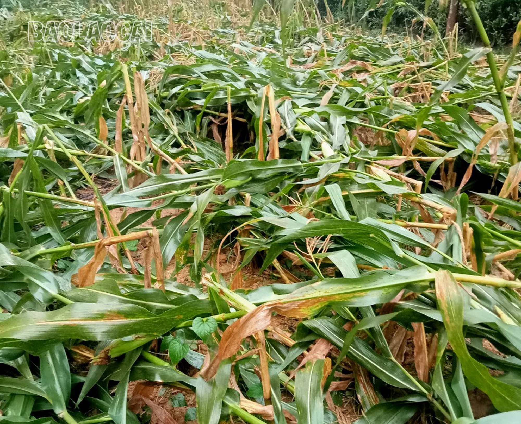

Dozens of hectares of crops in Ban Lau commune were broken.
As of 8:00 p.m. on August 29, floods had damaged 8 houses in Ban Lau commune, of which 2 houses were damaged over 70%, 6 houses were damaged under 30%.
About 55 hectares of crops were damaged, including 16.48 hectares of rice, 29.94 hectares of corn, 3.5 hectares of bananas, 1.5 hectares of cassava, and 1.5 hectares of linden trees.
The flood also caused a tree to fall on the power line of Na Ma 1 village; collapsed 2 meters of fence, and broke the flagpole of the Cultural House of Na Lang village...
Total damage is estimated at about 2.56 billion VND.

Floods damaged eight houses in Ban Lau commune.
It is known that the People's Committee of Ban Lau commune has thoroughly disseminated to all cadres, civil servants, and public employees of agencies, units, and comrades, Party cell secretaries, and heads of villages and hamlets the directive documents of the Central and the province on responding to storm No. 10. Assigned specific tasks to members of the Steering Committee for Natural Disaster Prevention, Search and Rescue and Civil Defense to organize 24/24 hours on duty to promptly handle possible natural disaster situations according to the motto "4 on-site".
For houses with blown-off roofs, the People's Committee of Ban Lau commune mobilized forces to support households in re-roofing their houses to stabilize their lives.
Currently, on the Yen Vien - Lao Cai railway line, the section passing through Lao Cai province (from Yen Bai station to Lao Cai station), there are many deeply flooded points, with water on top of the rails ranging from 200 - 300 mm. At the same time, there are many points where the negative and positive slopes have collapsed. To ensure train safety, Yen Lao Railway Joint Stock Company has closed the road at flooded and landslide points.
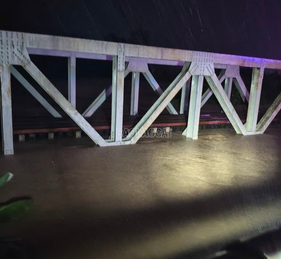
Nga Quan Railway Bridge.
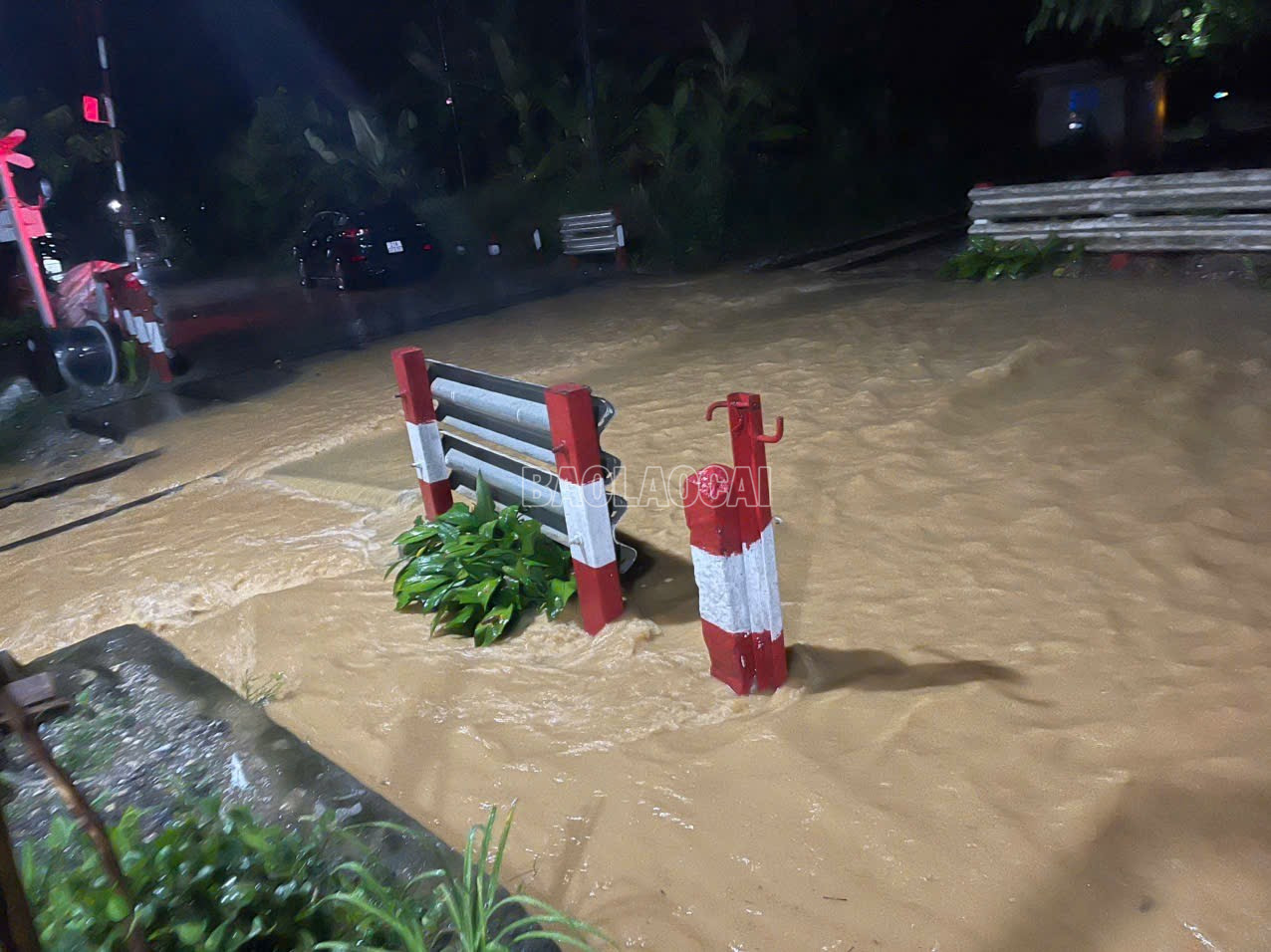
Crossroad Km148 + 003 (Yen Vien - Lao Cai railway), section through Lao Cai province.
According to Lao Cai Hydrometeorological Station, the Red River water level is currently rising: Accordingly, at 9:00 p.m. on September 29, in Yen Bai ward, the Red River water level reached 32.04 m (0.04 m above alarm level 3). The river water level is forecast to continue to rise to 33.8 m.
The flood peak of storm number 3 Yagi is 35.73m (for people to easily compare and proactively evacuate to a safe place).
Rising river water levels can cause flooding in low-lying areas along the river. In addition, due to the impact of heavy rain with high intensity, there is a high risk of flooding in some communes and wards: Lao Cai Ward, Cam Duong, Muong Khuong Commune, Luc Yen Commune, Muong Lai Commune, Phuc Loi Commune, Tan Linh Commune, Yen Binh Commune; Yen Bai Ward, Au Lau, Nam Cuong, Van Phu and Tran Yen Commune, Xuan Ai Commune, Mau A Commune with a depth of 0.3 - 0.5m, in some places over 1.0m.
As of 10:19 p.m. on September 29, in Van Ban commune, the circulation of storm No. 10 (Bualoi) continued to cause heavy rain.
According to information from the People's Committee of Van Ban commune:
- Human damage: not recorded.
- Isolated villages: Lang Chut, It Noc, Na Loc 2 and Thai Hoa.
- Hydroelectric projects: 2 hydroelectric plants in the area had to temporarily stop operations to ensure safety.
- Irrigation works: 1 regulating work was broken.
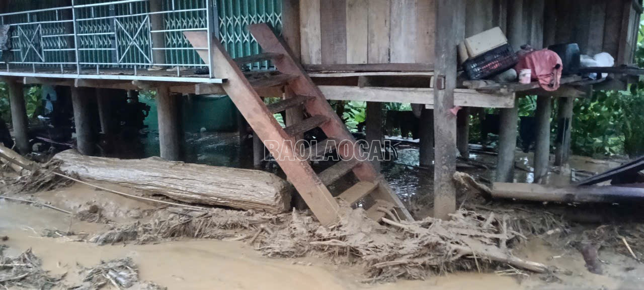
- Housing: More than 10 houses were flooded, 2 were completely swept away.
Heavy rain during the night cut off many roads, making rescue operations difficult. Police, militia and commune officials are urgently assisting in evacuating people from dangerous areas.
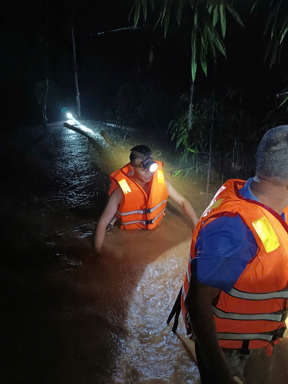

Rescuers brought people to safety.
Van Ban Commune authorities said they are continuing to coordinate with functional forces to evacuate people to safety, while closely monitoring the development of rain and floods in the coming hours.
Due to the impact of storm No. 10, the water level of Ban Tat stream rose, making it impossible for many parents of Na Hau Kindergarten, Tan Hop commune, to pick up their children. Up to now, 44 children have to stay at school.


Ms. Pham Thi Thanh, Principal of the school, said: “In the face of the complicated flood situation, the Board of Directors organized cooking at the school; at the same time, assigned teachers and staff to be on duty and take good care of the children's meals and sleep. This is not only a professional responsibility but also shows the love of the school's staff, teachers and employees for the children."
At about 7:50 p.m., a landslide occurred at Km144 in the O Quy Ho Pass area of Sa Pa Ward. When the landslide occurred, many vehicles were parked below. The landslide damaged several cars, and people and passengers fled in panic. Fortunately, no casualties were reported. Currently, dozens of people and vehicles are isolated at Km144 because both ends were affected by landslides.
According to the Sa Pa ward authorities, currently on National Highway 4D from Sa Pa ward to O Quy Ho pass, there are many landslides causing traffic congestion, making it difficult to move and access the area where the vehicle had an accident.


It is known that the functional forces of Sa Pa ward are also coordinating with relevant units to urgently fix landslides and bring people in dangerous areas to safety.
From noon on September 28 to afternoon on September 29, in Khanh Yen commune (Khanh Yen Ha commune, Liem Phu, old Van Ban district), there was heavy rain, sometimes accompanied by strong gusts of wind, causing damage to many properties, crops of households and traffic works, irrigation, domestic water supply, electricity, and telecommunications.
The floods forced 23 households to evacuate urgently, 2 households were submerged. The area of rice fields and crops damaged was about 75 hectares; of which 65 hectares of rice (damage level over 70%) and 10 hectares of corn.
Since the evening of September 29, the culverts and road crossings have been deeply flooded, causing traffic disruption in some villages. In addition, the road to Na Nheo village has been eroded at 3 points, estimated to be about 70m long, with a volume of earth and rock of 250m3 .
In Lam Sinh, Liem, and Giang villages, some sections of the centralized water supply pipeline were swept away by floodwaters, affecting the water supply to over 100 households and schools.
The total estimated damage caused by floods on September 29 is about 2.5 billion VND.
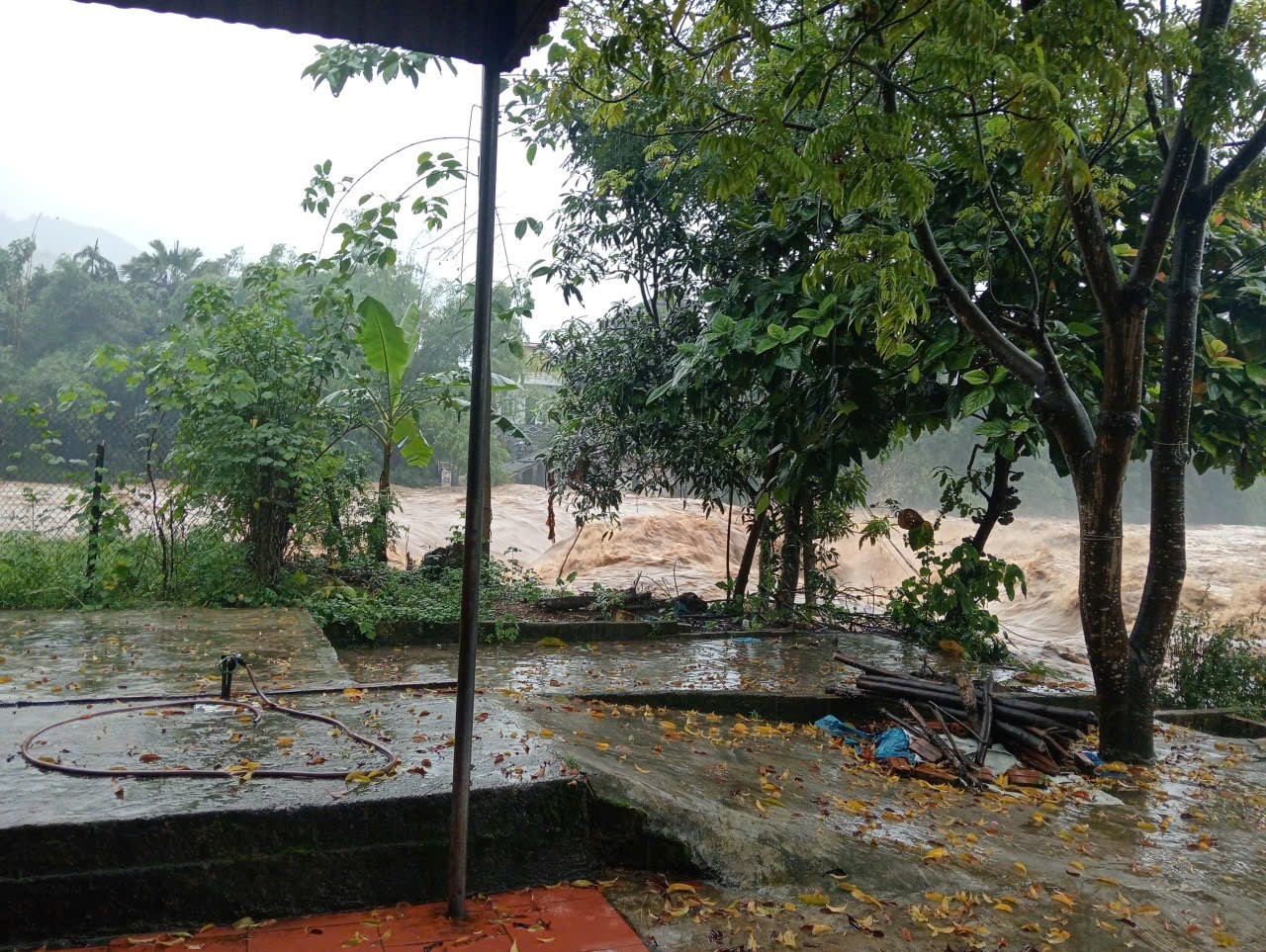
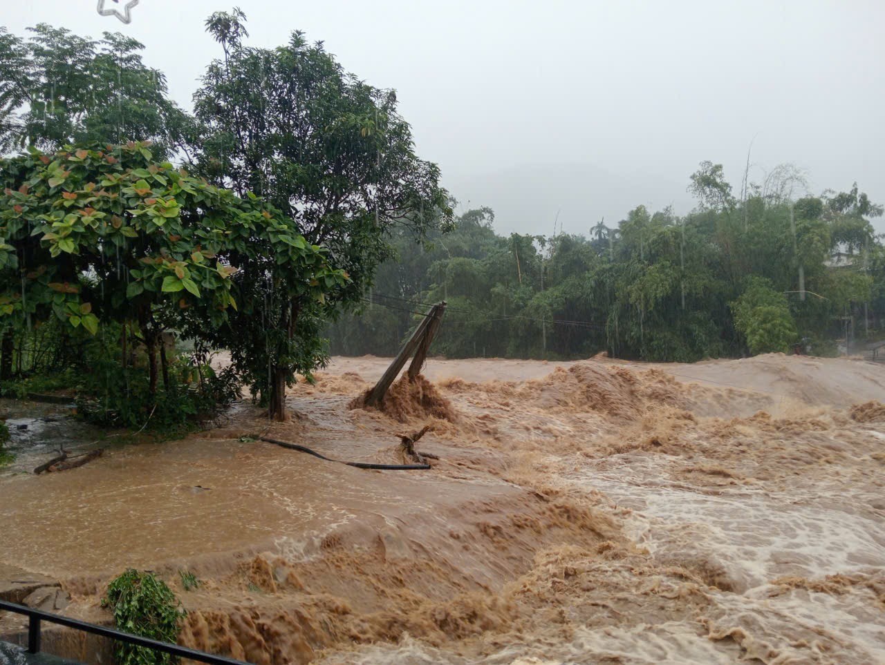
On the night of September 28 and 29, in Phong Du Ha commune, thunderstorms and prolonged heavy rains caused the water level of streams, especially Ngoi Hut stream, to rise, flooding people's houses and crops.

Heavy rain caused localized flooding in some areas in Phong Du Ha commune.
Due to the impact of floods, 15 houses in Phong Du Ha commune had their roofs blown off; 19 hectares of rice and corn were damaged; 6 electric poles were broken. Due to the rapid and high water level, some villages such as Ngan Vang, Trung Tam, Khe Hao, Khe Kia, Khe Lau were isolated. To ensure the safety of people's lives and property, the commune evacuated 70 households at risk of flooding and landslides to safe places. As of 10 p.m. on September 29, the initial damage caused by storm No. 10 in the commune was about 500 million VND.
Currently, the commune has mobilized a local force of about 350 people on duty 24/7 in the villages to promptly respond and help people overcome the damage.
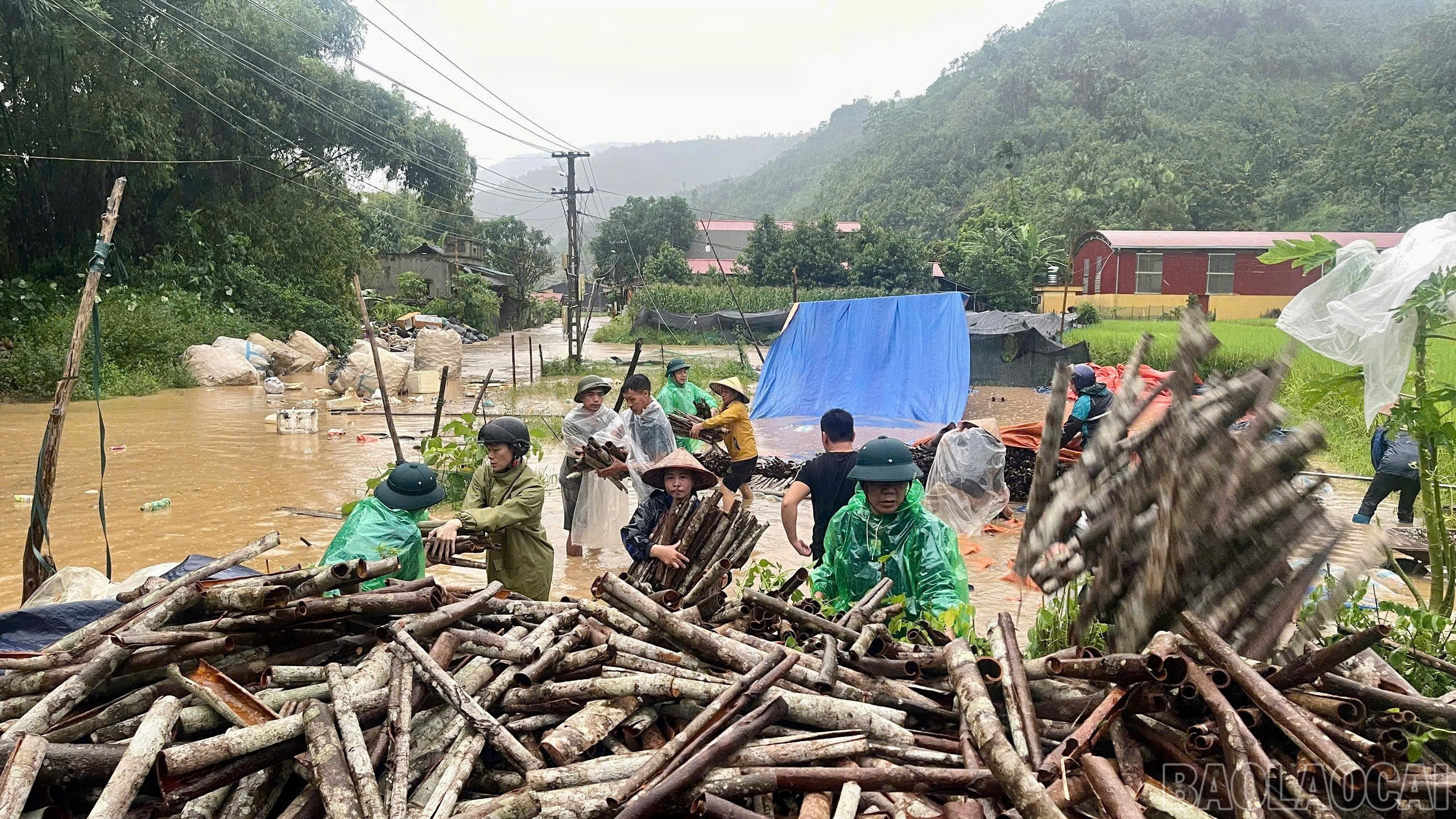
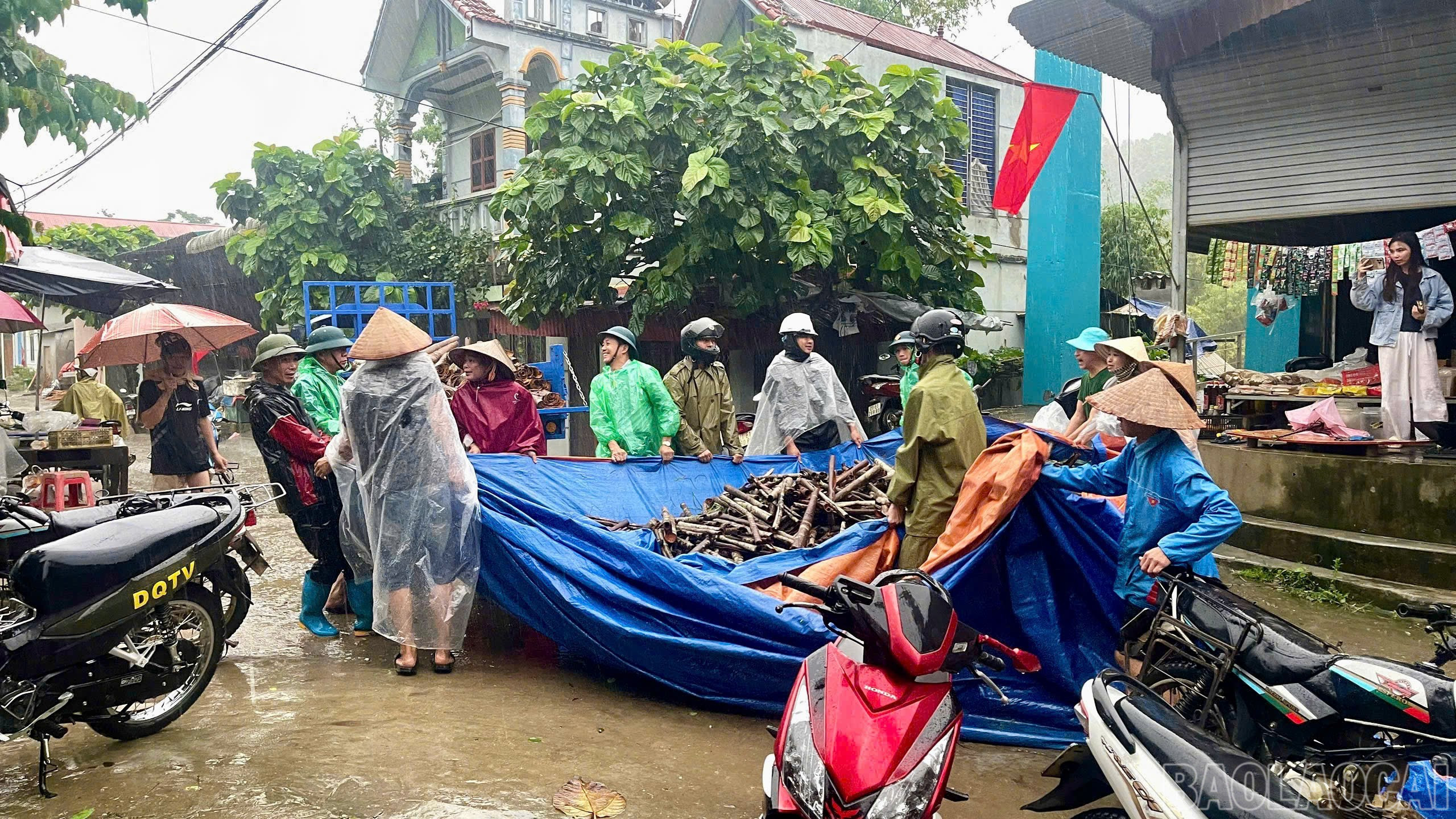

Forces support people to move cinnamon out of flooded areas.

Move belongings of families at risk of flooding to safety.
Phong Du Ha is the province's cinnamon hub. It is currently the cinnamon bark harvest season, but the rain and floods have risen rapidly, and people have not had time to transport them to higher ground, causing dozens of tons of cinnamon bark to be submerged in water.

Leaders of Phong Du Ha Commune People's Committee inspected the actual damage at people's houses.
Storms and floods also caused the commune's power grid to be cut off for many hours. In the face of natural disasters, the Phong Du Ha commune government urgently deployed a "four-on-the-spot" plan to support the relocation of assets and ensure the safety of people. On the night of September 29, the commune evacuated 64 households that were flooded and at risk of landslides.
Due to the influence of storm No. 10, there is heavy to very heavy rain in Phong Du Thuong Commune.

Due to prolonged heavy rain, by the afternoon of September 29, 8/8 villages in Phong Du Thuong commune, including Lang Than, Ban Lung, Khe Det, Khe Tau, Cao Son, Thuong Son, Khe Mang and Trung Tam were isolated. Dong An - Gia Hoi road running through the commune had many landslides and was impassable. Currently, Ngoi Hut stream is rising higher than Ngoi Hut 1 hydroelectric dam by more than 4m, the whole commune has completely lost power.
Faced with the complicated weather, the commune has also asked people in areas at high risk of landslides to move to safety. However, the road from the commune center to the villages is currently flooded, making it difficult to travel. In addition, due to widespread power outages, it is very difficult to count and overcome the damage.
In Duong Quy commune (former Van Ban district), since the night of September 28, there has been continuous moderate to heavy rain, causing major floods in many streams and creeks. The rising floodwaters have affected 7 households, 7 households had to be urgently evacuated; many rice fields were heavily flooded; many structures were damaged. The initial damage is estimated at about 500 million VND.
Specifically, 6 houses were affected by over 70% damage, 1 house was damaged by less than 30%. The flood also caused 15 hectares of rice ready for harvest to be flooded, 19 hectares of crops to be broken.
Heavy rains also caused damage to many traffic works. The road in Nam Mien village had a positive slope landslide, the volume of landslide was estimated at 100m3 . The road in Tham Con village and Nam Hoc village had many landslides and is currently impassable, so we have not been able to access it to estimate the damage in detail.
On Highway 279, Nam Cho overflow tunnel is currently flooded, water flows rapidly, and traffic cannot pass. The Commune People's Committee has directed the commune police force to put up warning ropes and be on duty to prevent people from passing through.
In addition, Tham Duong Kindergarten also suffered a negative slope landslide that could affect the student kitchen, restrooms, two functional rooms, and three households below. The storm also caused three electric poles to fall, and one electric pole is at risk of falling.
Estimated damage caused by floods in Duong Quy commune is about 500 million VND.
Due to the impact of storm No. 10, heavy rains have occurred in Hanh Phuc and Tram Tau communes, causing damage to houses and roads.


According to the report of Hanh Phuc commune and Tram Tau commune, by 3:00 p.m. on September 29, 26 houses of people were affected (21 houses in Hanh Phuc commune, 5 houses in Tram Tau commune). The affected houses were mainly damaged by landslides with a volume of tens of cubic meters. Immediately after the flood, the functional forces of the two communes quickly arrived to help people overcome the consequences, evacuate property and people to safe places.
Particularly on Provincial Road 174 from Nghia Lo ward to Hanh Phuc commune, there have been many landslides, including 3 landslides with large volumes of rock and soil causing traffic congestion.
Due to the impact of storm No. 10 Bualoi, on the evening of September 29, Van Chan commune experienced prolonged heavy rains, causing flooding and landslides in many areas. The commune People's Committee organized the emergency evacuation of 30 households in the dangerous area to a safe place.

Some traffic routes in the commune were also flooded locally such as Km185+200, National Highway 32, Van Thi 4 - Phu Nham village road, Ba Cau village road, Kang Ky - Suoi Lop village road, Thac Hoa 3 village road... In addition, about 20 village and inter-village roads were eroded with a total volume of rock and soil estimated at about 150 m³, hindering people's travel.

Currently, the Van Chan commune government continues to mobilize local forces, coordinate with functional units to be on standby to respond, ready to evacuate more households if necessary and deploy measures to ensure people's safety while heavy rain continues.
Huyen Thuong
News reporter group
Due to the impact of storm No. 10 (Bualoi) causing prolonged heavy rain, from 6 p.m. on September 29, on National Highway 4D, the section from Lao Cai ward to Sa Pa, many landslides appeared, causing traffic to be cut off. To ensure the safety of the people, the authorities have temporarily stopped the traffic on the route.

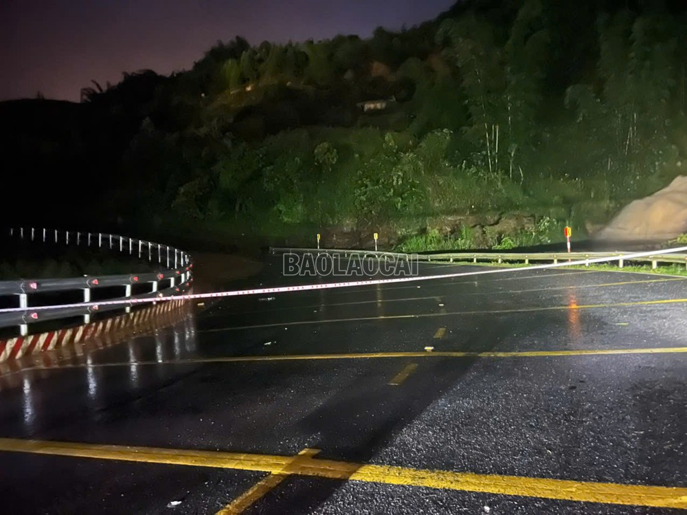
According to information from the authorities, there are currently at least two major landslides at Km 98+200 (Sa Pa ward) and Km 114 + 100 (Ta Phin commune). The volume of landslides cannot be counted due to heavy rain, darkness and the high risk of further landslides. In addition, many other small landslides have been recorded along the route.
That very night, Traffic Police Team No. 1 (Traffic Police Department, Lao Cai Provincial Police) coordinated with the road maintenance unit to urgently organize the stretching of ropes, place warning signs, and temporarily close the road at the IC19 intersection to Sa Pa and the opposite direction from Sa Pa to Lao Cai city.
The maintenance team has also mobilized machinery and equipment to be ready to deploy to fix the problem. However, due to heavy rain and complex terrain, the work can only be carried out when the weather is favorable, expected from the morning of September 30.
Currently, all vehicles from Lao Cai to Sa Pa and vice versa must be temporarily suspended. Residents and tourists are advised to absolutely not enter the National Highway 4D area at this time to ensure safety.
According to a report by Road Construction Joint Stock Company 1, due to prolonged heavy rain on National Highway 32 through the communes of Tu Le and Pung Luong, many landslides occurred, causing traffic congestion.
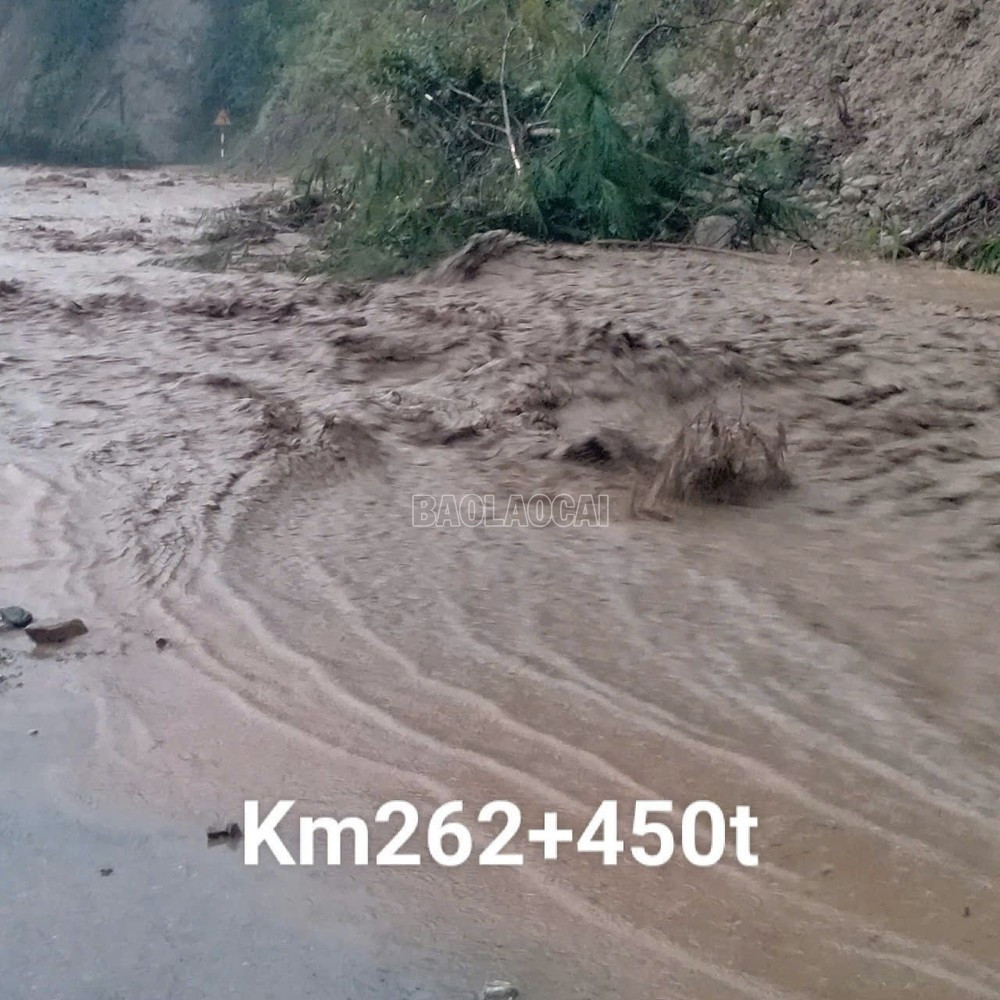
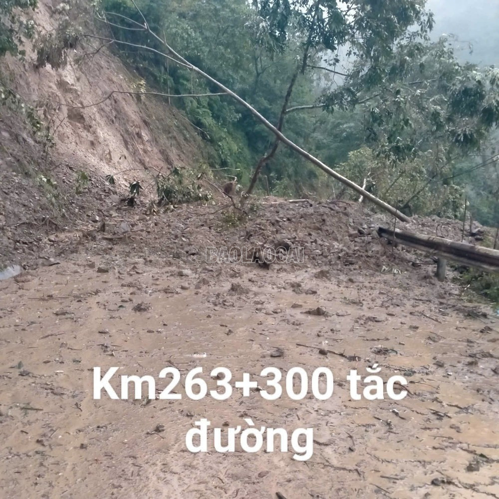
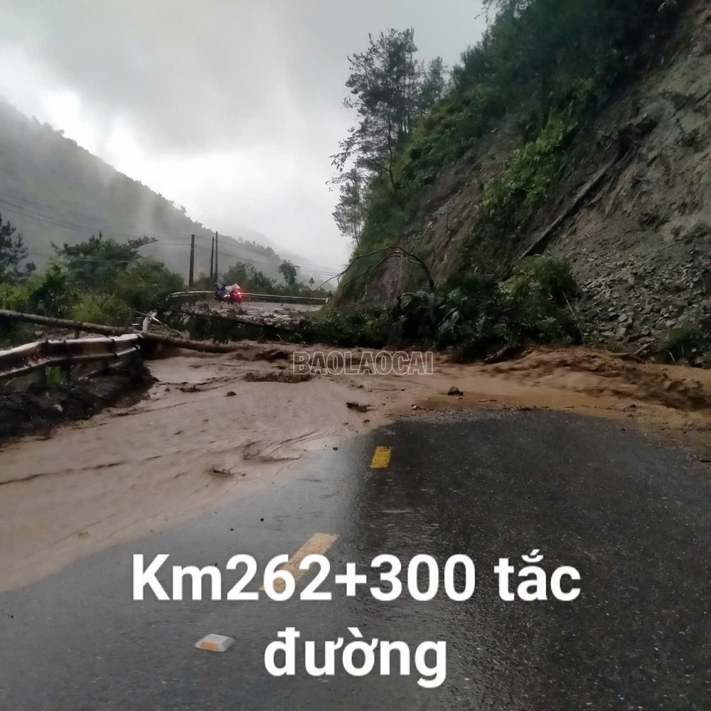
Specifically, at km 261 + 600, km 262 + 300, km 262 + 400, km 263 + 300 on Khau Pha Pass in Tu Le Commune and km 290 in Pung Luong Commune, landslides occurred with a large amount of rock and soil spilling onto the road, causing traffic congestion. Immediately after the landslide, Road Construction Joint Stock Company 1 mobilized machinery to clear the rock and soil, but heavy rain made this work difficult. Therefore, National Highway 32 is still blocked, vehicles cannot circulate, vehicles should pay attention to grasp information, comply with warnings and adjust directions appropriately to ensure safety for people and vehicles. Road Construction Joint Stock Company 1 is making efforts to clear this route as soon as possible./.
Due to the impact of storm No. 10, from the night of September 28 to September 29, Ta Xi Lang commune experienced heavy to very heavy rain with strong winds, with rainfall ranging from 216.6 to 270.8 mm. By the afternoon of September 29, the rain had not stopped, and the risk of landslides continued to increase. The commune's Steering Committee for Natural Disaster Prevention, Control and Search and Rescue has activated an emergency response plan, mobilizing local forces to be on duty 24/7 to ensure people's safety and minimize property damage.

According to preliminary statistics, heavy rains caused 3 households in Xa Nhu and Ta Dang villages to have rocks and soil from the slopes overflow into their houses. The commune government promptly mobilized the militia, commune police, and youth union members to urgently evacuate all the above households to temporary safe accommodation.
In addition, to prevent risks, 14 other households in areas with high risk of landslides were also urgently evacuated to safe areas in the commune. Local authorities have made a list, arranged essential supplies, and assigned forces to temporarily support the households.
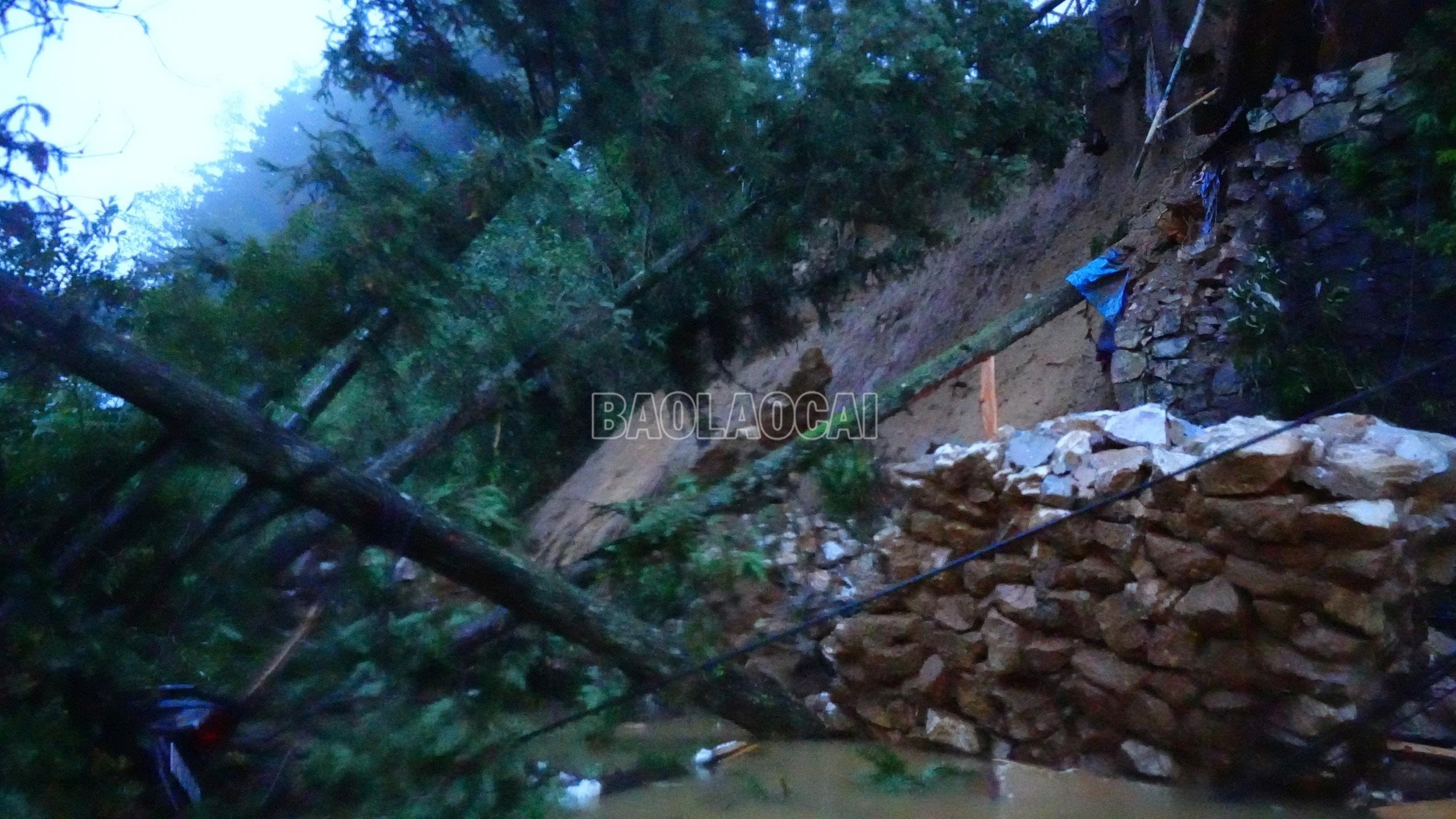
Heavy rain also seriously affected traffic. The road from Suoi Xuan to the Ta Xi Lang Commune People's Committee headquarters had a landslide at 6 points with a total volume of rock and soil estimated at about 1,500m³, causing the entire route to be temporarily cut off and traffic to stagnate. It is still raining heavily, making statistics and recovery work difficult. The commune government is coordinating with the district to mobilize machinery and vehicles to be ready to clear the route as soon as the weather permits.
Quick report from Muong Hum Commune People's Committee: On September 29, 2025, the commune recorded 1 case of missing people due to landslide.
Specifically, at about 3:45 p.m. on September 29, Ms. Giang Thi S., born on June 19, 1978, with permanent residence in Po Ho village, Muong Hum commune, on the way from her house to the shed to raise livestock, was hit by a landslide and went missing. Immediately after receiving the news, Muong Hum commune police advised the Standing Party Committee and the People's Committee of the commune to establish working groups and organize search and rescue. At 6:30 p.m. on September 29, the authorities were still trying to reach the scene to search for the victim, but due to heavy rain and dangerous landslides, the search and rescue work encountered many difficulties.
Due to the impact of storm No. 10, Muong Hum commune is still experiencing heavy rain, rising floodwaters, and a high risk of flash floods and landslides. The locality continues to mobilize forces to directly go to the grassroots to inspect and overcome the consequences of floods and storms, and move people in high-risk areas to safety.
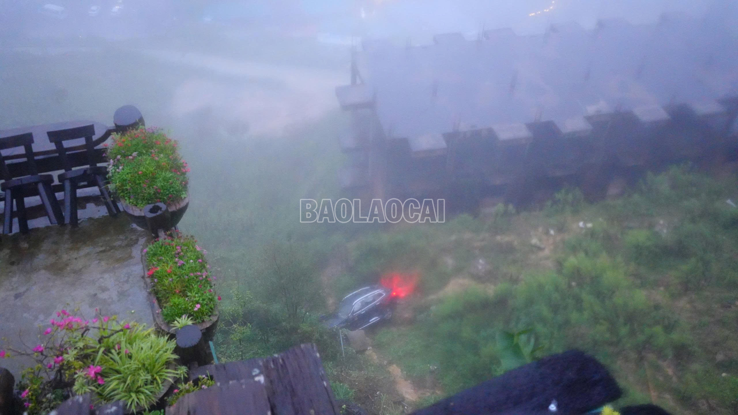
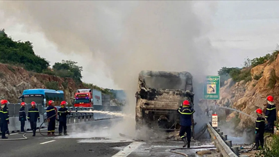
Due to the impact of storm No. 10, heavy rains occurred in Sa Pa ward, causing landslides in some areas. In particular, this afternoon, September 29, on DH92 road, Phan Si Pang group (from the center of Sa Pa ward to Cat Cat tourist area), a large landslide occurred, causing a car to be thrown into the abyss, fortunately there were no casualties.
Specifically, at about 5:10 a.m., in the above area, dozens of tons of rocks and soil suddenly collapsed onto the road. At this time, a 5-seat car moving from the direction of Cat Cat tourist area to the center of Sa Pa ward was crushed by rocks and soil, thrown into a deep abyss about 100m. Fortunately, the 3 people in the car only suffered minor injuries.
.")
Immediately after the incident, the People's Committee of Sa Pa Ward mobilized forces to direct traffic, not allowing people and vehicles to pass through, ensuring safety. The locality also mobilized machinery and vehicles to level the rocks and soil, ensuring the road was open to traffic as soon as possible.

According to records, there are currently many landslides in the area. The Ward People's Committee has urgently mobilized and evacuated people in dangerous areas to safe places. The authorities also continue to check areas at risk of landslides and floods to put up warning signs. According to statistics, in Sa Pa Ward, there are nearly 90 households, motels, and camps that need to be moved when storms occur, to ensure the safety of people and property.
Due to the influence of storm No. 10, since the morning of September 29, there has been prolonged heavy rain in Luong Thinh commune. Heavy rains have caused flooding in low-lying villages and landslides, damaging many properties and crops of the people.
As of 6 p.m. on September 29, the floods had destroyed the houses of two households in Yen Thinh village, knocked down a 35KV electric pole in Yen Ninh village and several low-voltage poles. In addition, the floods had isolated several villages such as Khe Ca, Phuong Dao 3, Tran Hung, etc.
To proactively respond and minimize damage caused by rain, floods, and landslides, the People's Committee of Luong Thinh commune has mobilized local forces and people to effectively implement the "4 on-site" motto to support affected households.
Due to prolonged heavy rain, major floods and localized inundation occurred in Cau Thia ward (old Nghia Lo town). According to statistics, the entire ward had to evacuate 90 households to a safe place. The floods also caused 100m of Nam To dike to break and 40m of Thia stream embankment in Na Duong residential group to be seriously eroded; the iron bridge to Ban Co residential group was eroded. The floods also broke 0.25ha of rice; estimated damage was about 100 million VND.


Immediately after the disaster occurred, the ward leaders were directly present at the scene, directed the evacuation work, mobilized local forces to support people to overcome the consequences, and at the same time continued to monitor and proactively take preventive measures to minimize damage caused by storms and rains.

Faced with the complicated developments and dangerous level of storm No. 10 (Bualoi), the police force of communes and wards in Lao Cai province has proactively deployed many measures to ensure the safety of people's lives and property, clearly demonstrating its core role in natural disaster prevention, control and search and rescue work in the locality.

Due to the impact of storm No. 10, heavy to very heavy rain occurred over a wide area in the province, landslides occurred in many localities, causing local traffic jams and potentially threatening people's lives.
In Sa Pa ward, the ward police mobilized 100% of its personnel to coordinate with the local security forces and local authorities to check each vulnerable area and assist people in evacuating to a safe place. By the afternoon of September 29, the ward police had coordinated to evacuate 16 households with 77 people to a safe shelter.

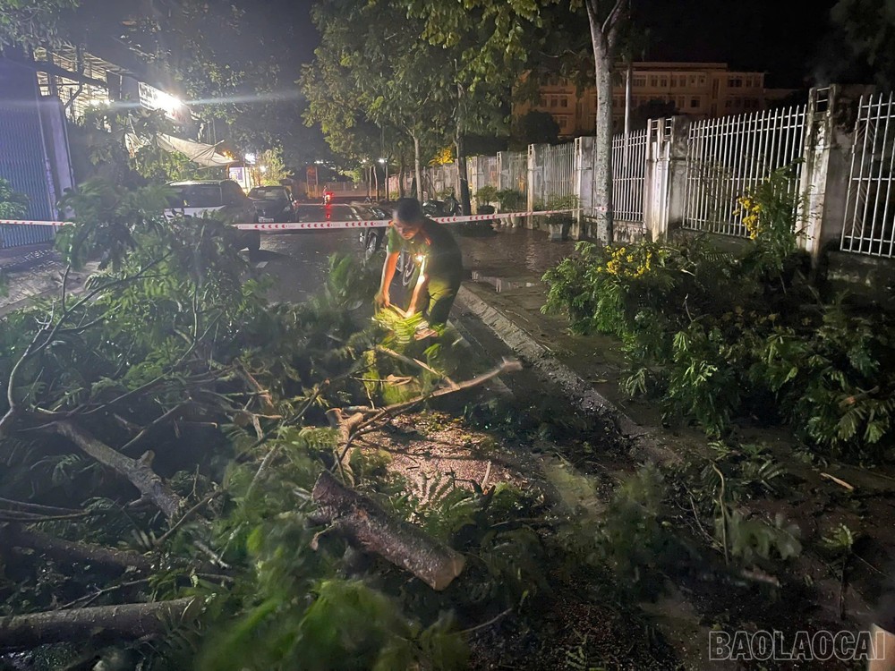

In addition, the police of communes and wards across the province strictly implemented the orders of the Provincial Police Director, arranged forces on duty 24/24, prepared rescue vehicles and materials; coordinated with the government, military forces, and youth unions to support the evacuation of people in dangerous areas to safety. At landslide sites and fallen trees, the police forces of communes promptly cleaned up and cleared the roads, ensuring smooth traffic.

Currently, Lao Cai province continues to experience heavy to very heavy rain, floodwaters in some rivers and streams are rising. Local police are urgently deploying response measures, ready to support people in emergency situations.
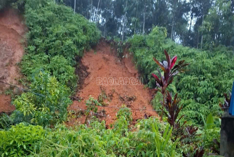
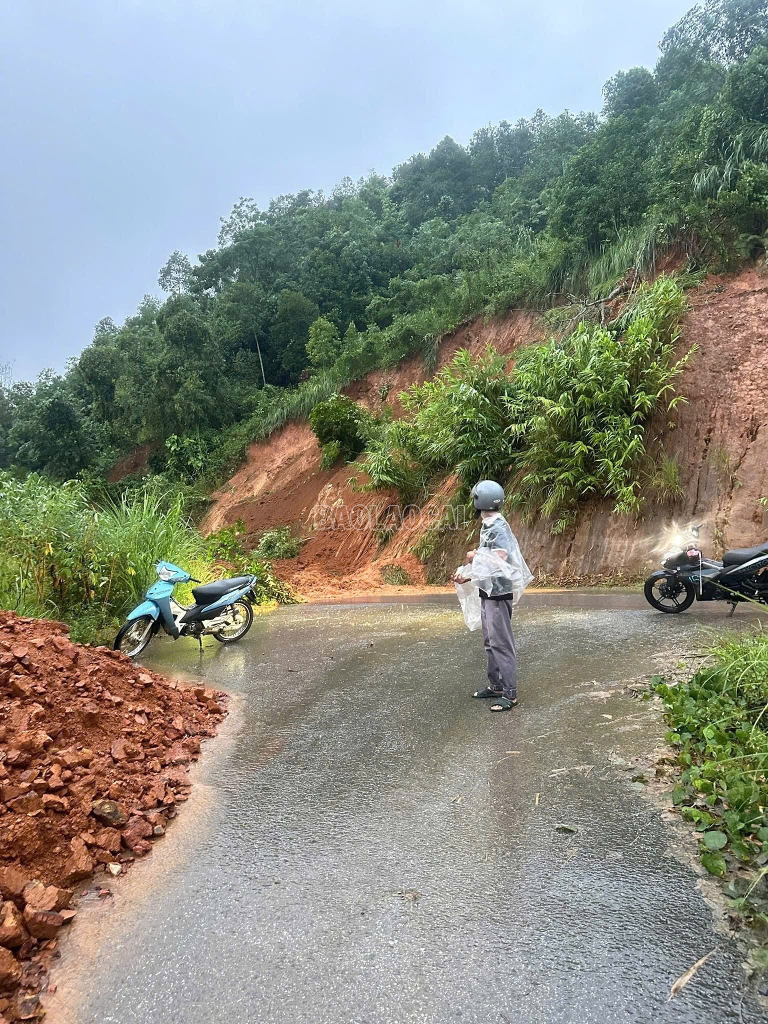
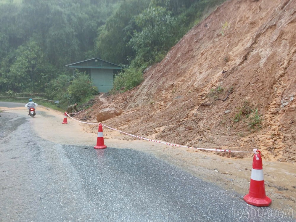
Due to the impact of prolonged heavy rain, at noon on September 29, on Provincial Road 158, from Mo Phu Chai village to Ngai Tro village, Y Ty commune, a landslide occurred with a large volume of soil and rock, causing traffic congestion.


Immediately after the landslide, local authorities and relevant units stretched ropes and put up warning signs, not allowing people to move around to ensure safety.
It is known that Provincial Road 158, the section passing through Y Ty commune is under construction and upgrading, so there are many landslides, especially during periods of prolonged heavy rain. People need to pay close attention and strictly follow the instructions of the authorities and local authorities to ensure safety.

Currently, construction units have mobilized human resources, vehicles, and machinery to handle the landslide. However, in Y Ty commune, it is still raining, there is a risk of further major landslides, so the repair and road clearance have not been carried out to ensure safety.
Source: https://baolaocai.vn/cap-nhat-tinh-hinh-mua-lu-tren-dia-ban-tinh-ngay-29-va-309-post883205.html
![[Photo] Students of Binh Minh Primary School enjoy the full moon festival, receiving the joys of childhood](https://vphoto.vietnam.vn/thumb/1200x675/vietnam/resource/IMAGE/2025/10/3/8cf8abef22fe4471be400a818912cb85)


![[Infographic] Notable numbers after 3 months of "reorganizing the country"](https://vphoto.vietnam.vn/thumb/1200x675/vietnam/resource/IMAGE/2025/10/4/ce8bb72c722348e09e942d04f0dd9729)


![[Photo] Prime Minister Pham Minh Chinh chairs meeting to deploy overcoming consequences of storm No. 10](https://vphoto.vietnam.vn/thumb/1200x675/vietnam/resource/IMAGE/2025/10/3/544f420dcc844463898fcbef46247d16)


Comment (0)