

At the regular press conference of the Ministry of Agriculture and Environment on October 6, Mr. Hoang Duc Cuong, Deputy Director of the Department of Hydrometeorology, said that in the first 9 months of 2025, natural disasters in Vietnam were more complicated, unusual and tended to be more extreme than the average of many years.
Natural disasters are concentrated with high danger levels in the Northern, North Central, and Central Central regions, showing a clear trend of seasonal shifts in natural disasters (extreme rains not only occur in the rainy season but also in the dry season), with severe intensity and wide range of impact.
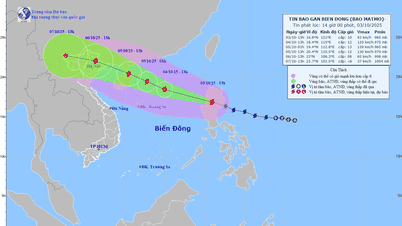
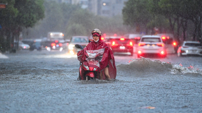
Mr. Cuong informed that the 2025 storm season recorded rare extreme numbers in terms of intensity, frequency and scope of influence. In the first 9 months of 2025 alone, the East Sea had 14 storms and tropical depressions (10 storms, 4 tropical depressions), much higher than the average of many years. Of these, 6 storms (numbers 1, 3, 5, 6, 9, 10) directly and indirectly affected our country, creating a series of natural disasters, with almost no break long enough to overcome the consequences.
As early as June, storm No. 1 (Wutip storm), the first storm to appear in the East Sea in more than 40 years. Although storm No. 1 did not make landfall, its circulation caused record rainfall of 250 - 550 mm from South Ha Tinh to Da Nang , in many places exceeding 800 mm, leading to historic floods on the rivers of the Central region.
Just over a month later, storms No. 3 and No. 5 made landfall consecutively, causing winds of level 10-11, gusts of level 12, rain of 200-400 mm, in some places over 500 mm, causing floods exceeding level 3 on the Ca River, Ma River, Hoang Long River, Thao River systems...
Super typhoon No. 9 (super typhoon Ragasa) appeared in the East Sea in late September. For the first time in the history of forecasting, Vietnam determined that the storm's wind level reached level 17, gusting above level 17, the final level of the Bo-pho typhoon wind scale. This is the strongest super typhoon ever recorded in the East Sea. Although it weakened before reaching the shore, it showed the real risk of super typhoons in the context of climate change.
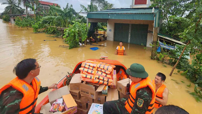
In particular, right after storm No. 9, storm No. 10 (storm Bualoi) made landfall directly in Ha Tinh and Northern Quang Tri with wind speeds of level 10-12, gusts of level 14, and widespread rain of 300-600 mm, causing widespread flooding, landslides, and flash floods from the North to the Central region. This is a storm with many unusual and extreme features.
There have been 14 widespread heavy rains across the country, including two unseasonal rains from the night of May 22 to 24 and from the night of June 10 to 13 in the Northern and Central Central regions.
Within just one month, storm No. 5 and storm No. 10 caused two serious and very serious natural disasters, fierce and occurring almost simultaneously.
The Deputy Director of the Department of Hydrometeorology forecasts that the trend of severe weather will continue to occur. From now until the end of 2025, the ENSO phenomenon is likely to remain in a neutral state and lean towards the cold phase, but not yet reaching a La Nina cycle.
From October to December 2025, storms and tropical depressions operating in the East Sea and affecting our country are likely to be higher than the average of many years (average of many years in the East Sea: 4.5 storms, making landfall: 1.9 storms). "This year is higher, at least 4-5 storms in the East Sea, of which 2-3 storms will affect our country," Mr. Cuong commented.
Along with that, from around October 2025, cold air tends to increase in intensity and frequency. Cold air is likely to be active from November to December 2025, severe cold in the North is likely to appear from the second half of December (equivalent to the average of many years).
Source: https://baohaiphong.vn/du-bao-con-it-nhat-4-den-5-con-bao-tren-bien-dong-522775.html


Comment (0)