
Sir, what is the current development of storm Matmo and what are the international and Vietnamese forecasts for this storm?
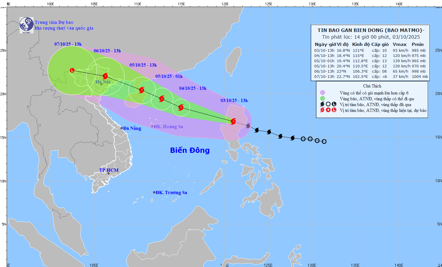
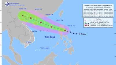
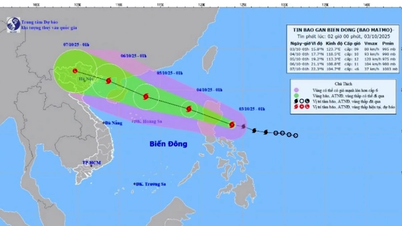
On the morning of October 2, the tropical depression in the sea east of the Philippines intensified into a storm - the 21st storm in the Northwest Pacific region and has the international name Matmo (the storm name was given by the United States. Matmo in Chamorro means heavy rain). By noon on October 3, storm Matmo was in the eastern coast of Luzon Island (Philippines).
The forecasts of the International Storm Forecast Centers are relatively consistent, predicting that on the afternoon of October 3, storm Matmo will move into the East Sea, and on the afternoon and night of October 5, it will pass through the area between Hainan Island and Leizhou Peninsula (China) to enter the northern part of the Gulf of Tonkin. The storm's intensity when in the eastern part of Leizhou Peninsula (China) is level 12-13, when entering the Gulf of Tonkin, the storm's intensity will decrease to level 10, then it is likely to move into the mainland of Quang Ninh province and gradually weaken.
According to the Vietnam Hydrometeorological Forecasting Agency, around the evening of October 3, storm Matmo will pass the northern area of Luzon Island (Philippines) into the East Sea and become the 11th storm in the East Sea in 2025. It is forecasted that after moving into the East Sea, it will encounter relatively favorable sea surface temperature conditions (about 29 degrees Celsius), and wind shear in the northern area of the East Sea (where the center of storm Matmo moves into) is small, favorable for the development of the storm. Meanwhile, the subtropical high pressure, the shape that determines the speed of movement in the direction of storm Matmo, will strongly encroach to the West, causing storm Matmo to tend to strengthen and move quickly (average from 25-30 km/h). The maximum intensity of the storm can reach level 12-13, gusting to level 14-15 when in the east of Leizhou Peninsula (China).
When moving into the sea area of Guangdong province (China), what will the development of storm No. 11 be like, sir?
From the time the storm moves into the sea area of Guangdong province (China), the subtropical high pressure tongue tends to weaken, at this time there will be 2 scenarios for the movement of storm No. 11.
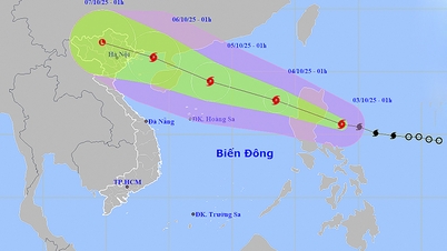
Scenario 1 (with a probability of about 70 - 75%) corresponds to the trend of the subtropical high pressure tongue weakening rapidly and retreating to the East, storm No. 11 will move more to the North, moving more over land (quite similar to the path of storm No. 9), so when it reaches the northern area of Quang Ninh province, it will weaken by 2-4 levels compared to the time when the storm is strongest. With this scenario, in the Gulf of Tonkin, strong winds will be level 9-10, in the mainland of Quang Ninh - Hai Phong, strong winds will be level 8-9, and there will be heavy rain in the North (focusing on the midlands and mountainous areas).
Scenario 2 is more extreme (with a probability of about 25 - 30%): when the subtropical high pressure weakens insignificantly, causing the storm to move mainly over the sea, so it weakens less than scenario 1. Therefore, the storm intensity when entering the Quang Ninh area will be stronger than scenario 1, possibly causing strong winds of level 9-10 (gusts of level 12-14), the impact will extend further south (Quang Ninh - Ninh Binh), the rain will also be heavier, the strong wind area will also be deeper inland.
The storm's movement is likely to change as it moves into the East Sea (then the scenarios will be clearer), so it is necessary to continuously update information about storm Matmo (storm No. 11). The Department of Hydrometeorology is issuing 4 bulletins/day about storm Matmo. From the afternoon of October 3, when storm Matmo enters the East Sea, the Department will issue 8 bulletins/day.
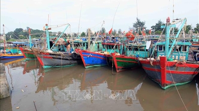
Regarding the heavy rain situation due to the impact of storm Matmo (Storm No. 11), it is forecasted that from the night of October 5 to the end of the night of October 7, the Northern region and Thanh Hoa will have heavy to very heavy rain with common rainfall of 100-200mm, locally over 300mm; in the mountainous and midland areas of the North, common rainfall will be from 150-250mm, locally over 400mm.
From October 6 to 9, in the North, Thanh Hoa and Nghe An, there was a flood, the flood peak on rivers was from above alert level 2 to above alert level 3.
Thank you very much!
Source: https://baotintuc.vn/van-de-quan-tam/chieu-toi-310-bao-matmo-vao-bien-dong-du-bao-se-gay-mua-lon-tai-bac-bo-va-thanh-hoa-20251003141338553.htm

![[Photo] Students of Binh Minh Primary School enjoy the full moon festival, receiving the joys of childhood](https://vphoto.vietnam.vn/thumb/1200x675/vietnam/resource/IMAGE/2025/10/3/8cf8abef22fe4471be400a818912cb85)


![[Photo] Prime Minister Pham Minh Chinh chairs meeting to deploy overcoming consequences of storm No. 10](https://vphoto.vietnam.vn/thumb/1200x675/vietnam/resource/IMAGE/2025/10/3/544f420dcc844463898fcbef46247d16)


Comment (0)