
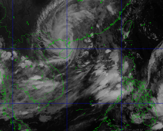
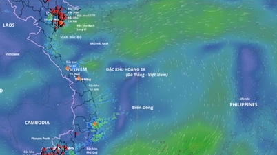
According to Mr. Hoang Phuc Lam, Deputy Director of the National Center for Hydro-Meteorological Forecasting, around tomorrow morning (September 25), the storm center will move into the northern part of the Gulf of Tonkin, the storm intensity is expected to be around level 10-11, gusting to level 13-14.
Heavy rain in Hanoi and neighboring provinces
Tonight, Quang Ninh, Lang Son and Hai Phong will start to have rain. Hanoi is forecast to be cloudy with moderate to heavy rain and thunderstorms, some places will have very heavy rain. The north to northwest wind will be level 2-3, increasing to level 5 in the early morning. The lowest temperature will be 23-25°C, the highest will drop sharply to 27-29°C. From noon on September 25, rainfall will increase, with a total forecast of 100-250 mm, some places exceeding 400 mm.
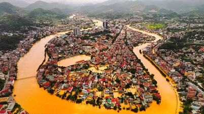
River flood warning and risk of inundation
From September 24-27, rivers in the North, Thanh Hoa, and Nghe An may experience floods, with a rise of 4-7 m in the upstream and 2-4 m in the downstream. Some rivers such as Thao, Lo, the upstream of Thai Binh , Hoang Long, Buoi, and Ma may reach alert level 2-3. There is a high risk of flooding in low-lying areas, flash floods in small streams, and landslides in mountainous areas.
The eastern slopes of the Hoang Lien Son range in Lao Cai and Yen Bai are likely to receive very heavy rain, which can easily cause flash floods and landslides. In Hanoi, people need to be on guard against flooding in the inner city and proactively plan safe travel during heavy rain days.
Source: https://baonghean.vn/ha-noi-co-mua-to-den-rat-to-vao-trua-mai-25-9-do-sieu-bao-ragasa-10307053.html
![[Photo] Discover unique experiences at the first World Cultural Festival](https://vphoto.vietnam.vn/thumb/1200x675/vietnam/resource/IMAGE/2025/10/11/1760198064937_le-hoi-van-hoa-4199-3623-jpg.webp)


![[Photo] Opening of the World Cultural Festival in Hanoi](https://vphoto.vietnam.vn/thumb/1200x675/vietnam/resource/IMAGE/2025/10/10/1760113426728_ndo_br_lehoi-khaimac-jpg.webp)

![[Photo] General Secretary attends the parade to celebrate the 80th anniversary of the founding of the Korean Workers' Party](https://vphoto.vietnam.vn/thumb/1200x675/vietnam/resource/IMAGE/2025/10/11/1760150039564_vna-potal-tong-bi-thu-du-le-duyet-binh-ky-niem-80-nam-thanh-lap-dang-lao-dong-trieu-tien-8331994-jpg.webp)


![[Photo] Ho Chi Minh City is brilliant with flags and flowers on the eve of the 1st Party Congress, term 2025-2030](https://vphoto.vietnam.vn/thumb/1200x675/vietnam/resource/IMAGE/2025/10/10/1760102923219_ndo_br_thiet-ke-chua-co-ten-43-png.webp)


Comment (0)