
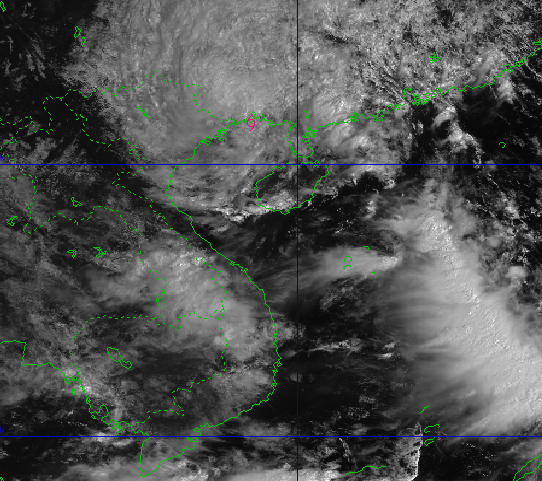
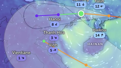
Location and direction of storm Ragasa
According to the National Center for Hydro-Meteorological Forecasting, at 10:00 a.m. on September 25, the center of storm Ragasa was located at about 21.5 degrees North latitude; 108.4 degrees East longitude, about 40km east of Mong Cai ( Quang Ninh ). The strongest wind near the center of the storm reached level 7 (50 - 61km/h), gusting to level 9. In the next 3 hours, the storm will move westward at a speed of about 15-20km/h.
Impact of Storm Ragasa on the mainland
Due to the impact of storm Ragasa, the northern Gulf of Tonkin experienced storms. Other areas such as Hoang Sa, Truong Sa, the southern Gulf of Tonkin and along the coast from southern Quang Tri to Ca Mau all experienced scattered showers and thunderstorms.
During thunderstorms, there is a risk of tornadoes, strong gusts of wind of level 6-7 and waves over 2m high, posing a danger to ships operating offshore.
Warning of natural disaster risks in the next 24 hours
During the day and night of September 25, the northern area of Bac Bo Gulf including Bach Long Vy, Van Don, Co To, Cat Hai and Hon Dau will have strong winds of level 6-7, gusting to level 8-9. Waves 2-3m high will cause rough seas in this area, however the wind is forecast to gradually decrease at night.
In the sea area from Khanh Hoa to Can Tho and the central and southern East Sea (including Truong Sa), southwest wind remains at level 6, gusting to level 7-8, with waves 2-4m high.
In the North East Sea, the Southeast to East wind sometimes reaches level 6, gusting to level 7-8, causing rough seas with waves 2-4m high.
On September 26, the sea area from Khanh Hoa to Ho Chi Minh City and the South East Sea continues to have southwest winds of level 6, gusting to level 7-8, with waves 2-4m high.
In particular, from noon to afternoon of the same day, the Northeast and East Sea regions will gradually increase in strength to level 6-7, then increase to level 8-9, near the center of storm Ragasa it can reach level 10-12, gusting to level 15, waves 5-7m high, and rough seas.
The risk of natural disasters at sea is assessed at level 3 in the northern Gulf of Tonkin and level 2 in other areas. The impact of heavy rain, tornadoes, lightning and hail is forecast at level 1.
Heavy rain forecast for the next 48 hours
From the morning of September 25 to the night of September 26, the Northern region, Thanh Hoa and Nghe An will have heavy to very heavy rain with rainfall ranging from 100-200mm, some places may exceed 300mm. Warning of extremely heavy rain over 100mm/3 hours, potential risk of flash floods and inundation.
In addition, in the Central Highlands and the South, on the evening of September 25, there will be scattered showers and thunderstorms, with rainfall ranging from 15-30mm, with some places exceeding 70mm. Heavy rain accompanied by the possibility of tornadoes, lightning, hail and strong gusts of wind.
Prolonged heavy rain can easily cause flooding in urban areas, industrial zones and low-lying areas. In small rivers and streams, the risk of flash floods and landslides on steep slopes is very high.
From September 27, heavy rains in the North, Thanh Hoa and Nghe An are forecast to gradually decrease, but the impacts of storm Ragasa still need to be closely monitored to limit damage.
Source: https://baonghean.vn/tin-bao-so-9-ragasa-moi-nhat-luc-10h00-hom-nay-25-9-2025-cach-quang-ninh-40km-10307070.html

![[Photo] Prime Minister Pham Minh Chinh chairs a meeting of the Government Standing Committee on overcoming the consequences of natural disasters after storm No. 11](https://vphoto.vietnam.vn/thumb/1200x675/vietnam/resource/IMAGE/2025/10/09/1759997894015_dsc-0591-jpg.webp)

![[Photo] Prime Minister Pham Minh Chinh chairs the Conference to deploy the National Target Program on Drug Prevention and Control until 2030](https://vphoto.vietnam.vn/thumb/1200x675/vietnam/resource/IMAGE/2025/10/09/1759990393779_dsc-0495-jpg.webp)


Comment (0)