
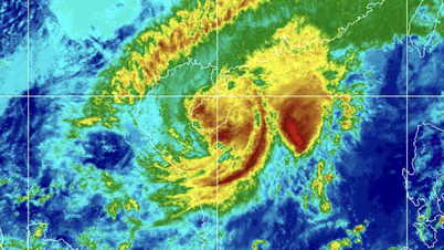
According to the National Center for Hydro-Meteorological Forecasting, on the morning of October 22, cold air affected some places in the Central Central region. At Bach Long Vi station, there were strong northeast winds of level 7, gusting to level 9; at Con Co station, there were strong northeast winds of level 6, gusting to level 7.
It is forecasted that in the afternoon and night of October 22, cold air will continue to affect other places in the Central Central region. Inland, strong northeast winds will be level 3, coastal areas level 4, and in some places level 5; coastal provinces from Quang Tri to Da Nang City, due to the influence of storm No. 12's circulation combined with strong cold air, from the afternoon of October 22, winds will gradually increase to level 6, sometimes level 7, gusting to level 8-9.
In the North and Thanh Hoa , the morning and night are cold, in the mountainous areas it is cold. The lowest temperature in the Delta and Thanh Hoa is 19 - 22 degrees Celsius; in the midlands and mountainous areas the lowest is 17 - 19 degrees Celsius; in the high mountainous areas it is below 16 degrees Celsius.
Hanoi area sunny day, no rain at night. Cold morning and night. The lowest temperature in this cold air mass is commonly 19 - 22 degrees Celsius.
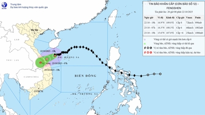
Mr. Mai Van Khiem, Director of the National Center for Hydro-Meteorological Forecasting, Department of Hydro-Meteorological Forecasting, said that due to the influence of storm No. 12's circulation combined with the strong strengthening of cold air, from the afternoon of October 22, the coastal mainland of provinces from Quang Tri to Da Nang city will have winds gradually increasing to level 6, sometimes level 7, gusting to level 8-9.
The representative of the meteorological agency especially emphasized that due to the influence of storm circulation and cold air combined with easterly wind disturbances and terrain effects, the Central region is facing a very heavy rain.
From noon on October 22 to October 27, the area from Ha Tinh to Quang Ngai will have widespread heavy rain. The total rainfall in the area from Ha Tinh to northern Quang Tri and Quang Ngai will be about 200 - 400 mm, locally over 500 mm.
Heavy rains will be concentrated from the afternoon of October 22 to the end of October 23. In the south of Quang Tri, Hue, and Da Nang, rainfall will be 500-700 mm, with some places experiencing over 900 mm. The Central region is likely to experience a large-scale flood, especially in the river basin from the south of Quang Tri to Quang Ngai, with flood levels possibly exceeding alert level 3 - equivalent to or even higher than the major floods of November 2017.
"The flood level may not be equal to 2020, but the complexity until the end of October and early November requires continued monitoring and updating," Mr. Khiem analyzed.
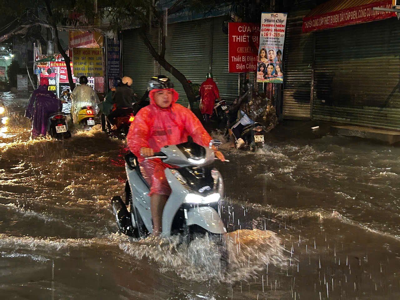
The director of the meteorological agency further warned of the possibility of heavy rain with rainfall of 200 - 300 mm/3 hours, related to the risk of flash floods and landslides in mountainous areas, flooding in low-lying areas and urban areas. The National Center for Hydro-Meteorological Forecasting recommends taking precautions against the risk of thunderstorms, tornadoes, and strong gusts of wind in the storm's circulation area, both before and during the storm's landfall.
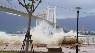
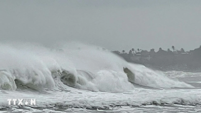
Due to the influence of cold air combined with the circulation of storm No. 12, the North East Sea area (including Hoang Sa special zone) has strong northeast winds of level 7-8; especially the western sea area near the storm's eye has strong winds of level 9-10, gusts of level 12, waves 3-5m high, near the storm's eye 5-7m high. The sea is very rough. The Gulf of Tonkin has strong northeast winds of level 7, gusts of level 9, rough seas, waves 2-4m high.
The sea area from Quang Tri to Quang Ngai (including Con Co special zone, Ly Son special zone and Cu Lao Cham island) has strong winds of level 6 - 7, the area near the storm's eye has winds of level 8, gusts of level 10, waves 3 - 5m high. Rough seas.
Experts warn that tornadoes, lightning, hail, and strong winds can cause damage to agriculture, trees, houses, and traffic and infrastructure. Heavy rains can cause flooding in low-lying areas; flash floods on small rivers and streams; and landslides on steep slopes. Heavy rains in a short period of time can cause flooding in urban and industrial areas. Strong winds and large waves can affect shipping and other activities at sea.
In particular, cold weather at night and morning can affect health, especially for the elderly and children.
Source: https://baotintuc.vn/xa-hoi/khong-khi-lanh-ket-hop-bao-so-12-se-gay-mua-to-tu-chieu-2210-20251022103128634.htm

![[Photo] Da Nang: Shock forces protect people's lives and property from natural disasters](https://vphoto.vietnam.vn/thumb/1200x675/vietnam/resource/IMAGE/2025/10/22/1761145662726_ndo_tr_z7144555003331-7912dd3d47479764c3df11043a705f22-3095-jpg.webp)

![[Photo] Award Ceremony of the Political Contest on Protecting the Party's Ideological Foundation](https://vphoto.vietnam.vn/thumb/1200x675/vietnam/resource/IMAGE/2025/10/22/1761151665557_giaia-jpg.webp)

![[Photo] Prime Minister Pham Minh Chinh chairs meeting on nuclear power plant construction](https://vphoto.vietnam.vn/thumb/1200x675/vietnam/resource/IMAGE/2025/10/22/1761137852450_dsc-9299-jpg.webp)


Comment (0)