
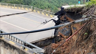
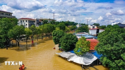
According to the National Center for Hydro-Meteorological Forecasting, many localities in the North are still at risk of flash floods and landslides due to continued rain, although rainfall has decreased sharply.
Particularly large floods on Cau River and Thuong River ( Bac Ninh ) continue to rise and are likely to peak early in the morning of October 9.
In the past 24 hours (from 4:00 p.m. on October 7 to 4:00 p.m. on October 8), the provinces of Lao Cai, Tuyen Quang, Cao Bang , Thai Nguyen and Bac Ninh had moderate rain, heavy rain, and in some places very heavy rain.
It is forecasted that the above provinces will continue to have rain with accumulated rainfall of 5-10mm, in some places over 30mm. There is a risk of flash floods on small rivers and streams, landslides on steep slopes in many communes/wards of the provinces: Lao Cai, Tuyen Quang, Thai Nguyen, Cao Bang, Bac Ninh. Warning level of natural disaster risk due to flash floods, landslides, land subsidence due to rain, floods or water flow: Level 1; Thai Nguyen is level 2.
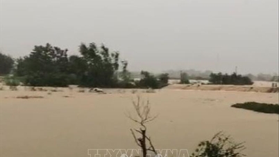
Flash floods and landslides can have very negative impacts on the environment, threaten people's lives; cause local traffic congestion, affect the movement of vehicles; destroy civil and economic works, causing damage to production and socio-economic activities.
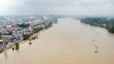
Currently, floods on Cau River and Thuong River (Bac Ninh) continue to rise. Floods on Trung River (Lang Son) are at their peak. Water levels at 1:00 p.m. on October 8 on the rivers are as follows: On Cau River at Gia Bay station 29.49m, 0.68m above the historical level in 2024 (28.81m), at Dap Cau station 6.77m, 0.47m above alert level 3. On Thuong River at Cau Son station 17.97m, 1.97m above alert level 3, at Phu Lang Thuong station 7.41m, 1.11m above alert level 3. On Trung River at Huu Lung station 24.31m, 1.77m above the historical level in 1986 (22.54m).
It is forecasted that in the next 6 hours, the flood on the Thuong River at Cau Son is likely to peak and be about 0.88m above the historical flood level. The flood on the Cau River at Gia Bay station continues to decrease and is about 1.5m above alert level 3; at Dap Cau station it continues to rise and is about 0.69m below the historical flood level of 1971 (7.84m). The flood on the Thuong River at Phu Lang Thuong station continues to rise and is about 0.13m above the historical flood level of 1986 (7.52m).
In the next 6-24 hours, floods on Cau and Thuong rivers are likely to peak in the early morning of October 9; flood peak at Dap Cau station is about 0.9m above alert level 3, flood peak at Phu Lang Thuong station is about 0.18m above historical flood level.
Warning: From this afternoon (October 8) to October 9, floods on some small rivers in Lang Son and Cao Bang will remain above alert level 3. Floods on Luc Nam River (Bac Ninh) at Luc Nam station will change slowly at alert level 1- alert level 2. Floods on Thai Binh River (Hai Phong) at Pha Lai station will gradually rise and above alert level 2.
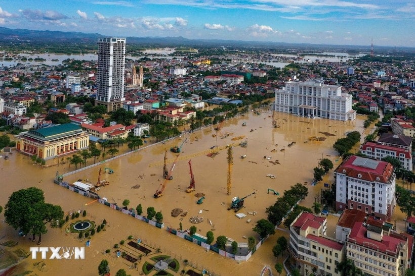
Widespread flooding in Thai Nguyen province (maintaining for the next 2-3 days), Bac Ninh, Lang Son, Cao Bang and risk of flooding in low-lying areas along rivers, urban areas in the Northern region; risk of landslides on river banks, river dykes, risk of flash floods on rivers and streams and landslides on slopes in mountainous areas of the Northern region. Flood risk warning level: Level 3.
River floods inundate low-lying areas along the river, affecting activities such as waterway transport, aquaculture, agricultural production, people's lives and socio-economic activities.
According to VNASource: https://baohaiphong.vn/lu-dac-biet-lon-tren-song-cau-song-thuong-va-kha-nang-dat-dinh-vao-sang-som-9-10-522980.html


![[Photo] Prime Minister Pham Minh Chinh inspects and directs the work of overcoming the consequences of floods after the storm in Thai Nguyen](https://vphoto.vietnam.vn/thumb/1200x675/vietnam/resource/IMAGE/2025/10/08/1759930075451_dsc-9441-jpg.webp)

![[Photo] Prime Minister Pham Minh Chinh attends the World Congress of the International Federation of Freight Forwarders and Transport Associations - FIATA](https://vphoto.vietnam.vn/thumb/1200x675/vietnam/resource/IMAGE/2025/10/08/1759936077106_dsc-0434-jpg.webp)


![[Photo] Closing of the 13th Conference of the 13th Party Central Committee](https://vphoto.vietnam.vn/thumb/1200x675/vietnam/resource/IMAGE/2025/10/08/1759893763535_ndo_br_a3-bnd-2504-jpg.webp)


Comment (0)