
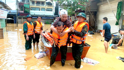
Many northern provinces are being flooded extensively, from Hanoi to Thai Nguyen, Lang Son, Cao Bang, Bac Ninh… Many areas are being isolated and surrounded by floods, many people are having to stand on rooftops waiting for rescue.

What is the reason for such widespread and deep flooding in many northern provinces? Mr. Le Ngoc Quyen, Deputy Director of the Northern Hydrometeorological Station, Department of Hydrometeorology, Ministry of Agriculture , has given some explanations on this issue.
What is the cause of the recent rain and flood in Cao Bang, Thai Nguyen, and Lang Son, sir?
+ Mr. Le Ngoc Quyen : Early morning on October 6, after entering the mainland of the Fangcheng area of Guangxi province (China), it continued to move in the West Northwest direction and weakened into a low pressure area. By the night of October 6, this low pressure area was located in the mountainous areas of the Northern provinces.

From the night of October 6 to the afternoon of October 7, due to the strong Southeast wind zone from the ground up to over 5,000m combined with the Southwest wind zone from the Bay of Bengal moving up to form a convergence zone of meridional winds in the mountainous and midland areas of the Viet Bac region, causing heavy to very heavy rain in the provinces of Cao Bang, Thai Nguyen, and Lang Son.
Rainfall in 36 hours (from 7am on October 6 to 7pm on October 7) in Thai Nguyen is generally 200-400mm, some places are larger such as in Dong Hy 596mm, Nam Hoa 554mm, Phan Dinh Phung Ward 514mm...
In Cao Bang, the rainfall is generally 100-200mm, some places are larger such as: Xuan Truong 293mm, Nguyen Binh 273mm, Minh Tam 266mm... In Lang Son, the rainfall is generally 100-200mm, some places are larger such as Yen Binh 334mm, Tan Tri 290mm, Thien Tan 279mm...
With heavy rainfall, the total rainfall in 36 hours exceeds the average total rainfall value of many years in the whole month of October, occurring in a short period of time combined with terrain with a steep slope from North to South, narrow riverbed and strong winding, reducing the drainage speed when heavy rain occurs.
As a result, when the water above rushed down quickly, the water below could not drain in time, causing serious flooding and heavy rain in the provinces of Cao Bang, Thai Nguyen, and Lang Son in recent days.

. So what is the forecast for rain in the northern region in the next hours? Will there be any more heavy rain?
+ According to our assessment, in the coming hours, the weather in the Northern provinces will continue to improve, with sunshine, showers and thunderstorms only occurring in a few places and there is no longer a possibility of widespread heavy rain.
What is the current flood situation of rivers in the Northern region, sir?
+ Over the past 24 hours, the water levels of Gam, Giang, Cau, Thuong, Trung, Bac Giang rivers in Tuyen Quang, Cao Bang, Thai Nguyen, Lang Son, Bac Ninh provinces have risen, with peak flood levels at many stations exceeding flood level 3.
In particular, the peak flood level at Gia Bay station (Cau river) is 29.90m, 2.90m above BĐ3, 1.09m above the historical flood level; Huu Lung station (Trung river) is 24.31m, 5.31m above BĐ3, 1.77m above the historical flood level; Cau Son station (Thuong river) is 17.97m, 1.97m above BĐ3, 0.36m above the historical level.
Currently, the water levels of the rivers are falling. In particular, the rivers in Bac Ninh are rising, and the Trung River (Lang Son) is rising slowly.
. What is the forecast for the Northern rivers in the next hours, sir?
+ Currently, the water level of rivers continues to decrease. Particularly, rivers in Bac Ninh are rising and are likely to peak tonight (October 8) to tomorrow morning (October 9). The flood peak on Cau River exceeds BĐ3 by about 1.0m, Thuong River exceeds alert level 3 by 1.5 - 2.0m and exceeds history by 0.3 - 0.5m. Trung River (Lang Son) continues to rise slowly and is likely to peak this evening.

Which areas continue to be affected by flooding? How long will the flooding last?
+ In Thai Nguyen, widespread flooding lasted for 3-4 days, and in some places longer, in many areas of communes and wards such as: Phan Dinh Phung, Gia Sang, Tich Luong, Linh Son, Quan Trieu, Phu Luong, Quang Son, Dong Hy, An Khanh, Yen Trach, La Hien, Nghinh Tuong, Nam Hoa, Trung Hoi.
There are also communes and wards such as: Van Han, Phu Dinh, Trung Hoi, Dong Hy, Dai Phuc, Than Sa, Binh Thanh, Trai Cau, Lam Vy, Dan Tien, Van Xuan, Pho Yen, Diem Thuy, Phu Binh, Kha Son, Phu Binh, Dai Tu, Phu Lac; Nam Cuong, Ba Be, Cho Ra, Hiep Luc, Na Ri, Van Lang, Cuong Loi, Con Minh, Xuan Duong, Bac Kan Ward, Yen Binh, Cho Moi....
In Bac Ninh, widespread flooding lasted for 2-3 days, and in some places longer, in many areas of communes and wards such as: Tam Tien, Xuan Luong, Yen The, My Thai, Dong Ky, Lang Giang, Kep Commune, Tien Luc, Tan Yen, Tien Phong Ward, Bac Giang Ward, Yen Dung, Viet Yen Ward, Hop Thinh, Xuan Cam, Tam Giang, Yen Trung, Tam Da, Nenh Ward, Yen Dung, Canh Thuy...
In Cao Bang, widespread flooding lasted for 1-2 days, and in some places longer, in many areas of riverside residential areas in Hoa An commune, Thuc Phan ward, Nung Chi Cao, Tan Giang, Phuc Hoa commune...
Lang Son, widespread flooding for 2-3 days, in some places longer in many areas of communes and wards such as: Yen Binh, Van Nham, Huu Lung, Tuan Son, Cai Kinh...
Thank you!
Source: https://baolaocai.vn/nguyen-nhan-khien-nhieu-tinh-mien-bac-ngap-lut-dien-rong-post884019.html

![[Photo] Prime Minister Pham Minh Chinh attends the World Congress of the International Federation of Freight Forwarders and Transport Associations - FIATA](https://vphoto.vietnam.vn/thumb/1200x675/vietnam/resource/IMAGE/2025/10/08/1759936077106_dsc-0434-jpg.webp)
![[Photo] Prime Minister Pham Minh Chinh inspects and directs the work of overcoming the consequences of floods after the storm in Thai Nguyen](https://vphoto.vietnam.vn/thumb/1200x675/vietnam/resource/IMAGE/2025/10/08/1759930075451_dsc-9441-jpg.webp)


![[Photo] Closing of the 13th Conference of the 13th Party Central Committee](https://vphoto.vietnam.vn/thumb/1200x675/vietnam/resource/IMAGE/2025/10/08/1759893763535_ndo_br_a3-bnd-2504-jpg.webp)


Comment (0)