
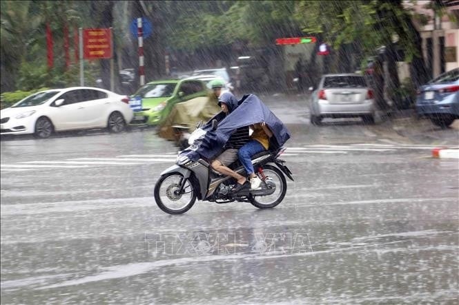
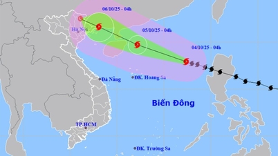
It is forecasted that in the next 24 to 72 hours, storm No. 11 will move in the West-Northwest direction, at a speed of about 25km/h and is likely to strengthen. At 7:00 p.m. on October 4, storm No. 11 was located at 19.1 degrees North latitude - 114.0 degrees East longitude, in the North East Sea, about 350km East-Southeast of Leizhou Peninsula (China), with a strength of level 12, gusting to level 15. Due to the influence of the storm, the sea area east of the North East Sea will have strong winds of level 8-9, the area near the center of the storm will have strong winds of level 10-11, gusting to level 14, waves 4-6m high, and rough seas.
Due to the influence of the storm, the eastern sea area of the North East Sea has strong winds of level 8-9, the area near the storm's eye has strong winds of level 10-11, gusts of level 14, waves 4.0-6.0m high, and very rough seas.
From the morning of October 4, the North East Sea area has strong winds of level 8-10, the area near the storm's eye has winds of level 11-13, gusts of level 16, waves 4.0-6.0m high, the area near the storm's eye has waves of 6.0-8.0m, and the sea is very rough.
From the afternoon of October 5, the sea area east of the Northern Gulf of Tonkin (including Bach Long Vi special zone) has winds gradually increasing to level 6-7, then increasing to level 8-9. From the evening of October 5, the northern Gulf of Tonkin area (including Bach Long Vi special zone, Van Don, Co To, Cat Hai and Hon Dau island) has winds gradually increasing to level 8-9, waves 2.0-4.0m high, the area near the storm center has winds of level 10-11, gusts of level 14, waves 3.0-5.0m high, and rough seas.
Vessels operating in the above mentioned danger zones are susceptible to storms, whirlwinds, strong winds and large waves.
Forecast weather day and night 4-10 as follows:
Northwest: Cloudy, sunny day; light wind; temperature 22-33 degrees Celsius. Northeast: Cloudy, sunny day; Southeast wind level 2-3; temperature 23-34 degrees Celsius.
Hanoi area: No rain at night, sunny during the day; Southeast wind level 2-3; temperature 24-34 degrees Celsius.
Provinces from Thanh Hoa to Hue: Cloudy, sunny day; light wind; temperature 24-33 degrees Celsius.
South Central Coast: Cloudy, sunny during the day; from the evening there will be scattered showers and thunderstorms, locally heavy rain; thunderstorms may have tornadoes, lightning and strong gusts of wind; temperature 24-33 degrees Celsius.
Central Highlands: Cloudy, scattered showers and thunderstorms; thunderstorms may cause tornadoes, lightning and strong gusts of wind; temperature 20-32 degrees Celsius.
Southern region: Cloudy, scattered showers and thunderstorms; thunderstorms may cause tornadoes, lightning and strong gusts of wind; temperature 23-33 degrees Celsius.
Ho Chi Minh City: There will be showers and thunderstorms in some places; in the late afternoon and evening there will be scattered showers and thunderstorms, locally heavy rain in some places; light wind; in thunderstorms there is a possibility of tornadoes, lightning and strong gusts of wind; temperature 24-33 degrees Celsius.
Hoang Sa special economic zone (Da Nang): There is stormy rain; visibility is over 10km, reduced to 2-4km during storms; strong winds level 8-10, near the storm center level 11-13, gusting to level 16; very rough seas; waves 1.5-2.5m high.
Truong Sa special economic zone (Khanh Hoa): Scattered showers and thunderstorms; in thunderstorms there is a possibility of tornadoes and strong gusts of wind level 6-7; visibility is over 10km, decreasing to 4-10km in the rain; southwest wind level 4-5; waves are 0.5-1.5m high, in thunderstorms they are likely to be over 2m high.
Source: https://baolangson.vn/thoi-weather-hom-nay-4-10-bao-so-11-di-chuyen-nhu-the-nao-5060803.html
![[Infographic] Notable numbers after 3 months of "reorganizing the country"](https://vphoto.vietnam.vn/thumb/1200x675/vietnam/resource/IMAGE/2025/10/4/ce8bb72c722348e09e942d04f0dd9729)


![[Photo] General Secretary To Lam attends the 8th Congress of the Central Public Security Party Committee](https://vphoto.vietnam.vn/thumb/1200x675/vietnam/resource/IMAGE/2025/10/4/79fadf490f674dc483794f2d955f6045)


![[Photo] Students of Binh Minh Primary School enjoy the full moon festival, receiving the joys of childhood](https://vphoto.vietnam.vn/thumb/1200x675/vietnam/resource/IMAGE/2025/10/3/8cf8abef22fe4471be400a818912cb85)
![[Photo] Prime Minister Pham Minh Chinh chairs meeting to deploy overcoming consequences of storm No. 10](https://vphoto.vietnam.vn/thumb/1200x675/vietnam/resource/IMAGE/2025/10/3/544f420dcc844463898fcbef46247d16)


Comment (0)