
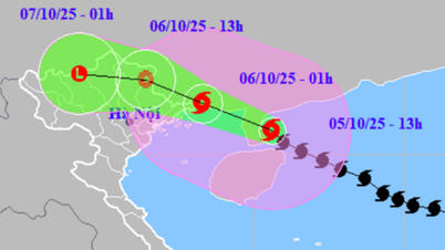
The strongest wind near the storm center is level 12 (118-133 km/h), gusting to level 15. The storm is moving rapidly in the West Northwest direction at a speed of 30 km/h, nearly double the average speed of the storm.
It is forecasted that in the next 24 hours, the storm will continue to move rapidly. By 4:00 p.m. on September 28, the storm center will be at about 17.5 degrees North latitude; 107.6 degrees East longitude, in the sea area from Nghe An to Quang Tri, with strong winds of level 12-13, gusts of level 16, and the possibility of further strengthening. By 4:00 a.m. on September 29, the storm will make landfall in the provinces from Thanh Hoa to Ha Tinh with strong winds of level 9-10, gusts of level 13, then gradually weaken as it moves further inland and by 4:00 p.m. on September 29, the storm center will be in the Upper Laos region.
Due to the impact of the storm, the western sea area of the North and Central East Sea, including the Hoang Sa sea area, has strong winds of level 8-9, the area near the storm center has level 10-13, gusts of level 16, waves 6-10 m high, and rough seas. The sea area from Thanh Hoa to Quang Ngai (including Hon Ngu, Con Co, Ly Son) has strong winds of level 6-7, later increasing to level 8-9, the area near the storm center has level 10-13, gusts of level 16, waves 5-7 m high, with the risk of causing serious damage to boats and coastal structures.
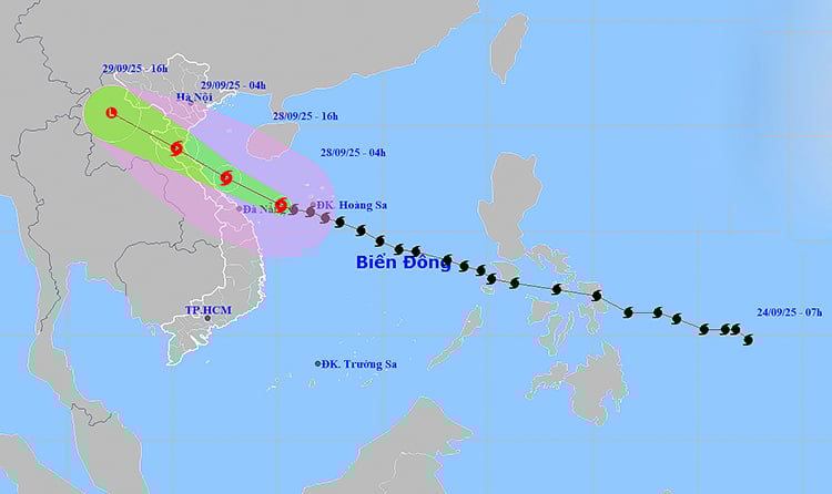
Location and path of storm number 10. Photo: thoitietvietnam
On land, the area from South Quang Tri to Da Nang will see winds gradually increase to level 6-7, gusting to level 8-9. From noon on September 28, the area from Thanh Hoa to North Quang Tri will see winds gradually increase to level 8-9, the area near the storm center will see winds of level 10-12, gusting to level 14. The coastal area from Quang Ninh to Ninh Binh will also be affected by strong winds of level 6-7, gusting to level 8-9.
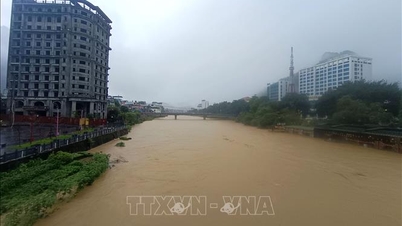
From September 28-30, the North and the area from Thanh Hoa to Quang Ngai will have heavy to very heavy rain, with rainfall ranging from 100-300 mm, in some places over 450 mm; in the Northern Delta, South Phu Tho and the area from Thanh Hoa to North Quang Tri, rainfall will range from 200-400 mm, locally over 600 mm.
Meteorological experts warn that storm No. 10 is an especially dangerous storm, moving quickly, with complex developments and a wide range of influence, and is forecast to cause a combined impact of many types of natural disasters such as strong winds, heavy rains, floods, flash floods, landslides and coastal flooding. People and local authorities need to urgently deploy preventive measures, ensure safety of life and property, and be ready to respond to emergency situations.
Weather forecast for regions across the country:
Hanoi capital is cloudy, afternoon and night there will be moderate rain, heavy rain and thunderstorms, locally very heavy rain. Northeast wind level 3. During thunderstorms there is a possibility of tornadoes, lightning and strong gusts of wind. Lowest temperature 23-25 degrees Celsius. Highest temperature 30-32 degrees Celsius.
The Northwestern provinces have cloudy days with scattered showers and thunderstorms; cloudy nights with moderate rain, heavy rain and thunderstorms, and locally very heavy rain. Light winds. During thunderstorms, there is a possibility of tornadoes, lightning, and strong gusts of wind. The lowest temperature is 22-25 degrees Celsius, in some places below 21 degrees Celsius. The highest temperature is 29-32 degrees Celsius, in some places above 32 degrees Celsius.
The Northeastern region is cloudy, with moderate rain in the afternoon and at night, heavy rain and scattered thunderstorms, locally very heavy rain; in the plains, there will be heavy to very heavy rain at night. Northeast wind level 3; in the coastal areas of Quang Ninh to Ninh Binh, the wind will gradually increase to level 6-7 from the afternoon, gusting to level 8-9. During thunderstorms, there is a possibility of tornadoes, lightning and strong gusts. The lowest temperature is 22-25 degrees Celsius, in mountainous areas, some places are below 21 degrees Celsius. The highest temperature is 28-31 degrees Celsius, some places are above 31 degrees Celsius.
Provinces from Thanh Hoa to Hue are cloudy, with heavy to very heavy rain and thunderstorms. Northwest wind level 3-4; from the afternoon, the area from Thanh Hoa to Northern Quang Tri gradually strengthens to level 6-7, then increases to level 8-9, the area near the storm center passes through level 10-12, gusting to level 14, from Southern Quang Tri to Hue City gradually strengthens to level 6-7, gusting to level 8-9. During thunderstorms, there is a possibility of tornadoes, lightning and strong gusts of wind. Lowest temperature 22-25 degrees Celsius. Highest temperature 26-29 degrees Celsius.
The South Central Coast region is cloudy, with heavy rain and thunderstorms in the North, with some places experiencing very heavy rain; scattered showers and thunderstorms in the South, with some places experiencing heavy rain. West to southwest winds at level 3-4, with some places experiencing level 5 in the North, gusting to level 6-7. During thunderstorms, there is a possibility of tornadoes, lightning, hail, and strong gusts of wind. The lowest temperature is 23-26 degrees Celsius. The highest temperature is 28-31 degrees Celsius, with some places experiencing over 31 degrees Celsius in the South.
Central Highlands cloudy with scattered showers and thunderstorms, locally heavy rain. Southwest wind level 2-3. Thunderstorms may cause tornadoes, lightning, hail and strong gusts. Lowest temperature 19-22 degrees Celsius. Highest temperature 25-28 degrees Celsius.
The South is cloudy with scattered showers and thunderstorms, with heavy rain in some places. Southwesterly winds level 2-3. Thunderstorms may include tornadoes, lightning, hail, and strong gusts of wind. Lowest temperature 23-26 degrees Celsius. Highest temperature 29-32 degrees Celsius.
Ho Chi Minh City is cloudy with scattered showers and thunderstorms, with heavy rain in some places. Southwest wind level 2-3. During thunderstorms, there is a possibility of tornadoes, lightning, hail and strong gusts of wind. Lowest temperature 24-26 degrees Celsius. Highest temperature 29-32 degrees Celsius.
Source: https://baotintuc.vn/xa-hoi/thoi-tiet-ngay-289-bao-so-10-ap-sat-dat-lien-voi-suc-gio-giat-cap-16-canh-bao-mua-cuc-lon-20250928060907003.htm

![[Photo] Prime Minister Pham Minh Chinh chairs the Government's online conference with localities](https://vphoto.vietnam.vn/thumb/1200x675/vietnam/resource/IMAGE/2025/10/5/264793cfb4404c63a701d235ff43e1bd)

![[Photo] Prime Minister Pham Minh Chinh launched a peak emulation campaign to achieve achievements in celebration of the 14th National Party Congress](https://vphoto.vietnam.vn/thumb/1200x675/vietnam/resource/IMAGE/2025/10/5/8869ec5cdbc740f58fbf2ae73f065076)


![[VIDEO] Summary of Petrovietnam's 50th Anniversary Ceremony](https://vphoto.vietnam.vn/thumb/402x226/vietnam/resource/IMAGE/2025/10/4/abe133bdb8114793a16d4fe3e5bd0f12)

![[VIDEO] GENERAL SECRETARY TO LAM AWARDS PETROVIETNAM 8 GOLDEN WORDS: "PIONEER - EXCELLENT - SUSTAINABLE - GLOBAL"](https://vphoto.vietnam.vn/thumb/402x226/vietnam/resource/IMAGE/2025/7/23/c2fdb48863e846cfa9fb8e6ea9cf44e7)


Comment (0)