
The National Center for Hydro-Meteorological Forecasting, Department of Hydro-Meteorology has just released information on the development of storm No. 10 Bualoi, expected to make landfall in our country tomorrow night (September 28).
The closer to shore, the stronger it gets.
Accordingly, storm Bualoi formed in the sea east of the Philippines, reaching level 12 before making landfall in the Philippines on September 26.
In the evening of the same day, storm Bualoi weakened to level 11, gusting to level 13, and entered the East Sea, becoming storm number 10 in 2025.
Currently, the storm is at level 11-12, moving west-northwest at a speed of about 35km/h. At 10am on September 27, the storm was about 370km east-southeast of Hoang Sa special zone.
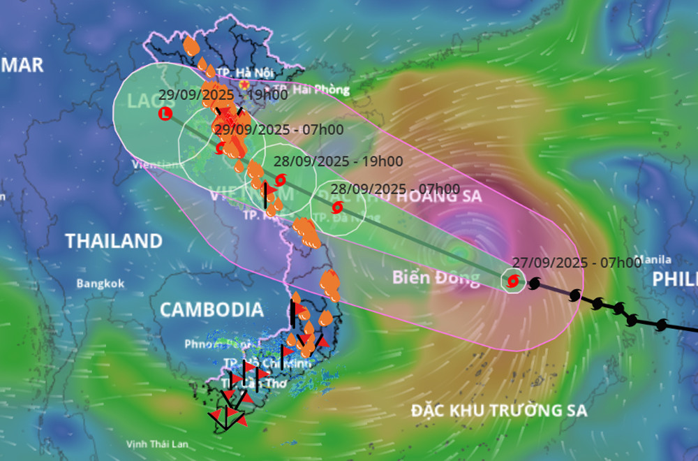
The movement direction of storm No. 10 Bualoi. Source: VNDMS
Experts assess that storm Bualoi is a very fast moving storm (about 30-35km/h, nearly double the average speed), with strong storm intensity, and tends to get stronger the closer it moves to shore; its range of influence is wide, and it can cause a combination of many types of natural disasters such as strong winds, heavy rains, floods, flash floods, landslides and coastal flooding.
According to initial statistics, due to the impact of storm Bualoi in the Philippines, at least 4 people died and more than 433,000 people were evacuated due to the risk of landslides and floods.
Vietnam and international forecasts for storm Bualoi
On the afternoon of September 25, the Department of Hydrometeorology issued a warning about a storm near the East Sea, forecasting that it would enter the area on the night of September 26 with a force of level 13, gusting to level 16. The storm is expected to move towards the Vietnamese mainland, concentrated in the Northern Delta and North Central regions. By the evening of September 26, the meteorological agency issued an emergency storm warning in the East Sea.
It is forecasted that on the morning of September 28, the storm will enter the central sea area and around evening to night of the same day will make landfall in the area from Nghe An to Northern Quang Tri.
Due to its wide circulation, the storm causes strong winds, directly affecting the coastal provinces and cities of the Northeast and North Central regions, from Thanh Hoa to Thua Thien Hue.
“This is a very strong storm, with winds on land that are likely to be equivalent to or exceed those of storm No. 5 (Kajiki) in 2025 that made landfall in Ha Tinh . At that time, storm No. 5 caused strong winds of level 8-10, gusting to level 12 in Nghe An - Ha Tinh,” said a meteorological expert.
At the time Bualoi was still in the East Sea, international forecasting centers gave scattered assessments. However, when the storm entered the East Sea, most forecasts said that the storm would move along the central coast and then make landfall in the provinces from Nghe An to Quang Tri, around September 29. After that, the centers adjusted the time of landfall earlier, to the night of September 28, but the assessment of the storm's intensity when it affects the mainland still had differences.
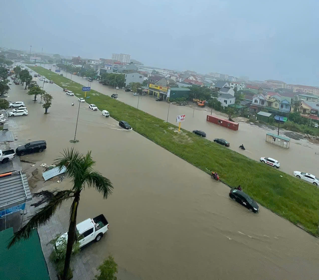
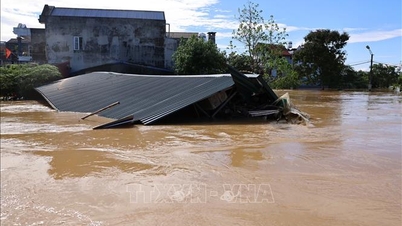
Storm No. 10 Bualoi has not yet made landfall, Nghe An has been experiencing heavy rain since the morning of September 27, many places are deeply flooded. Photo: T. Luong
Specifically, the forecast of the Japan Meteorological Center and the China Meteorological Center : The storm will affect Vietnam on the night of September 28, focusing on the Nghe An - North Quang Tri area, with an intensity of level 12 and gusts of level 15. The forecast of the Hong Kong Meteorological Center (China) : The storm will affect Vietnam on the night of September 28, focusing on the Ha Tinh - North Quang Tri area, with an intensity of level 13 and gusts of level 16.
US Navy forecast : On the night of September 28, the storm will affect Vietnam, focusing on the Quang Tri area, with an intensity of level 13 (however, US winds are measured in 1 minute, so level 13 is equivalent to level 12 of the Vietnamese wind scale, gusting to level 15).
Forecast using new AI technology (in collaboration with Weather New and Google): Forecast on the night of September 28, the storm will affect Vietnam, focusing on the Ha Tinh - Northern Quang Tri area, with intensity of level 10-12, gusting to level 14.
Marine impact warning
The North and Central East Sea (including Hoang Sa special zone) has strong winds of level 8-9, the area near the storm's eye has winds of level 10-13, gusts of level 16, waves of 6-8m high, the area near the storm's eye has waves of 8-10m, and the sea is very rough.
From the evening of September 27, the sea area from Thanh Hoa to Quang Ngai (including Hon Ngu island, Con Co special zone and Ly Son) will have winds gradually increasing to level 6-7, gusting to level 8-9, waves 3-5m high, and rough seas.

Ha Tinh implements sea ban from 7:30 a.m. on September 27. Photo: T. Luong
From early morning on September 28, the wind increased to level 8-9, the area near the storm center passed level 10-13, gusting to level 16, waves 5-7m high, violent sea (extremely destructive, extremely strong waves; sinking large tonnage ships).
For the Northern Gulf of Tonkin area (including Bach Long Vy, Van Don, Co To, Cat Hai and Hon Dau islands), it is forecasted that from early morning on September 28, the wind will gradually increase to level 6-7, then increase to level 8-9 (very rough seas, very dangerous for boats), gusting to level 11, waves 3-5m high, very rough seas.
Regarding storm surge : Coastal areas and islands from Ninh Binh - Ha Tinh have storm surges of 1-2m, Thanh Hoa and Nghe An 1.5-2m in particular. There is a high risk of flooding of dykes, coastal roads, and river mouths due to sea surges and very high storm waves on the evening and night of September 28.
The meteorological agency warns that the weather at sea and in coastal areas during the storm is extremely dangerous and unsafe for any vehicle or structure operating in the danger zone such as: cruise ships, passenger ships, transport ships, cages, rafts, aquaculture areas, dykes, embankments, coastal routes. Vehicles are at high risk of capsize, destruction, and flooding due to strong winds, big waves, and rising sea levels.
Impact of storms on land
From the afternoon of September 28, on land from Thanh Hoa to Northern Quang Tri, the wind gradually increased to level 6-7, then increased to level 8-9, near the storm's eye level 10-12 (wind force can knock down trees, houses, electric poles, causing very heavy damage), gusting to level 14; coastal areas from Quang Ninh to Ninh Binh, from Southern Quang Tri to Hue City, the wind gradually increased to level 6-7 (trees shake, difficult to go against the wind), gusting to level 8-9.
At the same time, from the night of September 27-30, in the North and the area from Thanh Hoa to Hue City, there is a possibility of widespread heavy rain with total rainfall ranging from 100-300mm, locally over 400mm; in the Northern Delta and from Thanh Hoa to Ha Tinh, it is common from 200-400mm, locally over 600mm.
In addition, from September 28-30, on rivers in the Northern region, from Thanh Hoa to Quang Tri, there will be a flood, the flood peak on the rivers is likely to be at alert level 1-2, in some places above alert level 3.
Vietnamnet.vn
Source: https://vietnamnet.vn/toan-canh-dien-bien-bao-so-10-bualoi-toi-dem-28-9-do-bo-nghe-an-bac-quang-tri-2446655.html

![[Photo] Prime Minister Pham Minh Chinh inspects and directs the work of overcoming the consequences of floods after the storm in Thai Nguyen](https://vphoto.vietnam.vn/thumb/1200x675/vietnam/resource/IMAGE/2025/10/08/1759930075451_dsc-9441-jpg.webp)

![[Photo] Prime Minister Pham Minh Chinh attends the World Congress of the International Federation of Freight Forwarders and Transport Associations - FIATA](https://vphoto.vietnam.vn/thumb/1200x675/vietnam/resource/IMAGE/2025/10/08/1759936077106_dsc-0434-jpg.webp)


![[Photo] Closing of the 13th Conference of the 13th Party Central Committee](https://vphoto.vietnam.vn/thumb/1200x675/vietnam/resource/IMAGE/2025/10/08/1759893763535_ndo_br_a3-bnd-2504-jpg.webp)


Comment (0)