
 |
| (Photo: National Center for Hydro-Meteorological Forecasting) |
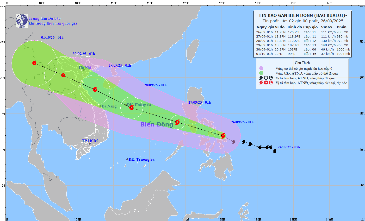
Regarding storm Bualoi, Dr. Hoang Phuc Lam, Deputy Director of the National Center for Hydro-Meteorological Forecasting, said that due to the storm's influence, the eastern sea area of the North and the middle of the East Sea has strong winds of level 6-7, then increasing to level 8-9, the area near the storm's center has winds of level 10-12, gusts of level 15, waves of 5-7m high, and rough seas.
The storm is moving in the West Northwest direction at a speed of 25-30km/h.
At 1:00 a.m. on September 26, the center of the storm was at about 11.9 degrees North latitude; 125.2 degrees East longitude, in the central region of the Philippines. The strongest wind near the center of the storm was level 11 (103-117 km/h), gusting to level 14. Moving in the West Northwest direction at a speed of 25-30 km/h.
It is forecasted that around the night of September 26, storm Bualoi will enter the eastern sea area of the Central East Sea, becoming storm number 10 in 2025.
At 1:00 a.m. on September 27, the center of the storm was at about 13.8 degrees North latitude; 118.9 degrees East longitude with the strongest wind at level 11, gusting to level 14. Moving in the West Northwest direction at a speed of 25-30 km/h and moving into the East Sea. The affected area is the East of the North and the middle of the East Sea. Natural disaster risk level 3.
As of September 28, the storm is located at about 15.8 degrees North latitude; 112 degrees East longitude with strong winds of level 12, gusts of level 15; moving in the West Northwest direction at a speed of about 25-30km/h with the possibility of strengthening. The affected area is the North and Central East Sea (including Hoang Sa special zone).
At 11:00 on September 28, the storm was located at about 18.3 degrees North latitude; 107.4 degrees East longitude with strong winds of level 12-13, gusting to level 16; moving in the West Northwest direction at a speed of about 25km/h and likely to continue to strengthen. The affected areas are the West of the North and Central East Sea (including Hoang Sa special zone), the South of Bac Bo Gulf, the sea area from South Quang Tri to Quang Ngai . Natural disaster risk level 3.
From the next 72 to 120 hours, the storm continued to move rapidly in the West Northwest direction, about 20-25km/h per hour, gradually weakening in intensity.
Due to the impact of storms, ships operating in the above-mentioned dangerous areas are likely to be affected by storms, whirlwinds, strong winds, and large waves.
The National Center for Hydro-Meteorological Forecasting said that from early morning on September 26 to morning on September 27, the Northeast region and Southern Phu Tho will have moderate rain, heavy rain and thunderstorms, locally very heavy rain in some places, with common rainfall of 30-70mm, locally over 150mm.
Many areas of heavy rain
The National Center for Hydro-Meteorological Forecasting said that from early morning on September 26 to morning on September 27, the Northeast region and Southern Phu Tho will have moderate rain, heavy rain and thunderstorms, locally very heavy rain in some places, with common rainfall of 30-70mm, locally over 150mm.
Warning of risk of heavy rain over 100mm in 3 hours.
In addition, on the day and night of September 26, the Northwest region, from Thanh Hoa to Da Nang , the Central Highlands and the South will have scattered showers and thunderstorms with rainfall of 10-30mm, locally heavy to very heavy rain of over 80mm. Warning of the risk of rain with an intensity of 60mm in 3 hours.
From the afternoon of September 27, heavy rain in the Northeast and Southern Phu Tho regions gradually decreased. The risk of natural disasters due to heavy rain, tornadoes, lightning, and hail is level 1.
"Heavy rain can cause flooding in low-lying areas, urban and industrial areas; flash floods on small rivers and streams, landslides on steep slopes; thunderstorms can cause tornadoes, lightning, hail and strong gusts of wind," noted Deputy Head of the Weather Forecasting Department Nguyen Huu Thanh.
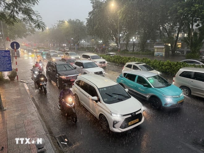 |
On the night of September 25 and early morning of September 26, the area from Ha Tinh to Da Nang and the Central Highlands will have scattered showers and thunderstorms, with some places experiencing heavy to very heavy rain. The rainfall from 7:00 p.m. on September 25 to 3:00 a.m. on September 26 was locally over 80mm in some places, such as: Vinh Tu station (Quang Tri) 12.2mm, Quan Tuong Dai station (Hue city) 185.6mm, Ho Thai Xuan station (Da Nang city) 83.6mm,...
From 9:00 p.m. on September 25 to 3:00 a.m. on September 26, the areas of Quang Ninh, Quang Tri provinces and Hue city had moderate and heavy rain such as Quat Dong (Quang Ninh) 67.8mm; Xuan Trach (Quang Tri) 85.8mm; Phu Bai Reservoir (Hue City) 79.8mm,...
Soil moisture models show that some areas in the above provinces are close to saturation (over 85%) or have reached saturation.
Beware of flash floods and landslides in Quang Ninh, Quang Tri and Hue city
According to the National Center for Hydro-Meteorological Forecasting, from 4:40 a.m. to 9:40 a.m. on September 26, the areas of Quang Ninh, Quang Tri provinces and Hue city continued to have rain with accumulated rainfall ranging from 20-40mm, in some places over 80mm.
Warning of the risk of flash floods on small rivers and streams, landslides on steep slopes in the above provinces, especially in the following communes/wards: Duong Hoa, Hai Ninh, Hai Son, Hoanh Mo, Mong Cai 3, Quang Duc, Quang Ha (Quang Ninh province); Phong Nha; Ben Quan, Bo Trach, Dong Le, Hieu Giang, Hoan Lao, Kim Dien, Minh Hoa, Tan Thanh, Tuyen Binh, Tuyen Hoa, Tuyen Lam, Tuyen Son (Quang Tri province); Binh Dien, Huong An, Kim Long, Phong Dien, Phong Thai, Phu Bai (Hue city). The level of risk of natural disasters due to flash floods, landslides, land subsidence due to heavy rain or level 1 flow.
Flash floods and landslides can have very negative impacts on the environment, threaten people's lives; cause local traffic congestion, affect the movement of vehicles; destroy civil and economic works, causing damage to production and socio-economic activities.
The hydrometeorological agency recommends that local authorities pay attention to reviewing bottlenecks and vulnerable locations in the area to have prevention and response measures.
Big waves and strong winds in many sea areas
According to the National Center for Hydro-Meteorological Forecasting, in Bach Long Vi special zone, there are strong winds of level 7, gusts of level 8; Phu Quy special zone has strong southwest winds of level 6, gusts of level 7, Huyen Tran station has strong gusts of level 10.
In the Gulf of Tonkin, the sea area from South Quang Tri to Hue city, the sea area from Lam Dong to Ca Mau, from Ca Mau to An Giang, the Gulf of Thailand, the central East Sea area, the sea area north of the South East Sea area (including Truong Sa special zone) there will be scattered showers and thunderstorms.
It is forecasted that on the day and night of September 26, the sea area from Khanh Hoa to Can Tho city, the central and southern East Sea (including Truong Sa special zone) will have strong winds of level 6, gusts of level 7-8, rough seas, and waves 2-4m high.
In the North of the North East Sea area (including the North of Hoang Sa special zone), the wind is level 5, sometimes level 6, gusting to level 7-8, rough sea, waves 2-4m high.
Weather in regions day and night September 26:
Northwest
- There will be scattered showers and thunderstorms, locally heavy rain; in the late afternoon and at night in South Phu Tho, there will be moderate rain, heavy rain and thunderstorms, locally very heavy rain, with the possibility of tornadoes, lightning and strong gusts of wind.
- Lowest temperature 22-25 degrees Celsius, some places below 21 degrees Celsius. Highest temperature 27-30 degrees Celsius.
Northeast
- There will be moderate to heavy rain and scattered thunderstorms, locally very heavy rain, with the possibility of tornadoes, lightning and strong gusts of wind. East wind level 2-3.
- Lowest temperature 23-26 degrees Celsius. Highest temperature 27-30 degrees Celsius, some places above 30 degrees Celsius.
Hanoi City
- There will be moderate to heavy rain and thunderstorms, locally very heavy rain, with the possibility of tornadoes, lightning and strong gusts of wind in thunderstorms. East wind level 2-3.
- Lowest temperature 23-25 degrees Celsius. Highest temperature 28-30 degrees Celsius.
Provinces and cities from Thanh Hoa to Hue
- There will be scattered showers and thunderstorms, locally heavy to very heavy rain, with the possibility of tornadoes, lightning, hail and strong gusts of wind.
- Lowest temperature 23-26 degrees Celsius. Highest temperature 27-30 degrees Celsius.
South Central Coast
- Scattered showers and thunderstorms, locally heavy rain, with the possibility of tornadoes, lightning, hail and strong gusts of wind. West to Southwest wind level 2-3.
- Lowest temperature 24-27 degrees Celsius. Highest temperature 30-33 degrees Celsius.
Central Highlands
- Scattered showers and thunderstorms, locally heavy rain (rain concentrated in the afternoon and night), thunderstorms with possibility of tornadoes, lightning, hail and strong gusts of wind. Southwest wind level 2-3.
- Lowest temperature 19-22 degrees Celsius. Highest temperature 25-28 degrees Celsius.
Southern region
- Scattered showers and thunderstorms, locally heavy rain (rain concentrated in the afternoon and evening), thunderstorms with possibility of tornadoes, lightning, hail and strong gusts of wind. Southwest wind level 2-3.
- Lowest temperature 24-27 degrees Celsius. Highest temperature 30-33 degrees Celsius.
Ho Chi Minh City
- There will be showers and thunderstorms in some places; in the late afternoon and evening there will be scattered showers and thunderstorms, locally heavy rain in some places, during thunderstorms there is a possibility of tornadoes, lightning, hail and strong gusts of wind. Southwest wind level 2-3.
- Lowest temperature 24-26 degrees Celsius. Highest temperature 31-33 degrees Celsius.
Source: VNA
Source: https://baodongnai.com.vn/xa-hoi/202509/bao-bualoi-sap-vao-bien-dong-nhieu-khu-vuc-tren-ca-nuoc-co-mua-lon-aff02a5/


![[Photo series] The first plane approaches the runway of Long Thanh Airport passenger terminal](https://vphoto.vietnam.vn/thumb/402x226/vietnam/resource/IMAGE/2025/9/26/dbafc11c36b34e68b7151da4e355cd8c)


![[Photo] Prime Minister Pham Minh Chinh receives Secretary of Shandong Provincial Party Committee (China) Lin Yu](https://vphoto.vietnam.vn/thumb/1200x675/vietnam/resource/IMAGE/2025/9/26/821396f0570549d39f33cb93b2e1eaee)


Comment (0)