
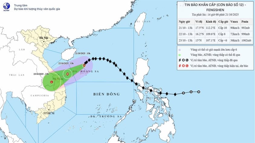
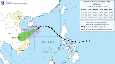
According to the National Center for Hydro-Meteorological Forecasting, at 1 p.m. on October 21, the storm center was at about 17.5°N - 112.2°E, in the sea north of Hoang Sa archipelago, about 450 km east-northeast of Da Nang . The strongest wind near the storm center was level 9 - 10 (75 - 102 km/h), gusting to level 12. The storm moved southwest at a speed of 10 - 15 km/h.
Forecast, by 13:00 on October 22, the storm will move in the West Southwest direction, speed 10 - 15 km/h, the center of the storm will be at about 16.2°N - 109.6°E, about 145 km East Northeast of Da Nang. Strong winds of level 8, gusts of level 10, gradually weakening. Danger zone: 15.0°–18.5°N; 108.5°–113.5°E. Disaster risk level 3 (sea area west of the North East Sea, including Hoang Sa; sea area from South Quang Tri to Quang Ngai ).
At 1 p.m. on October 23, the storm continued to move west-southwest at a speed of 10-15 km/h, moving inland through the area from Quang Tri to Da Nang, then gradually weakened into a tropical depression and then a low pressure area over the southern Laos area (15.0°N - 107.1°E). Wind force below level 6. Danger zone: 14.5°-18.0°N; west of longitude 111.0°E. Disaster risk level 3 (sea area from southern Quang Tri to Quang Ngai, including Con Co, Cu Lao Cham, Ly Son; coastal mainland of provinces from Quang Tri to Da Nang).
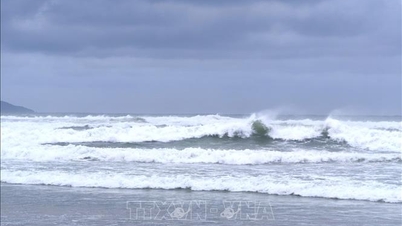
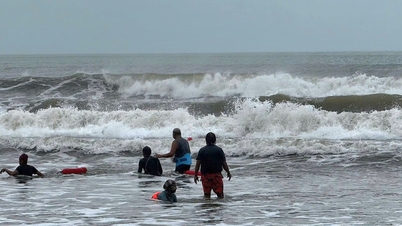
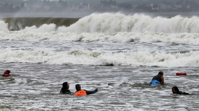
Due to the influence of the storm, the Northwestern sea area of the East Sea (including Hoang Sa archipelago) has strong winds of level 7-8, near the storm center level 9-10, gusting to level 12; waves 3-5 m high, near the storm center 5-7 m, very rough seas.
The sea area from Quang Tri to Quang Ngai (including Con Co, Cu Lao Cham, Ly Son) has strong winds of level 6, increasing to level 7 from the morning of October 22, near the storm center level 8, gusting to level 10; waves 3-5 m high, rough seas. Storm surges along the coast from Quang Tri to Da Nang can rise 0.3-0.5 m. All ships in the danger zone are at high risk of being affected by thunderstorms, whirlwinds, strong winds and big waves. The coast from Quang Tri to Da Nang needs to be on guard against big waves combined with high tides and surges causing flooding in low-lying areas and coastal erosion.
On land, from the afternoon of October 22, coastal provinces from Quang Tri to Da Nang will have winds gradually increasing to level 6, sometimes level 7, gusting to level 8-9.
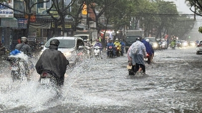
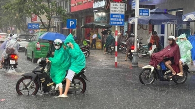
Due to the influence of storm circulation No. 12 combined with cold air and East wind, topographic effects, from noon on October 22 to October 27, the area from Ha Tinh to Quang Ngai will have heavy to very heavy rain, most concentrated from the afternoon of October 22 to the end of October 23. The area of Ha Tinh - North Quang Tri and Quang Ngai will have rainfall from 200 - 400 mm, some places over 500 mm; South Quang Tri - Da Nang will have rainfall from 500 - 700 mm, some places over 900 mm.
Warning: Heavy rains in the Central region are likely to last until the end of October 2025. There is a very high risk of flash floods and landslides in mountainous areas; flooding in low-lying and urban areas. Localities need to proactively and safely operate hydroelectric and irrigation reservoirs; and prepare response plans when river water levels from Quang Tri to Quang Ngai are likely to reach or exceed alert level 3. Level 3 natural disaster risk due to floods and inundations.
In addition, experts warn that it is necessary to guard against the risk of thunderstorms, tornadoes, and strong gusts of wind in areas affected by storm circulation, both before and during the storm's landfall.
Source: https://baotintuc.vn/xa-hoi/bao-so-12-cach-da-nang-450-km-mien-trung-co-mua-lon-20251021150158199.htm


![[Photo] Prime Minister Pham Minh Chinh received Mr. Yamamoto Ichita, Governor of Gunma Province (Japan)](https://vphoto.vietnam.vn/thumb/1200x675/vietnam/resource/IMAGE/2025/10/21/1761032833411_dsc-8867-jpg.webp)
![[Photo] Da Nang residents "hunt for photos" of big waves at the mouth of the Han River](https://vphoto.vietnam.vn/thumb/1200x675/vietnam/resource/IMAGE/2025/10/21/1761043632309_ndo_br_11-jpg.webp)
![[Photo] Prime Minister Pham Minh Chinh meets with Speaker of the Hungarian National Assembly Kover Laszlo](https://vphoto.vietnam.vn/thumb/1200x675/vietnam/resource/IMAGE/2025/10/20/1760970413415_dsc-8111-jpg.webp)


Comment (0)