
Could you tell us what the trend of storm number 12 will be when it enters the East Sea?
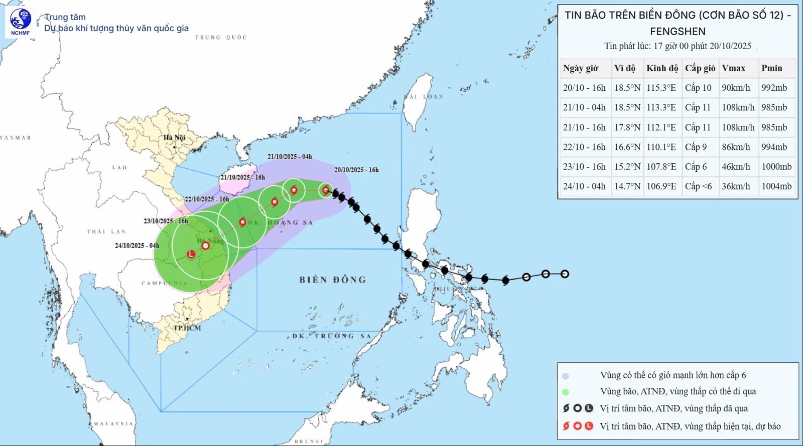
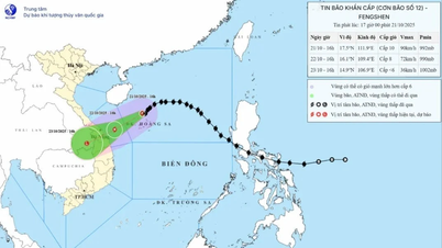
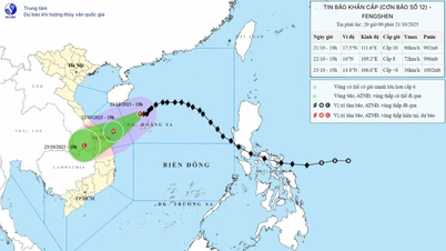
At 4:00 p.m. on October 20, the center of the storm was at about 18.5 degrees North latitude; 115.3 degrees East longitude, about 380 km East Northeast of Hoang Sa special zone. The strongest wind near the center of the storm was level 9 - 10 (75 - 102 km/h), gusting to level 12. Moving in the West Northwest direction, speed about 20 km/h.
Immediately after entering the East Sea, the storm moved in the West-Northwest direction at a speed of about 20 km/hour and tended to strengthen, reaching level 11, gusting to level 13 in the next 24 hours.
From October 22 onwards, when approaching the sea northwest of Hoang Sa, the storm began to gradually shift to the southwest, slowing down, and gradually weakening before making landfall.
Thus, it can be seen that storm No. 12 moves in a curved trajectory, initially moving West Northwest - West, then gradually moving to the Southwest when approaching the Central region.
What are the possible impacts of storm No. 12 on mainland Vietnam, sir?
According to the latest forecast, storm No. 12 will make landfall in the area from Da Nang to Quang Ngai around October 23, with strong winds of level 6, gusting to level 8, then weaken into a tropical depression on land.
Storm circulation combined with cold air and easterly wind disturbances will cause widespread heavy rain in provinces from Ha Tinh to Quang Ngai.
Rainfall from Ha Tinh to Northern Quang Tri and Quang Ngai ranges from 200 - 400 mm, with some places over 500 mm; from Southern Quang Tri to Da Nang ranges from 500 - 700 mm, with some places over 900 mm.
Prolonged heavy rains can cause flash floods, landslides in mountainous areas, and deep flooding in low-lying and urban areas. This is the main scenario assessed, although the storm weakens quickly after reaching the shore, the circulation combined with cold air will cause widespread rain and flooding that will last until the end of October.
Sir, when a storm meets cold air, how will this affect the storm's path and strength?
Cold air from the North flowing down to the East Sea while the storm moves near the shore will strongly affect the direction and intensity of the storm.
Specifically, the cold air flow causes the storm to gradually shift to the southwest and weaken rapidly as it approaches land. However, the interaction between the storm circulation, cold air and the east wind causes heavy rain to increase over a wide area of the Central region.
In other words, cold air reduces the storm's wind strength but increases the risk of flooding, especially in the provinces from Quang Tri to Quang Ngai.
When making landfall, how strong will storm No. 12 be, how much rain will it bring, and what will be its impact on people, sir?
When making landfall in the Da Nang - Quang Ngai region on October 23, storm No. 12 is forecast to be level 6, gusting to level 8, then weakening into a tropical depression.
From the night of October 22 to October 26, heavy rain will continue. Total rainfall in Ha Tinh to Northern Quang Tri and Quang Ngai will be about 200 - 400 mm, locally over 500 mm; focusing on the area from Southern Quang Tri to Da Nang City, generally 500 - 700 mm, locally over 900 mm. Heavy rain in the Central region is likely to last until the end of October.
Regarding floods, from October 23 to 30, on rivers from Quang Tri to Quang Ngai, there will be a major flood, with peak water levels reaching or exceeding alert level 3, causing deep and widespread flooding, along with a high risk of flash floods and landslides. The disaster risk level is forecast at level 3.
Therefore, people in the Central region, especially provinces from Ha Tinh to Quang Ngai, need to proactively prepare plans to prevent heavy rain, flooding and landslides, ensuring safety for people and property.
Thank you very much!
Source: https://baotintuc.vn/xa-hoi/chuyen-gia-nhan-dinh-ve-con-bao-so-12-20251020182508983.htm


![[Photo] Prime Minister Pham Minh Chinh meets with Speaker of the Hungarian National Assembly Kover Laszlo](https://vphoto.vietnam.vn/thumb/1200x675/vietnam/resource/IMAGE/2025/10/20/1760970413415_dsc-8111-jpg.webp)

![[Photo] Prime Minister Pham Minh Chinh received Mr. Yamamoto Ichita, Governor of Gunma Province (Japan)](https://vphoto.vietnam.vn/thumb/1200x675/vietnam/resource/IMAGE/2025/10/21/1761032833411_dsc-8867-jpg.webp)
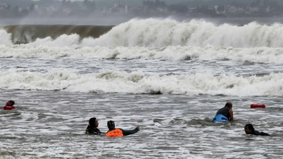
![[Photo] Da Nang residents "hunt for photos" of big waves at the mouth of the Han River](https://vphoto.vietnam.vn/thumb/1200x675/vietnam/resource/IMAGE/2025/10/21/1761043632309_ndo_br_11-jpg.webp)


Comment (0)