
According to Deputy Director of the Provincial Hydrometeorological Station - Dang Hoang Lam, the highest daily peak water level on river banks and canals in the province will gradually rise from October 19-22, rise slowly and change little on October 22-23, fall slowly on October 24, and gradually fall from October 25-27.
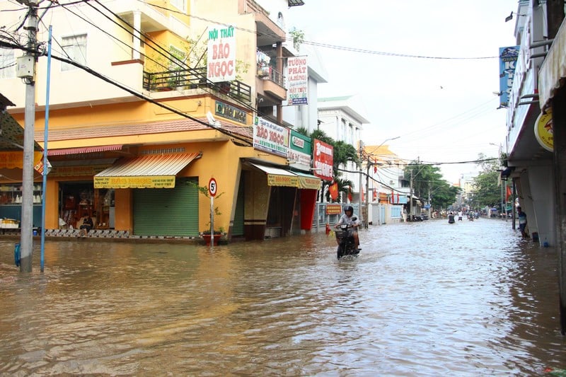 |
| High tides are likely to flood low-lying areas across the province. |
The highest peak water level at stations during this high tide occurred on October 22-23 (September 2-3, lunar calendar). My Thuan station was 27cm higher than alert level III (BĐIII), Cho Lach station was 8cm higher than BĐIII, Tra Vinh station was 6cm higher than BĐIII, the remaining stations were 2cm lower than BĐII to 3cm higher than BĐII.
Specifically, from October 22-23: My Thuan and Cho Lach stations have peak times at 3:30-6:30 and 16:00-19:30. My Hoa, Tra Vinh and Cau Quan stations have peak times at 3:00-5:00 and 15:30-18:00. An Thuan, Binh Dai and Ben Trai stations have peak times at 1:30-3:30 and 14:00-17:00.
Recommendation: Localities need to have plans to protect and reinforce the dike system, raise furniture and belongings, and proactively deal with flooding and landslides caused by high tides combined with upstream floods, rain and other factors.
The possibility of flooding low-lying areas across the province. Flooding is likely to have a negative impact on the environment, road and waterway traffic activities, residential areas; fruit growing areas, livestock areas, aquaculture areas; especially the upstream areas of the province from Phu Tuc commune (Tien river), Tien Thuy commune - Vinh Thanh commune - Phuoc My Trung commune (Ham Luong river), Thanh Thoi commune - Nhi Long commune - Long Duc ward (Co Chien river), Tan Hoa commune (Hau river) and above; the possibility of deep flooding in areas along Tien river, Ham Luong river, Co Chien river, Mang Thit river, Hau river, areas outside the dyke, some roads in Thanh Duc ward; Phuoc Hau ward, Long Chau ward, Cho Lach commune...; other low-lying areas, weak dyke areas - without and outside the dyke, areas of islets, islands, riverside areas, coastal areas.
The possibility of flooding from October 18-25 is from 5-40cm, the depth of flooding will gradually increase according to the rising water level with the tide. Warning about natural disaster risk level: Level 2.
News and photos: NGUYEN KHANG
Source: https://baovinhlong.com.vn/thoi-su/202510/dinh-trieu-cuong-xuat-hien-tu-ngay-22-2310-a233675/


Comment (0)