
Due to the influence of storm No. 10, at Ly Son station (Quang Ngai), there were strong winds of level 7, gusts of level 8; Bac Trach station (Quang Tri) had strong winds of level 8, gusts of level 10; Hoanh Son station (Ha Tinh) had strong winds of level 6, gusts of level 9; Van Ly station (Ninh Binh) had strong winds of level 7, gusts of level 9; Hon Ngu station (Nghe An) had strong winds of level 6, gusts of level 8; Con Co station (Quang Tri) had strong winds of level 7, gusts of level 10; Bach Long Vi station had strong winds of level 7, gusts of level 9; ...
According to the National Center for Hydro-Meteorological Forecasting, at 1:00 p.m. on September 28, the center of the storm was located at about 17.1 degrees North latitude; 108.3 degrees East longitude, on the sea area of Quang Tri - Da Nang city, about 90km East Northeast of Hue city, about 190km South Southeast of North Quang Tri. The strongest wind near the center of the storm was level 12 (118-133km/h), gusting to level 15. Moving in the West Northwest direction at a speed of about 25km/h.
This is a fast-moving storm with strong intensity and wide range of influence, which can cause combined impacts of many types of natural disasters such as strong winds, heavy rains, floods, flash floods, landslides and coastal flooding.
Forecast by 1:00 a.m. on September 29, the storm is forecast to be in the sea area of Nghe An - Northern Quang Tri with strong winds of 12, gusts of level 15; moving in the West Northwest direction with about 20-25 km/h. The affected areas are the sea area west of the Northern East Sea; the sea area from Thanh Hoa to Da Nang city (including Hon Ngu island, Con Co special zone); Northern Bac Bo Gulf (including Bach Long Vi special zone, Van Don, Co To, Cat Hai and Hon Dau island) with risk level 3; the coastal mainland area from Nghe An to Northern Quang Tri with risk level 4.
By 1 p.m. on September 29, the storm was in the Upper Laos region with winds of level 7, gusts of level 9; moving in the West Northwest direction at a speed of about 20-25 km/h and entering the mainland of Thanh Hoa - Northern Quang Tri provinces and gradually weakening into a tropical depression. The affected area is the sea from Thanh Hoa to Hue City (including Hon Ngu Island, Con Co Special Zone). Northern Bac Bo Gulf (including Bach Long Vi Special Zone, Van Don, Co To, Cat Hai and Hon Dau Island). Risk level 3.
At 1:00 a.m. on September 30, the storm in the Upper Laos region with winds below level 6, moving in the West Northwest direction at about 20-25 km/h, continued to weaken into a low pressure area.
Due to the influence of the storm, the western sea area of the North East Sea has strong winds of level 6-8, waves of 4-6m high, and rough seas.
The sea area from Thanh Hoa to Quang Ngai (including Hon Ngu island, Con Co special zone and Ly Son) has strong winds of level 8-10, the area near the storm's center has winds of level 11-12, gusts of level 15, waves of 6-8m high, very rough seas (extremely destructive, extremely strong waves. Sinking large tonnage ships).
The Northern Gulf of Tonkin area (including Bach Long Vi, Van Don, Co To, Cat Hai and Hon Dau islands) has strong winds of level 6-7, then increasing to level 8-9 (very rough seas, very dangerous for boats), gusts of level 11, waves 3-5m high, very rough seas.
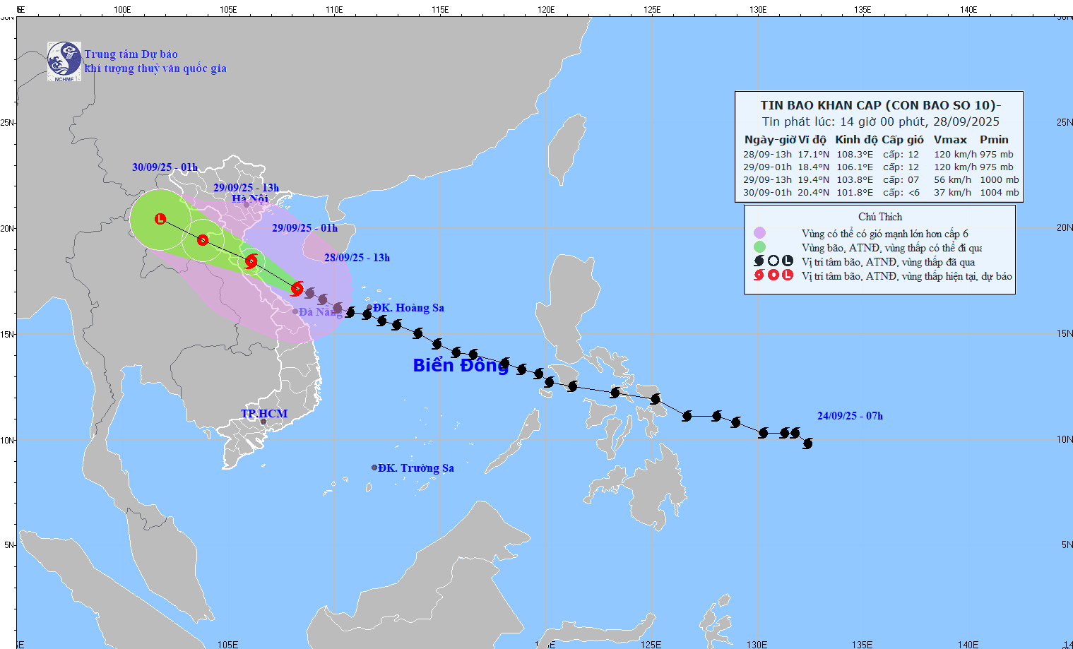
Coastal areas and islands from Hung Yen to Ha Tinh have storm surges of 0.5-1.5m, especially Thanh Hoa and Nghe An where they are 1-1.5m high. There is a high risk of flooding on the morning of September 29 in low-lying areas, coastal roads, and river mouths due to storm surges, waves, and rain.
Warning: The weather at sea and in coastal areas during the storm is extremely dangerous and unsafe for any vehicle or structure operating in the danger zone such as: cruise ships, passenger ships, transport ships, cages, rafts, aquaculture areas, dykes, embankments, coastal routes. Vehicles are at high risk of capsize, destruction, and flooding due to strong winds, big waves, and rising sea levels.
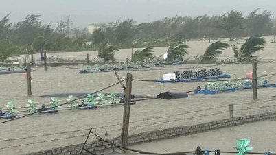
On land: The area from South Quang Tri to Hue city has strong winds of level 6-7 (trees shake, difficult to go against the wind), gusts of level 8-9. The area from Thanh Hoa to North Quang Tri has winds gradually increasing to level 6-7, then increasing to level 8-9, the area near the storm's center has winds of level 10-12 (winds can knock down trees, houses, electric poles, causing very heavy damage), gusts of level 14. The coastal area from Quang Ninh to Ninh Binh has winds gradually increasing to level 6-7, gusts of level 8-9, in some places level 8, gusts of level 10.
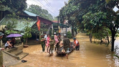
From the afternoon of September 28 to September 30, in the North and the area from Thanh Hoa to Da Nang city, there will be moderate rain, heavy rain, and in some places very heavy rain with total rainfall from 100-300mm, locally over 450mm; in the Northern Delta, Phu Tho, the south of Son La and Lao Cai provinces, from Thanh Hoa to the north of Quang Tri, there will be heavy to very heavy rain with total rainfall from 200-400mm, locally over 600mm. Warning of the risk of heavy rain over 200mm/3 hours.
Monitor storm developments to proactively respond
To proactively respond to storms, the Department of Dyke Management and Natural Disaster Prevention and Control of the Ministry of Agriculture and Environment provides guidance on skills to respond to storms and floods after storms.
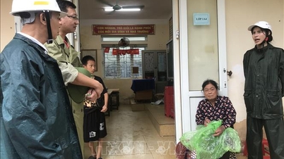
Accordingly, to ensure the safety of life and property against storms and floods after storms, people should not be subjective, regularly monitor forecasts, warnings, and update storm developments to proactively prevent and avoid them.
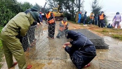
People need to ensure the safety of boats at anchor, protect fishery cages and rafts, especially people on islands; absolutely do not stay on anchored boats, tourist boats, watchtowers, cages and rafts, aquaculture areas when storms make landfall; ensure safety when traveling during the rainy and stormy season: regularly monitor weather developments, warn of natural disasters, proactively postpone or cancel trips when the weather is bad to ensure safety; avoid traveling to coastal areas, islands, mountainous areas or places at risk of landslides and flash floods. Absolutely do not go out when a storm is making landfall, except in emergency cases and with specific instructions from authorities; determine the safest shelter for all family members; proactively evacuate when necessary or at the request of local authorities.
Along with that, people proactively stock up on food, drinking water, medicine, and necessary supplies; reinforce and prop up houses; prune tree branches; remove billboards and posters that pose a safety risk; ensure the safety of construction works; reinforce livestock and poultry barns; and take advantage of early harvesting of agricultural and aquatic products according to the motto "green at home is better than old in the fields".
In addition, people need to be on guard against rain, floods, inundation in some low-lying areas, urban areas and flash floods, landslides in mountainous areas; be on guard against rising water in coastal areas, river mouths; raise assets, keep important documents in safe places, move vehicles to higher terrain; proactively clear drainage near their homes and residential areas to create flood escape routes; notify the authorities when there are incidents of clogged drainage, deep flooding; do not park in areas at risk of flooding; be on guard against flooding in apartment basements. At the same time, save rescue phone numbers for use in emergencies.
Beware of flash floods and landslides in 7 Central provinces
The National Center for Hydro-Meteorological Forecasting said that from 2:30 p.m. to 7:30 p.m., the provinces from Thanh Hoa to Quang Ngai will continue to have rain. Warning of the risk of flash floods on small rivers and streams, and landslides on steep slopes in the above provinces.
Specifically, the common accumulated rainfall is as follows: from Thanh Hoa to Quang Tri from 50-90mm, some places over 100mm; Hue city from 30-50mm, some places over 80mm; from Da Nang city to Quang Ngai from 10-30mm, some places over 50mm.
Warning of the risk of flash floods on small rivers and streams, landslides on steep slopes in many communes/wards: Thanh Ky, Truong Lam, Xuan Binh; Cong Chinh, Hoa Quy, Mau Lam, Nhu Thanh, Nhu Xuan, Thang Loc, Thanh Phong, Thanh Quan, Van Xuan, Xuan Chinh, Xuan Thai, Yen Tho (Thanh Hoa province); Bich Hao, Chau Binh, Chau Hong, Chau Tien, Dai Dong, Dong Hieu, Hoa Quan, Hung Chan, Kim Bang, Muong Ham, Nghia Dong, Que Phong, Quy Hop, Son Lam, Tam Dong, Tan Ky, Thuan Trung, Van An, Xuan Lam; Anh Son, Anh Son Dong, Cat Ngan, Chau Loc, Giai Xuan, Hanh Lam, Minh Hop, Mon Son, Muong Chong, Muong Quang, Nghia Dan, Nghia Hanh, Nghia Hung, Nghia Khanh, Tay Hieu, Thai Hoa, Quy Chau, Tam Hop, Tan An, Tan Phu, Thanh Binh Tho, Thong Thu, Tien Dong, Tien Phong, Vinh Tuong, Yen Xuan; Binh Chuan, Cam Phuc, Con Cuong, Mau Thach, Na Ngoi, Nga My, Nhan Hoa, Tri Le, Yen Hoa (Nghe An province);
Can Loc, Co Dam, Duc Dong, Duc Quang, Huong Binh, Huong Do, Huong Khe, Huong Pho, Huong Son, Huong Xuan, Kim Hoa, Nghi Xuan, Bac Hong Linh, Nam Hong Linh, Phuc Trach, Son Giang, Son Hong, Son Kim 2, Son Tay, Son Tien, Thuong Duc, Truong Luu, Vu Quang; Cam Due, Duc Minh, Duc Tho, Ha Linh, Hong Loc, Ky Hoa, Ky Lac, Ky Thuong, Mai Hoa, Mai Phu, Song Tri, Son Kim 1, Thach Khe, Tu My, Tung Loc; Cam Hung, Cam Lac, Cam Trung, Cam Xuyen, Ky Khang, Ky Van, Ky Xuan, Hai Ninh, Hoanh Son, Vung Ang, Thach Xuan (Ha Tinh province); A Doi, Ai Tu, Ba Long, Ben Quan, Cam Lo, Con Tien, Dakrong, Dan Hoa, Hai Lang, Hieu Giang, Huong Hiep, Huong Lap, Huong Phung, Khe Sanh, Kim Dien, Kim Phu, La Lay, Lao Bao, Nam Hai Lang, Quang Tri, Ta Rut, Tan Thanh, Trieu Phong, Truong Son, Tuyen Binh, Tuyen Hoa, Tuyen Lam; Dong Le, Hoa Trach, Kim Ngan, Lia, Minh Hoa, Phu Trach, Tan Lap, Tuyen Phu, Tuyen Son; Bac Trach, Bo Trach, Dong Trach, Hoan Lao, Le Ninh, Nam Ba Don, Nam Trach, Dong Son, Phong Nha, Quang Ninh, Quang Trach, Tan Gianh, Trung Thuan, Truong Ninh, Truong Phu (Quang Tri province);
A Luoi 1, A Luoi 2, A Luoi 3, A Luoi 4, A Luoi 5, Binh Dien, Chan May - Lang Co, Hung Loc, Khe Tre, Loc An, Long Quang, Nam Dong, Huong An, Huong Tra, Kim Long, Kim Tra, Phong Dien, Phong Thai Ward, Phu Bai, Phu Loc, Vinh Loc (Hue city); Avuong, Ba Na, Ben Giang, Ben Hien, Chien Dan, Dai Loc, Dong Duong, Dong Giang, Duc Phu, Duy Xuyen, Ha Nha, Hiep Duc, Hoa Tien, Hoa Vang, Hung Son, La Ee, Nong Son, Nui Thanh, An Khe, Hai Van, Hoa Khanh, Lien Chieu, Son Tra, Phu Ninh, Phu Thuan, Phuoc Tra, Que Phuoc, Que Son, Que Son Trung, Son Cam Ha, Song Kon, Song Vang, Tam Anh, Tam My, Tam Xuan, Tay Giang, Tay Ho, Thang Phu, Thanh Binh, Thanh My, Thu Bon, Thuong Duc, Tien Phuoc, Tra Lien, Viet An; Dac Pring, La Dee, Lanh Ngoc Nam Giang, Phuoc Chanh, Phuoc Hiep, Phuoc Nang, Phuoc Thanh, Tra My, Tra Tan; Kham Duc, Tra Giap, Tra Leng, Tra Tap, Tra Van (Da Nang city); Binh Chuong, Binh Minh, Dak Plo, Dong Tra Bong, Tay Tra Bong, Thanh Bong, Tra Bong; Ba Gia, Ba Vinh, Ca Dam, Dinh Cuong, Mang But, Minh Long, Mo Duc, Nghia Giang, Ngoc Linh, Phuoc Giang, Son Ha, Son Ha, Son Linh, Son Mai, Son Tay, Son Tay Ha, Son Tay Thuong, Son Thuy, Son Tinh, Tay Tra, Tra Giang, Truong Giang, Ve Giang, Xop (Quang Ngai province)
Level of natural disaster risk due to flash floods, landslides, land subsidence due to rain, floods or water flow level 1, Hue city level 2.
Flash floods and landslides can have very negative impacts on the environment, threaten people's lives; cause local traffic congestion, affect the movement of vehicles; destroy civil and economic works, causing damage to production and socio-economic activities.
The hydrometeorological agency recommends that local authorities pay attention to reviewing bottlenecks and vulnerable locations in the area to have prevention and response measures.
From 1:00 p.m. on September 27 to 1:00 p.m. on September 28, the provinces from Thanh Hoa to Quang Ngai had moderate rain, heavy rain, and very heavy rain in some places such as: Cam Luong (Thanh Hoa) 62.6mm; Yen Thuong (Nghe An) 110.2mm; Huong Vinh (Ha Tinh) 173mm; Ta Rut (Quang Tri) 275mm; Huong Nguyen (Hue city) 490.4mm; Que Phuoc (Da Nang city) 206mm; Binh Khuong (Quang Ngai) 114.8mm;...
Soil moisture models show that some areas in the above provinces are close to saturation (over 85%) or have reached saturation.
Source: https://baotintuc.vn/xa-hoi/du-bao-13-gio-ngay-299-bao-so-10-di-vao-dat-lien-cac-tinh-thanh-hoabac-quang-tri-va-suy-yeu-dan-20250928155813925.htm


![[Photo] National Assembly Chairman Tran Thanh Man chairs the 8th Conference of full-time National Assembly deputies](https://vphoto.vietnam.vn/thumb/1200x675/vietnam/resource/IMAGE/2025/9/29/2c21459bc38d44ffaacd679ab9a0477c)

![[Photo] Many streets in Hanoi were flooded due to the effects of storm Bualoi](https://vphoto.vietnam.vn/thumb/1200x675/vietnam/resource/IMAGE/2025/9/29/18b658aa0fa2495c927ade4bbe0096df)
![[Photo] General Secretary To Lam chairs the meeting of the Central Steering Committee on preventing and combating corruption, waste and negativity](https://vphoto.vietnam.vn/thumb/1200x675/vietnam/resource/IMAGE/2025/9/29/fb2a8712315d4213a16322588c57b975)


Comment (0)