
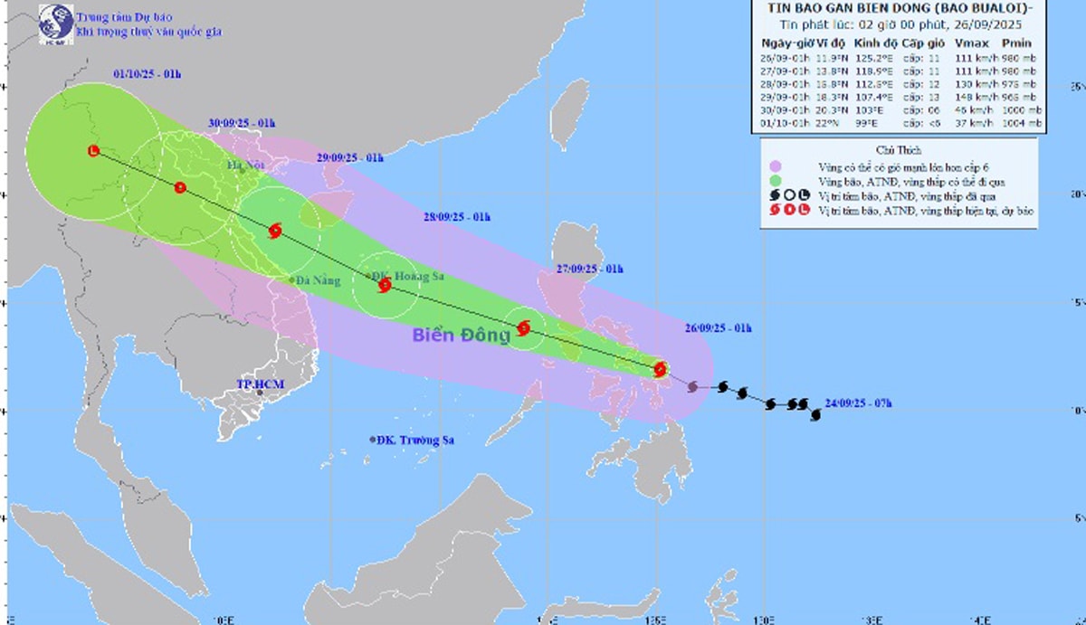
At 1:00 a.m. on September 26, the center of the storm was at about 11.9 degrees North latitude; 125.2 degrees East longitude, in the central region of the Philippines. The strongest wind near the center of the storm was level 11 (103 - 117 km/h), gusting to level 14. Moving in the West Northwest direction at a speed of 25 - 30 km/h.
It is forecasted that around the night of September 26, storm Bualoi will enter the eastern sea area of the central East Sea, becoming storm number 10 in 2025.
Forecast, by 1:00 a.m. on September 27, the center of the storm is at about 11.5 degrees North latitude; 116.5 degrees East longitude with strong winds of level 11, gusts of level 14; moving in the West Northwest direction at a speed of about 25 - 30 km/hour, moving into the East Sea and likely to strengthen. The affected area is the East of the North and the middle of the East Sea (including Hoang Sa special zone).
At 1:00 a.m. on September 28, the storm was located at about 12.0 - 19.0 degrees North latitude; 110.0 degrees East longitude with strong winds of level 12, gusts of level 15; moving in the West Northwest direction at a speed of about 25-30 km/hour and likely to strengthen. The affected area is the North and Central East Sea (including Hoang Sa special zone), the sea area from Quang Tri to Quang Ngai . Natural disaster risk level 3.
From the next 72 to 120 hours, the storm continued to move rapidly in the West-Northwest direction, traveling about 15-20 km per hour and gradually weakening.
Due to the impact of the storm from the evening of September 26, the sea area east of the North and Central East Sea has strong winds of level 6-7, then increasing to level 8-9, the area near the storm center has winds of level 10-12, gusts of level 15, waves from 5.0-7.0m high, rough seas.
Vessels operating in the above mentioned dangerous areas are susceptible to the impact of storms, whirlwinds, strong winds and large waves.
PVSource: https://baohaiphong.vn/du-bao-dem-nay-26-9-bao-bualoi-se-vao-bien-dong-va-tro-thanh-con-bao-so-10-nam-2025-521811.html


![[Photo] Prime Minister Pham Minh Chinh chairs a meeting of the Government Standing Committee on overcoming the consequences of natural disasters after storm No. 11](https://vphoto.vietnam.vn/thumb/1200x675/vietnam/resource/IMAGE/2025/10/09/1759997894015_dsc-0591-jpg.webp)
![[Photo] Prime Minister Pham Minh Chinh chairs the Conference to deploy the National Target Program on Drug Prevention and Control until 2030](https://vphoto.vietnam.vn/thumb/1200x675/vietnam/resource/IMAGE/2025/10/09/1759990393779_dsc-0495-jpg.webp)


Comment (0)