
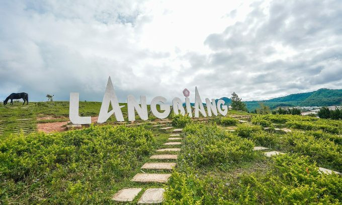
Lang Biang is a mountain range in Lac Duong district, Lam Dong province. This location is about 12 km north of Da Lat city and is a famous tourist destination.
On July 24, three male tourists from Ho Chi Minh City were trekking Lang Biang along the trail and got lost in the jungle. That afternoon, the three tourists lost their way and called 114 for help. The police of Lac Duong district and a search and rescue team of about 30 people divided into many teams, following the trails into the forest to search in heavy rain and slippery roads.
Mr. Nguyen Nhat Vu, Deputy General Director of Dalattourist, said that cases of getting lost in Lang Biang range are rare. The terrain here is gentle, easier to trek than Ta Nang - Phan Dung, most of the climbing routes have instructions. The difficulty of conquering the peaks in Lang Biang also depends on the climbing route and the peak that tourists choose to trek.
Lang Biang range has two peaks including Ong mountain at 2,124 m high - located in Lang Biang tourist area and Ba mountain at 2,167 m high - under the management of Bidoup National Park.
Below are some safety information shared by Mr. Nguyen Nhat Vu for tourists who want to explore Lang Biang range.
Directions of movement
There are two ways to explore Lang Biang range. If you want to sightsee, visitors to Lang Biang tourist area will take a Jeep along the trail to Radar Hill at an altitude of 1,929 m. From here, visitors can experience trekking to the top of Ong Mountain. The trekking route in the tourist area has signs, making it easy to navigate. Because it is under the management of the tourist area, this location has operating hours from 7:30 to 17:00.
Independent trekkers often choose to conquer Ba Mountain. The average trekking time from the foot of the mountain to the top takes about three hours, divided into two sections. First, visitors follow the asphalt road that the Jeep travels to take passengers to Radar Hill, go about 3-4 km to the intersection with the Bidoup National Park checkpoint, then turn right onto the trail, following this road will lead to the top of the mountain. This route is on Google Map, visitors can open it to see the directions. However, the road in this section is steep, with many places missing, making it easy to get lost.
When moving to the location marked "bird watching point", visitors are only 960 meters from the top of Ba Mountain. From here, visitors continue to climb many high and steep stairs. This section of the road is under a very dense and wet forest canopy, which is slippery.
Tourists who choose to trek Ba Mountain should hire a local guide to show them the way if they are not familiar with the terrain and do not have much experience trekking in the forest. Currently, there are many Lang Biang trekking tours for tourists to choose from, priced at around 900,000 VND per person.
When to trek Lang Biang
There are two seasons in Langbiang, the rainy season starts from April to October, the dry season from November to March. Currently, the mountain range is in the rainy season with many mosquitoes, leeches, the forest land is wet, slippery and difficult to walk. To ensure safety, visitors should choose to go in the dry season, this is also the time when cherry blossoms bloom.
Tourists should depart early in the morning to take the initiative in sightseeing time, and get down to the foot of the mountain before sunset if traveling on a daily schedule. If you want to camp overnight, you should also depart early in the morning and stop to set up camp when the sun goes down, hunting for clouds the next morning. Moving in the forest at night will increase the risk of getting lost.
Things to prepare
Visitors should wear a pair of sneakers with good grip. The forest path can be a bit slippery, so bring a trekking pole for safety.
Visitors should prepare a thin raincoat or waterproof jacket because sudden rain showers can occur in the forest even when it is not the rainy season.
HQ (according to VnExpress)Source: https://baohaiduong.vn/luu-y-an-toan-khi-leo-lang-biang-388530.html
![[Photo] Hanoi morning of October 1: Prolonged flooding, people wade to work](https://vphoto.vietnam.vn/thumb/1200x675/vietnam/resource/IMAGE/2025/10/1/189be28938e3493fa26b2938efa2059e)


![[Photo] Panorama of the cable-stayed bridge, the final bottleneck of the Ben Luc-Long Thanh expressway](https://vphoto.vietnam.vn/thumb/1200x675/vietnam/resource/IMAGE/2025/9/30/391fdf21025541d6b2f092e49a17243f)
![[Photo] President Luong Cuong receives President of the Cuban National Assembly Esteban Lazo Hernandez](https://vphoto.vietnam.vn/thumb/1200x675/vietnam/resource/IMAGE/2025/9/30/4d38932911c24f6ea1936252bd5427fa)
![[Photo] The 1st Congress of Phu Tho Provincial Party Committee, term 2025-2030](https://vphoto.vietnam.vn/thumb/1200x675/vietnam/resource/IMAGE/2025/9/30/1507da06216649bba8a1ce6251816820)


Comment (0)