
At the meeting of the National Civil Defense Steering Committee, at noon on October 22, the Department of Meteorology and Hydrology ( Ministry of Agriculture and Environment ) reported on the situation of storm No. 12.
According to the Department of Hydrometeorology, due to the impact of cold air, the intensity of storm No. 12 is not too strong (maximum only reaches level 10), and cannot increase in intensity like storms No. 10 (Bualoi) and No. 11 (Matmo). When entering the Hoang Sa special zone, the storm was blocked by a cold air mass, so it changed direction and moved slowly.
“Although the storm's intensity is not too strong, it is still forecast to cause heavy rain on land, because the storm's circulation brings a large amount of moisture from the East Sea to the mainland, combined with strong northeast winds in the East Sea and the Gulf of Tonkin and east wind disturbances,” the report of the Department of Meteorology and Hydrology stated.

The representative of the meteorological agency also said that the convergence of wind and moisture (water vapor) of the three above mentioned systems is stronger due to the wind-blocking effect of the Truong Son range (terrain factor) in the Central region, causing the rain to intensify and last for many days, even after the storm dissipates.
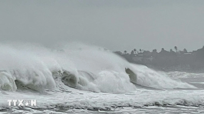
The Department of Hydrometeorology also warned that from the afternoon of October 22, on the mainland along the coast from Quang Tri to Da Nang City, winds will gradually increase to level 6-7, gusting to level 8-9. The strongest winds will be around tonight until tomorrow morning, October 23. People need to be on guard against the risk of thunderstorms, tornadoes, and strong gusts in the storm's circulation area, both before and during the storm's landfall.
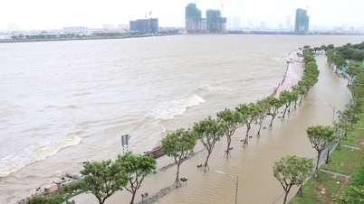
There will be 2 heavy rains. The first period from the night of October 22 to October 24, due to the combined influence of storm No. 12, cold air and East wind, the area from Quang Tri to Da Nang will have common rainfall of 400-600mm, some places will have very heavy rain over 800mm, rainfall intensity exceeding 200mm in 3 hours. Ha Tinh and Quang Ngai provinces will have rain of 100-250mm, locally exceeding 400mm. This period of rain requires special attention to the risk of flooding in urban and industrial areas due to heavy rain combined with rising sea levels causing slow drainage.
The second wave from October 25 to 27, cold air combined with East wind continued to cause heavy rain in the Central provinces. Particularly in Quang Tri and Hue, rainfall was 200-300mm, locally over 500mm. Ha Tinh, Da Nang City and Quang Ngai had rain of 100-200mm, some places over 300mm. After October 27, rain is likely to continue in the Central region.
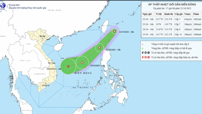
According to the National Center for Hydro-Meteorological Forecasting, updated to 13:00 on October 22, the storm center is at about 17.1 degrees North latitude - 110.2 degrees East longitude, about 230km East Northeast of Da Nang City. Strongest wind: level 10 (89-102km/h), gusting to level 12. In the next 3 hours, the storm will move westward at a speed of about 10km/h.
Source: https://www.sggp.org.vn/mien-trung-doi-mat-2-dot-mua-lon-post819331.html


![[Photo] Prime Minister Pham Minh Chinh chairs meeting on nuclear power plant construction](https://vphoto.vietnam.vn/thumb/1200x675/vietnam/resource/IMAGE/2025/10/22/1761137852450_dsc-9299-jpg.webp)
![[Photo] Da Nang: Shock forces protect people's lives and property from natural disasters](https://vphoto.vietnam.vn/thumb/1200x675/vietnam/resource/IMAGE/2025/10/22/1761145662726_ndo_tr_z7144555003331-7912dd3d47479764c3df11043a705f22-3095-jpg.webp)


Comment (0)