

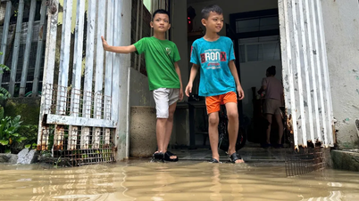
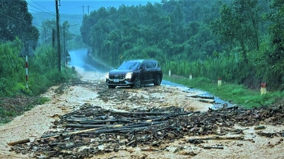
On the afternoon of September 28, Mr. Briu Quan, Chairman of the People's Committee of A Vuong commune, said that he had just led a working delegation of the commune to inspect the scene; visit and encourage 12 people of A'ur village who were staying in the commune center because the road to the village was cut off, water rose, and fallen trees were dangerous.

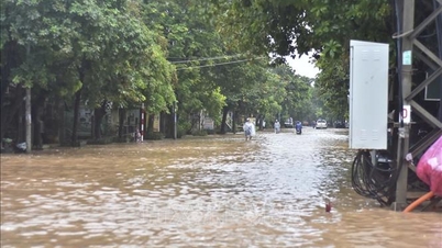
According to Mr. Briu Quan, in the morning of the same day, due to the influence of storm No. 10, the commune had moderate to heavy rain, the rainfall updated at 10:00 reached 80mm. The water level of rivers and streams such as: M'roong, Talang, Avuong, Ta'e... is rising from 1 - 1.5m compared to the average level.

Faced with the above situation, the leaders of A Vuong commune proactively directed 5 schools in the area to let students stay home on September 29 and monitor the storm situation to organize appropriate teaching and learning.
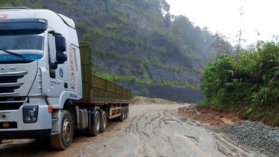
The power in the commune was cut off from 5:30 a.m. on September 28 until noon of the same day and has not been restored yet. Currently, the commune still has about 15 hectares of ripe summer-autumn rice that has not been harvested yet, mainly in the foothills of the high fields.


The Commune People's Committee has implemented the "4 on-the-spot" policy, ensuring food reserves, directing villages to reinforce houses, clear sewers, and prune trees with the participation of shock forces and on-site armed forces.
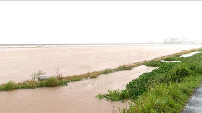
The locality has identified two main groups of threats: flash floods and inundation in the villages of Ta Lang, R'cung, Azut, Arec, A'ur, T'ghêy, Cr'toonh, Xa'oi; and landslide risks in the villages of Ateép, Bhloóc, Ga'lau, T'ghêy, Xa'oi, and L'gom.


The Commune Command has assigned forces to take charge of vulnerable areas, organized village meetings, and developed response plans, prioritizing inter-house evacuation in case of bad situations.
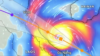
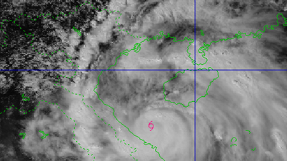
At noon of the same day, the Central Hydrometeorological Station issued an emergency bulletin about storm number 10.
At 10:00, the storm center was at about 17.0 degrees North latitude, 108.9 degrees East longitude, in the Quang Tri - Da Nang sea area, about 140km East Northeast of Hue City. The strongest wind near the storm center reached level 12 (118-133km/h), gusting to level 15, moving quickly in the West Northwest direction at a speed of about 25km/h.
The storm's impact caused strong winds of level 6, gusting to level 8 at many coastal stations from Quang Tri to Da Nang. Bach Long Vi Island alone recorded strong winds of level 7, gusting to level 9.
In the next 24 hours, the storm is expected to continue moving inland from Thanh Hoa to Northern Quang Tri provinces, then gradually weaken into a tropical depression and then into a low pressure area in the Upper Laos region.
Source: https://www.sggp.org.vn/mua-lon-chia-cat-nhieu-noi-o-xa-bien-gioi-a-vuong-da-nang-post815197.html

![[Photo] National Assembly Chairman Tran Thanh Man attends the inauguration ceremony of the Memorial Site of National Assembly Standing Committee Chairman Bui Bang Doan](https://vphoto.vietnam.vn/thumb/1200x675/vietnam/resource/IMAGE/2025/9/28/6feba23492d14b03b05445dd9f1dba88)


Comment (0)