
Today (October 9), in the area from South Quang Tri to Hue city and the South Central Coast, there was rain, moderate rain and scattered thunderstorms, locally heavy to very heavy rain in some places. The rainfall from 7am to 3pm on October 9 was over 60mm in some places such as: Phong Dien Town station (Hue) 102.4mm, Nui Thanh station ( Da Nang ) 74.6mm, Cua Viet station (Quang Tri) 64mm...
Floods on Cau River (Thai Nguyen) at Gia Bay station, Trung River (Lang Son) at Huu Lung station are receding. Floods on Cau River ( Bac Ninh ) are rising slowly. Floods on Thuong River (Bac Ninh) have peaked at 7.60m (at 3am on October 9), 1.30m above the historical flood level in 1986 and are receding.
Forecast for the evening and night of October 9, the area from South Quang Tri to Hue, the coastal area of South Central and Southern Vietnam will have rain, moderate rain and scattered thunderstorms with rainfall from 10-40mm, locally heavy rain to very heavy rain over 80mm. The Central Highlands area will have showers and scattered thunderstorms with rainfall from 10-30mm, locally heavy rain over 60mm. Warning of the risk of heavy rain (over 60mm/3 hours).
Thunderstorms may produce tornadoes, lightning, hail, and strong gusts of wind. Localized heavy rain may cause flash floods in small rivers and streams, landslides on steep slopes, and inundation in low-lying areas.
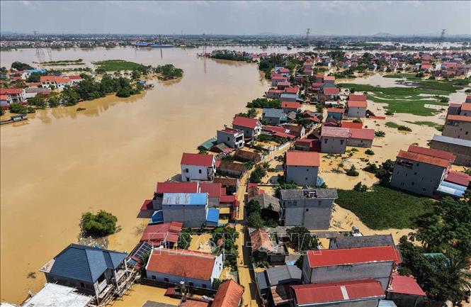
Exceptionally large floods on Cau River and Thuong River
Water levels at 1:00 p.m. on October 9 on the rivers were as follows: On the Cau River at Gia Bay station 26.53m, 0.47m below alert level 3, at Dap Cau station 7.40m, 1.10m above alert level 3; on the Thuong River at Cau Son station 18.22m, 2.22m above alert level 3; at Phu Lang Thuong station 7.57m, 1.27m above alert level 3, 0.05m above the historical flood of 1986 (7.52m). On the Trung River at Huu Lung station 23.04m, 0.5m above the historical level of 1986 (22.54m).
It is forecasted that in the next 12 hours, the flood on Cau River is likely to peak, the flood peak at Dap Cau station will be about 1.3m above alert level 3; the flood on Thuong River at Phu Lang Thuong station, on Trung River at Huu Lung station will decrease and be above alert level 3; the flood on Cau River at Gia Bay station will continue to decrease to alert level 1.
In the next 12-24 hours, floods on rivers will continue to decrease, water level on Cau River at Gia Bay station is below alarm level 1, at Dap Cau station is above alarm level 3; flood on Thuong River at Cau Son station, Phu Lang Thuong station, on Trung River at Huu Lung station is above alarm level 3.
Warning: In the next 24 hours, flood on Luc Nam River (Bac Ninh) at Luc Nam station, flood on Thai Binh River (Hai Phong) at Pha Lai station will fluctuate above alert level 1.
Widespread flooding in Thai Nguyen, Bac Ninh, Lang Son provinces in the next 2-3 days and risk of flooding in low-lying areas along rivers, urban areas in the Northern region; risk of landslides on river banks, river dykes and landslides on slopes in mountainous areas of the Northern region. Flood risk warning level: Level 3.
Thunderstorms and strong winds at sea

Currently, the low pressure trough has an axis at about 12-14 degrees North latitude connecting with a low pressure area located at 13:00 at about 13.5 - 14.5 degrees North; 114.5 - 115.5 degrees East. The Central and Southern East Sea (including Truong Sa special zone), the sea area from South Quang Tri to Ca Mau, Ca Mau to An Giang and the Gulf of Thailand are experiencing showers and thunderstorms.
It is forecasted that from the night of October 9 and October 10, the Central and Southern East Sea (including Truong Sa special zone), the sea area from South Quang Tri to Ca Mau, Ca Mau to An Giang and the Gulf of Thailand will have showers and thunderstorms. During the thunderstorms, there is a possibility of tornadoes, strong gusts of wind of level 6-7 and waves over 2m high.
All vessels operating in the above areas are at risk of being affected by tornadoes and strong gusts of wind.
Specific weather in each region on the night of October 9 and October 10
In the Northwest region, there will be rain in some places at night, sunny and light wind during the day. The lowest temperature will be from 22-25 degrees Celsius, in some places below 21 degrees Celsius; the highest temperature will be from 30-33 degrees Celsius, in some places above 33 degrees Celsius.
In the Northeast, the sky is cloudy, with rain at night in some places, sunny during the day, light wind. The lowest temperature is from 22-25 degrees Celsius, in mountainous areas it is below 22 degrees Celsius; the highest temperature ranges from 30-33 degrees Celsius, in some places it is above 33 degrees Celsius.
The area from Thanh Hoa to Hue has a clear differentiation. The North (Thanh Hoa to Quang Binh) is cloudy, with scattered showers at night and sunny days; meanwhile, the South (Quang Tri to Hue) is cloudy, with rain, moderate rain and scattered thunderstorms, with some places having heavy to very heavy rain. The Northeast to East wind is level 2-3. During thunderstorms, there is a possibility of tornadoes, lightning and strong gusts of wind. The lowest temperature in the whole area is from 23-26 degrees Celsius; the highest temperature in the North is 30-33 degrees Celsius, in the South is 27-30 degrees Celsius.
The South Central Coast has rain, moderate rain and scattered thunderstorms, locally heavy to very heavy rain. Northeast to East wind level 2-3 in the North, light wind in the South. During thunderstorms, beware of tornadoes, lightning and strong gusts of wind. Lowest temperature from 23-26 degrees Celsius, highest from 27-30 degrees Celsius.
The Central Highlands is cloudy with scattered showers and thunderstorms; in the afternoon and at night there will be scattered showers and thunderstorms, with some heavy rain. During thunderstorms, tornadoes, lightning, and strong gusts of wind may occur. The lowest temperature is 19–22 degrees Celsius and the highest is 26–29 degrees Celsius.
In Hanoi, there is no rain at night, sunny days, light winds. The lowest temperature is commonly from 24-26 degrees Celsius, the highest ranges from 31-33 degrees Celsius.
In the Southern region, including Ho Chi Minh City, it will be cloudy with rain, moderate rain and scattered thunderstorms; locally heavy to very heavy rain, concentrated in the afternoon and at night. West to Southwest wind level 2-3. During thunderstorms, there is a risk of tornadoes, lightning and strong gusts of wind. The lowest temperature is from 23-26 degrees Celsius; the highest temperature ranges from 29-32 degrees Celsius, with the highest temperature in Ho Chi Minh City being around 30-32 degrees Celsius.
Source: https://baotintuc.vn/van-de-quan-tam/thoi-weather-dem-9-va-ngay-1010-nhieu-khu-vuc-co-mua-lu-tren-song-cau-tiep-tuc-len-20251009175828300.htm
![[Photo] Prime Minister Pham Minh Chinh chairs a meeting of the Government Standing Committee on overcoming the consequences of natural disasters after storm No. 11](https://vphoto.vietnam.vn/thumb/1200x675/vietnam/resource/IMAGE/2025/10/09/1759997894015_dsc-0591-jpg.webp)
![[Photo] President Luong Cuong attends the 80th Anniversary of the Traditional Day of Vietnamese Lawyers](https://vphoto.vietnam.vn/thumb/1200x675/vietnam/resource/IMAGE/2025/10/09/1760026998213_ndo_br_1-jpg.webp)
![[Photo] General Secretary To Lam visits Kieng Sang Kindergarten and the classroom named after Uncle Ho](https://vphoto.vietnam.vn/thumb/1200x675/vietnam/resource/IMAGE/2025/10/09/1760023999336_vna-potal-tong-bi-thu-to-lam-tham-truong-mau-giao-kieng-sang-va-lop-hoc-mang-ten-bac-ho-8328675-277-jpg.webp)


Comment (0)