
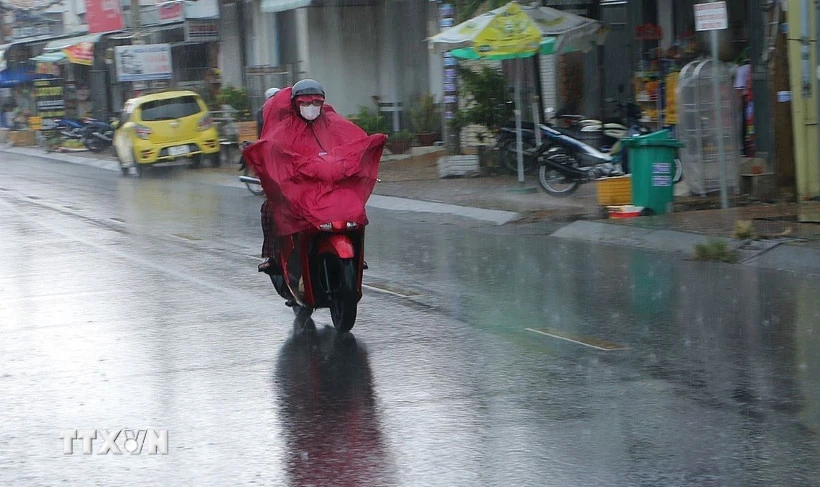
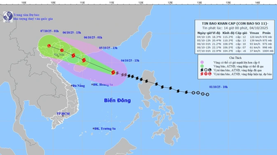
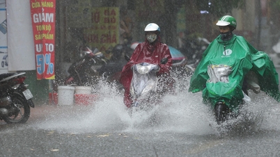
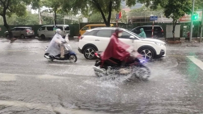
According to the National Center for Hydro-Meteorological Forecasting, during the day and night of September 13, many areas will have thunderstorms, with the possibility of tornadoes, lightning, hail and strong gusts of wind.
Localized heavy rain appears in some places. At sea, there is a possibility of strong gusts of wind, tornadoes, and high waves.
Many areas of heavy rain
The National Center for Hydro-Meteorological Forecasting forecasts that on the day and night of September 13, the mountainous areas of the North and the provinces from Quang Ngai to Lam Dong will have scattered showers and thunderstorms of 10-30mm, with localized heavy to very heavy rain of over 100mm.
In the afternoon and night of September 13, the Southern region will have scattered showers and thunderstorms of 10-30mm, with some places experiencing heavy rain of over 80mm. Warning of the risk of heavy rain of over 80mm in 3 hours.
"Thunderstorms are likely to cause tornadoes, lightning, hail and strong gusts of wind. Localized heavy rains can cause flash floods on small rivers and streams, landslides on steep slopes and flooding in low-lying areas," noted Deputy Head of the Weather Forecasting Department Le Thi Loan.
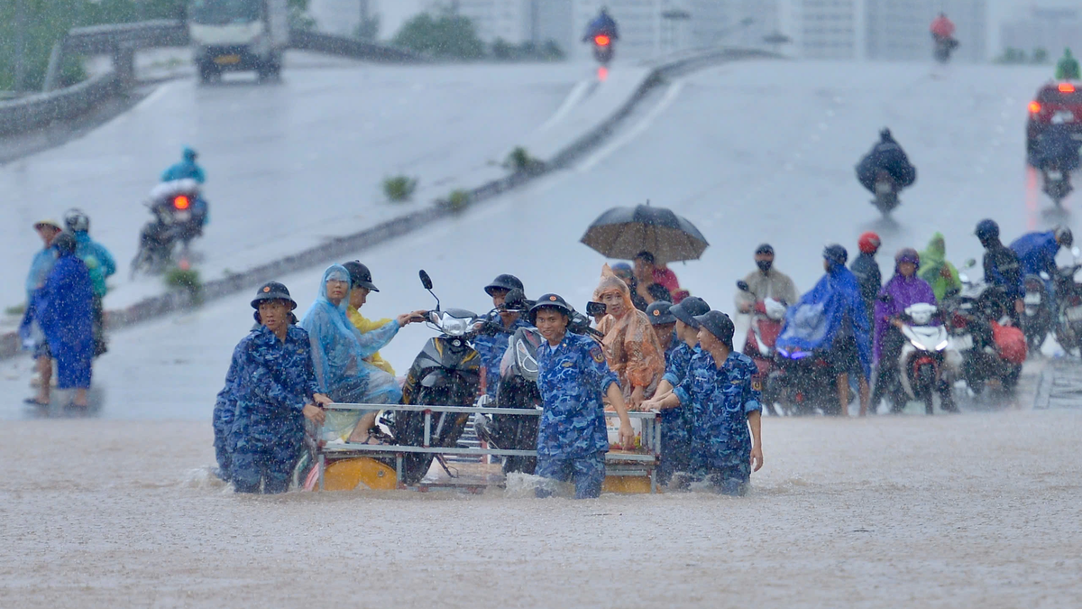
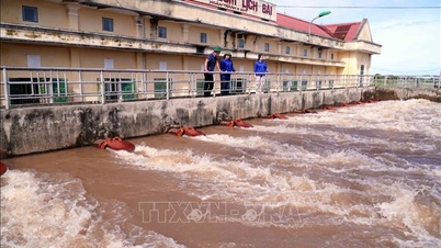
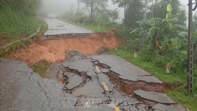
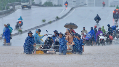
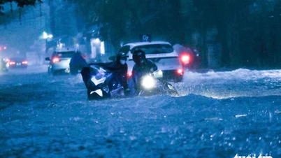
Flash floods and landslides can have serious impacts on the environment, threaten people's lives, cause local traffic congestion, disrupt vehicle circulation, destroy civil works, and cause great damage to production and socio -economic life.
Local authorities need to review flow bottlenecks and vulnerable locations to promptly take preventive measures and minimize damage.
According to the guidance of the Department of Dyke Management and Natural Disaster Prevention and Control ( Ministry of Agriculture and Environment ), affected localities need to closely monitor developments of heavy rain, floods, inundation, flash floods, and landslides. Information needs to be communicated promptly and fully to the authorities and people for proactive response.
Localities need to deploy shock troops to inspect and review residential areas along rivers, streams, and low-lying areas to proactively relocate and evacuate people from areas at high risk of deep flooding, flash floods, and landslides. At the same time, it is necessary to arrange traffic control forces and put up warning signs in dangerous areas such as overflow tunnels, deeply flooded roads, and fast-flowing water.
In addition, it is necessary to proactively prepare materials, vehicles and human resources to fix problems and ensure smooth traffic, especially on major routes in case of prolonged heavy rain.
On the night of September 12 and early morning of September 13, the mountainous areas of the North had scattered showers and thunderstorms, with some areas experiencing heavy to very heavy rain. The rainfall from 7:00 p.m. on September 12 to 3:00 a.m. on September 13 was over 90mm in some places, such as: Chieng Khuong 1 (Son La) 104.4mm, Khanh Hoa 2 (Lao Cai) 97.4mm, Tan Lap 1 (Tuyen Quang) 226.2mm...
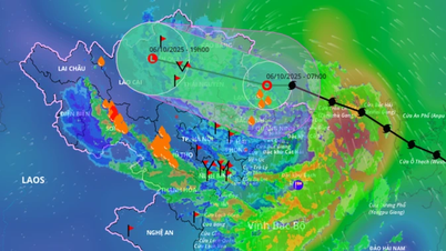
Many sea areas have strong gusts of wind and high waves.
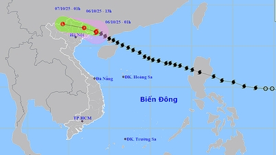
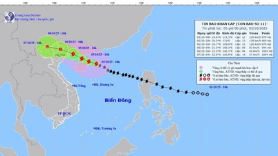
The National Center for Hydro-Meteorological Forecasting said that the sea area from Gia Lai to Lam Dong, the Gulf of Thailand, and the central and southern East Sea will have scattered showers and thunderstorms.
Forecast for the day and night of September 13, the sea area from Gia Lai to Ca Mau, Ca Mau to An Giang, the Gulf of Thailand, the central and southern East Sea (including Truong Sa special zone) will have scattered showers and thunderstorms, with the possibility of tornadoes, strong gusts of wind of level 6-7 and waves over 2m high.
All vessels operating in the above areas are at risk of being affected by tornadoes and strong gusts of wind.
According to the guidance of the Ministry of Agriculture and Environment, to ensure the safety of people and vehicles operating at sea, localities must closely monitor warning and forecast bulletins; promptly notify captains, owners of vehicles and vessels operating at sea to proactively prevent and adjust production plans accordingly, ensuring the safety of people and property; and maintain communication to promptly handle bad situations that may occur.
Weather in regions day and night September 13
The Northwest region has scattered showers and thunderstorms, locally heavy to very heavy rain, with the possibility of tornadoes, lightning, hail and strong gusts of wind. The lowest temperature is 24-27 degrees Celsius, in some places below 23 degrees Celsius. The highest temperature is 30-33 degrees Celsius, in some places above 34 degrees Celsius.
In the Northeast, there will be scattered showers and thunderstorms; in mountainous areas, there will be scattered showers and thunderstorms, with some places experiencing heavy to very heavy rain. During thunderstorms, there is a possibility of tornadoes, lightning, hail, and strong gusts of wind. The lowest temperature is 25-28 degrees Celsius. The highest temperature is 31-34 degrees Celsius, with some places above 34 degrees Celsius.
Hanoi city has sunny days, showers and thunderstorms in the late afternoon and at night in some places, with the possibility of tornadoes, lightning and strong gusts of wind. Southeast wind level 2-3. Lowest temperature 26-28 degrees Celsius. Highest temperature 32-34 degrees Celsius, some places above 34 degrees Celsius.
Provinces and cities from Thanh Hoa to Hue: sunny during the day, scattered showers and thunderstorms in the late afternoon and at night, with the possibility of tornadoes, lightning and strong gusts of wind. Lowest temperature 25-28 degrees Celsius. Highest temperature 31-34 degrees Celsius, some places over 34 degrees Celsius.
The South Central Coast has scattered showers and thunderstorms, locally heavy rain, with the possibility of tornadoes, lightning, hail and strong gusts of wind. Lowest temperature 24-27 degrees Celsius. Highest temperature 30-33 degrees Celsius.
The Central Highlands has scattered showers and thunderstorms, locally heavy to very heavy rain, with the possibility of tornadoes, lightning, hail and strong gusts of wind. The lowest temperature is 20-23 degrees Celsius. The highest temperature is 28-31 degrees Celsius, some places above 31 degrees Celsius.
The Southern region has scattered showers and thunderstorms, some places have heavy rain, in thunderstorms there is a possibility of tornadoes, lightning, hail and strong gusts of wind. Lowest temperature 23-26 degrees Celsius. Highest temperature 29-32 degrees Celsius, some places above 32 degrees Celsius.
Ho Chi Minh City has scattered showers and thunderstorms, locally heavy rain, with the possibility of tornadoes, lightning, hail and strong gusts of wind. Lowest temperature 24-26 degrees Celsius. Highest temperature 30-32 degrees Celsius.
Source: VNA
Source: https://baophutho.vn/thoi-tiet-ngay-13-9-bac-bo-cuc-bo-co-mua-to-co-noi-luong-mua-tren-100mm-239552.htm

![[Photo] Prime Minister Pham Minh Chinh chaired a meeting of the Steering Committee on the arrangement of public service units under ministries, branches and localities.](https://vphoto.vietnam.vn/thumb/1200x675/vietnam/resource/IMAGE/2025/10/06/1759767137532_dsc-8743-jpg.webp)

![[Photo] Prime Minister Pham Minh Chinh chairs a meeting of the Government Standing Committee to remove obstacles for projects.](https://vphoto.vietnam.vn/thumb/1200x675/vietnam/resource/IMAGE/2025/10/06/1759768638313_dsc-9023-jpg.webp)


Comment (0)