
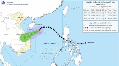
It is forecasted that in the next 24 hours, the storm will move in the West-Southwest direction at a speed of 10-15 km/hour, and at 4:00 a.m. on October 22, it will be in the Northwest of Hoang Sa sea area, maintaining a level 9-10 intensity, gusting to level 12.
By the morning of October 23, the storm tended to move southwest, approaching the sea area from Thua Thien Hue to Quang Ngai , gradually weakening into a tropical depression with strong winds of level 6, gusts of level 8. It is expected that by October 24, the storm circulation will move deep into southern Laos and weaken into a low pressure area.
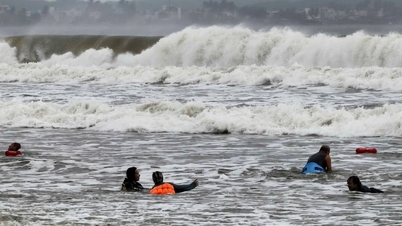
In the East Sea, the North East Sea area, including the Hoang Sa sea area, has strong winds of level 7-8, near the storm center level 9-11, gusts of level 13; waves 3-5 m high, near the storm center 5-7 m, rough seas. The area from South Quang Tri to Quang Ngai (including Ly Son island) has strong winds of level 6, from the morning of October 22 increasing to level 7, near the storm center level 8, gusts of level 10; waves 3-5 m high, rough seas. Ships operating in the dangerous area may be affected by thunderstorms, tornadoes, strong winds and big waves, and should absolutely avoid the storm center area.
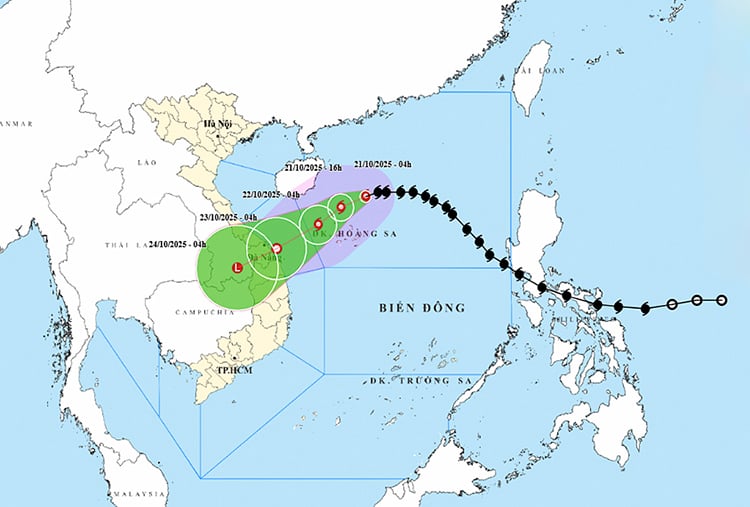
On land, from the night of October 22-26, due to the influence of storm circulation combined with cold air and high-altitude easterly winds, the area from Ha Tinh to Quang Ngai will have heavy to very heavy rain. Rainfall is generally 200-400 mm, locally over 500 mm; in particular, the area from South Quang Tri to Da Nang will have exceptionally heavy rain of 500-700 mm, over 900 mm in some places. Heavy rain will last until the end of October, causing a high risk of flash floods and landslides in mountainous areas, and flooding in low-lying areas and coastal cities.
Currently, cold air has weakly affected the North Central region and some places in the Northwest. At Bach Long Vy station, strong Northeast wind level 6, sometimes level 7, gusting to level 8; at Con Co station, wind level 6. It is forecasted that during the day and night of October 21, cold air will continue to spread to the Central Central region, making the weather in the North and Thanh Hoa cold at night and morning, and cold in the mountains. The lowest temperature is commonly 19-21 degrees Celsius, in the midlands and mountains 17-19 degrees Celsius, in the high mountains below 16 degrees Celsius.
In Hanoi, the weather is stable, no rain at night, sunny during the day, cold at night and early morning, temperature around 19-21 degrees Celsius.
The meteorological agency recommends that localities directly affected by the storm proactively develop plans to prevent and combat natural disasters, ensuring safety for boats, coastal structures and vulnerable residential areas.
Weather forecast for regions across the country:
Hanoi capital has few clouds, sunny days, no rain at night. Northeast wind level 3. Lowest temperature 20-22 degrees Celsius. Highest temperature 28-30 degrees Celsius.
The Northwestern provinces are cloudy, sunny during the day, no rain at night. Light wind. Cold in the morning and at night, some places are freezing. Lowest temperature 18-21 degrees Celsius, some places below 16 degrees Celsius. Highest temperature 28-31 degrees Celsius.
The Northeastern region has few clouds, sunny days and no rain at night. Northeast wind level 3, especially in coastal areas level 3-4. Cold mornings and nights, cold in mountainous areas. Lowest temperature 18-21 degrees Celsius, mountainous areas 17-19 degrees Celsius, high mountainous areas have places below 16 degrees Celsius. Highest temperature 27-30 degrees Celsius.
Provinces from Thanh Hoa to Hue: In the North, it is cloudy, no rain, sunny in the afternoon; in the South (from Ha Tinh - Hue City), there is rain, scattered showers and thunderstorms, locally heavy rain. Wind from the north to northwest level 3, coastal areas level 3-4. During thunderstorms, there is a possibility of tornadoes, lightning and strong gusts of wind. Lowest temperature 22-25 degrees Celsius. Highest temperature 28-31 degrees Celsius.
The South Central Coast region is cloudy, with scattered showers and thunderstorms in the North, with some heavy rain in some places; and scattered showers and thunderstorms in the South. Northeast wind level 2-3. During thunderstorms, there is a possibility of tornadoes, lightning, and strong gusts of wind. Lowest temperature 23-26 degrees Celsius. Highest temperature 28-31 degrees Celsius.
The Central Highlands is cloudy with scattered showers and thunderstorms, with scattered showers and thunderstorms in the afternoon and evening. Light winds. Thunderstorms may include tornadoes, lightning, hail, and strong gusts of wind. Lowest temperature 19-22 degrees Celsius. Highest temperature 27-30 degrees Celsius.
The South is cloudy with scattered showers and thunderstorms, with scattered showers and thunderstorms in the afternoon and evening, and some places with heavy rain. Light wind. Thunderstorms may cause tornadoes, lightning, hail, and strong gusts of wind. Lowest temperature 23-26 degrees Celsius. Highest temperature 31-34 degrees Celsius.
Ho Chi Minh City is cloudy with scattered showers and thunderstorms, with scattered showers and thunderstorms in the afternoon and evening, and some places with heavy rain. Light wind. During thunderstorms, there is a possibility of tornadoes, lightning, hail, and strong gusts of wind. Lowest temperature 24-26 degrees Celsius. Highest temperature 32-34 degrees Celsius.
Source: https://baotintuc.vn/xa-hoi/thoi-tiet-ngay-2110-bao-so-12-manh-cap-10-huong-vao-mien-trung-20251021055933075.htm
![[Photo] Prime Minister Pham Minh Chinh meets with Speaker of the Hungarian National Assembly Kover Laszlo](https://vphoto.vietnam.vn/thumb/1200x675/vietnam/resource/IMAGE/2025/10/20/1760970413415_dsc-8111-jpg.webp)


![[Photo] Prime Minister Pham Minh Chinh received Mr. Yamamoto Ichita, Governor of Gunma Province (Japan)](https://vphoto.vietnam.vn/thumb/1200x675/vietnam/resource/IMAGE/2025/10/21/1761032833411_dsc-8867-jpg.webp)
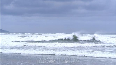
![[Photo] Da Nang residents "hunt for photos" of big waves at the mouth of the Han River](https://vphoto.vietnam.vn/thumb/1200x675/vietnam/resource/IMAGE/2025/10/21/1761043632309_ndo_br_11-jpg.webp)


Comment (0)