
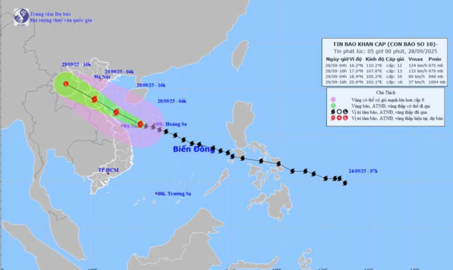
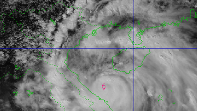
At 4:00 a.m. on September 28 , the center of the storm was located at about 16.2 degrees North latitude; 110.2 degrees East longitude, in the sea west of Hoang Sa special zone, about 200km east of Da Nang city. The strongest wind near the center of the storm was level 12 (118-133km/h), gusting to level 15. Moving in the West Northwest direction at a speed of 30km/h. This is a very fast moving storm (nearly twice the average speed), with strong storm intensity, wide area of influence, and can cause combined impacts of many types of natural disasters such as strong winds, heavy rains, floods, flash floods, landslides and coastal flooding.
Storm development forecast ( in the next 24 to 48 hours ) :
| Forecast time | Direction , speed | Location | Intensity | Danger zone | Disaster Risk Level ( Affected Area ) |
| 4:00 p.m. September 28 | West Northwest, about 30km/h, likely to strengthen | 17.5-107.6E, on the sea of Nghe An-Quang Tri | Level 12-13, level 16 | Latitude 14.0N- 20.0N; West of longitude 113.0E | Level 3 : the western sea area of the North and Central East Sea (including Hoang Sa special zone ) ; the sea area from Thanh Hoa to Quang Ngai |
| 4:00 a.m. September 29 | West Northwest, about 25-30km/h, going inland to the Central provinces | 18.9N- 105.2E, on the mainland of provinces from Thanh Hoa to Ha Tinh | Level 9-10, jerk level 13 | Latitude 15.0N- 20.0N; West of longitude 112.0E | Level 4 : coastal mainland areas from Nghe An to the north of Quang Tri Level 3 : the western sea area of the North and Central East Sea (including Hoang Sa special zone ) ; the sea area from Thanh Hoa to Quang Ngai |
| 4:00 p.m. September 29 | West Northwest, 20-25km/h, moving inland and weakening into a tropical depression, then a low pressure area | 20.6N- 102.0E, in the Upper Laos area | < Level 6 | North of latitude 16.0N; West of longitude 106.5E | Level 3 : from Thanh Hoa to Quang Tri (including Hon Ngu Island) and Northern Gulf of Tonkin (including Bach Long Vy, Van Don, Co To, Cat Hai and Hon Dau Island special zones); Mainland area from Ninh Binh to Quang Tri |
Storm warning:
- The North and Central East Sea (including Hoang Sa special zone) has strong winds of level 8-9, the area near the storm's eye has winds of level 10-13, gusts of level 16, waves from 6.0-8.0m high, the area near the storm's eye has waves of 8.0-10.0m, and the sea is very rough.
- In the sea area of Nghe An (including Hon Ngu island), the wind gradually increased to level 6-7, gusting to level 8-9, waves 3.0 - 5.0m high, rough seas. From early morning on September 28, the wind increased to level 8-9, the area near the storm center passed level 10-13 , gusting to level 16 , waves 5.0 - 7.0m high , rough seas ( extremely large destructive force , extremely strong waves . Sinking large ships ) .
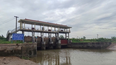
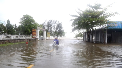
Storm surge in coastal areas : Nghe An coastal areas have storm surges of 1.5-2.0m high. There is a high risk of flooding of dykes, coastal roads, and river mouths due to rising sea levels and very high storm waves on the evening and night of September 28.
Warning : The weather at sea and in coastal areas during the storm is extremely dangerous and unsafe for any vehicle or structure operating in the danger zone such as: cruise ships, passenger ships, transport ships, cages, rafts, aquaculture areas, dykes, embankments, coastal routes. Vehicles are at high risk of capsize, destruction, and flooding due to strong winds, big waves, and rising sea levels.
On land :
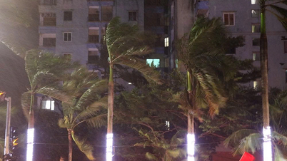
From the afternoon of September 28, on the mainland in Nghe An province, the wind gradually increased to level 6-7 , then increased to level 8-9, the area near the storm center passed level 10-12 ( wind force can knock down trees , houses , electric poles , causing very heavy damage ) , gust level 14 .
From September 28 to September 30, Nghe An province will have heavy to very heavy rain and thunderstorms. Forecasted rainfall: in the coastal plains and midlands: 150 - 300mm, some places over 450mm such as Hoang Mai, Truong Vinh, Nam Dan...; Mountainous areas: 150 - 250mm, some places over 350mm such as Que Phong, Quy Chau... Warning of risk of heavy rain (100mm/3h).
Thunderstorms may include tornadoes, lightning, hail and strong gusts of wind.
Source: https://baonghean.vn/tin-moi-nhat-ve-bao-so-10-tu-ngay-28-9-den-30-9-tinh-nghe-an-co-mua-to-den-rat-to-va-dong-10307226.html

![[Photo] High-ranking delegation of the Russian State Duma visits President Ho Chi Minh's Mausoleum](https://vphoto.vietnam.vn/thumb/1200x675/vietnam/resource/IMAGE/2025/9/28/c6dfd505d79b460a93752e48882e8f7e)

![[Photo] The 4th meeting of the Inter-Parliamentary Cooperation Committee between the National Assembly of Vietnam and the State Duma of Russia](https://vphoto.vietnam.vn/thumb/1200x675/vietnam/resource/IMAGE/2025/9/28/9f9e84a38675449aa9c08b391e153183)
![[Photo] National Assembly Chairman Tran Thanh Man presided over the welcoming ceremony for Chairman of the State Duma of the Russian Federation Vyacheslav Volodin](https://vphoto.vietnam.vn/thumb/1200x675/vietnam/resource/IMAGE/2025/9/28/889b54ac5cd440099ddc618c99663612)
![[Photo] Joy on the new Phong Chau bridge](https://vphoto.vietnam.vn/thumb/1200x675/vietnam/resource/IMAGE/2025/9/28/b00322b29c8043fbb8b6844fdd6c78ea)


Comment (0)