
Mr. Hoang Phuc Lam, Deputy Director of the National Center for Hydro-Meteorological Forecasting, predicted that in the early morning of October 6, storm Matmo could make landfall in Quang Ninh with an intensity of level 9-10.
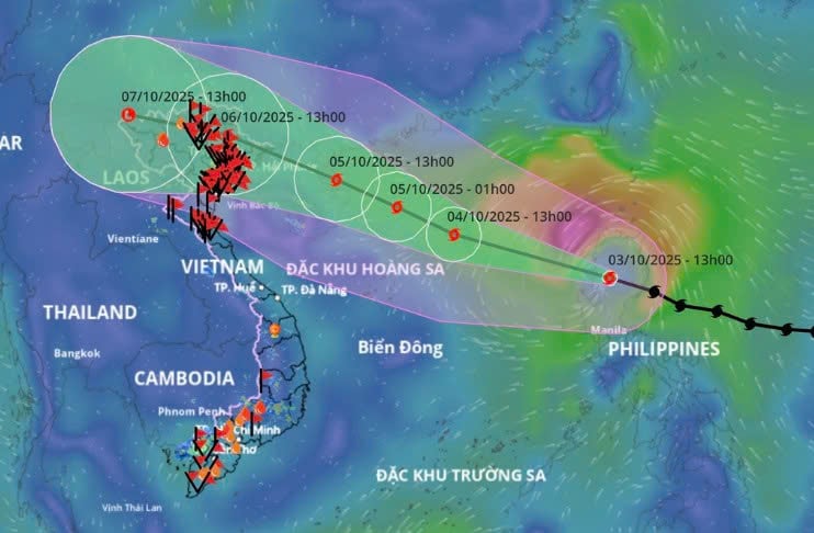
On the afternoon of October 3, Mr. Hoang Phuc Lam said that storm Matmo had entered the East Sea, the 11th storm this year.
At 5:00 p.m., the storm center was in the eastern sea of the North East Sea. The strongest wind near the storm center was level 10 (89-102 km/h), gusting to level 13. The storm moved west-northwest at a speed of about 25 km/h.
He assessed that, along with storm Bualoi (storm number 10), storm Matmo also has a very fast moving speed compared to the average speed of other storms in the East Sea and the Northwest Pacific .
It is forecasted that when entering the eastern sea of the East Sea, the storm will continuously increase in intensity, moving rapidly at a speed of 20-25km/h.
On the evening of October 4, storm No. 11 is forecast to reach its maximum intensity of level 12-13, gusting to level 14-15, in the East of Leizhou Peninsula (China).
According to Mr. Lam, after entering the sea of Guangdong province (China), there will be two scenarios for the movement of storm No. 11.
Scenario one (probability about 70-75%), storm Matmo will move northward, move more over land, and when reaching the northern area of Quang Ninh province, it will weaken by 2-4 levels compared to the time when the storm is at its strongest.
With this scenario, the Gulf of Tonkin area has strong winds of level 9-10.
Scenario two (probability about 25-30%): The subtropical high pressure weakens slightly, causing the storm to move mainly over the sea, weakening less. The storm's intensity when entering the Quang Ninh area will be stronger, possibly causing strong winds of level 9-10 (gusts of level 12-14).
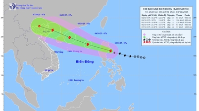
 |
| Direction of movement of storm Matmo (Photo: Vietnam Disaster Monitoring System). |
Regardless of the scenario, storm Matmo is forecast to make landfall in Quang Ninh; landfall time is early morning October 6.
However, Mr. Hoang Phuc Lam warned that since 7:00 p.m. on October 5, the coastal area of Quang Ninh has been affected by strong winds and heavy rain.
Due to the influence of storm No. 11, the Northern region, Thanh Hoa - Nghe An provinces have heavy rain, the rain lasts from the night of October 5 to the end of the night of October 7, the common rainfall is 100-200mm, in some places over 300mm.
"The focus of the rain is the mountainous and midland areas of the North, with rainfall ranging from 150-250mm, and locally over 400mm. With heavy rainfall, we warn of a prolonged flood from October 6 to 9 on rivers in the North, Thanh Hoa - Nghe An," Mr. Hoang Phuc Lam forecasted.
He added that the circulation of storm Matmo will also cause heavy rain in Hanoi with common rainfall of 100-200mm, the rain will concentrate in the early morning of October 6, and last until the next morning of October 7.
Recently in the North, Thanh Hoa - Nghe An provinces have had prolonged heavy rain due to the influence of storm No. 10, so Mr. Hoang Phuc Lam especially warned these localities to be on guard against landslides, flash floods, and flash floods in the coming days.
Explaining the reason why consecutive storms appeared in late September and early October this year affecting our country, he said it could be due to the influence of the Enso phenomenon which is currently in its neutral phase.
"In neutral phases, storms tend to form more frequently, moving more to the West of the Northwest Pacific region (the Eastern part of the Philippines and the East Sea). In neutral years, Vietnam or Southeast Asian countries will have more storms," said Mr. Lam.
The Enso phenomenon (El Niño - Southern Oscillation) is a recurring climate pattern, consisting of three states: El Niño (warming of ocean waters), La Niña (colding of ocean waters) and neutral state, related to temperature changes in the central and eastern tropical Pacific Ocean, changes in atmospheric circulation. |
According to dantri.com.vn
Source: https://baovinhlong.com.vn/thoi-su/202510/bao-matmo-vao-bien-dong-du-bao-do-bo-quang-ninh-b7936cf/
![[Photo] Students of Binh Minh Primary School enjoy the full moon festival, receiving the joys of childhood](https://vphoto.vietnam.vn/thumb/1200x675/vietnam/resource/IMAGE/2025/10/3/8cf8abef22fe4471be400a818912cb85)


![[Photo] Prime Minister Pham Minh Chinh chairs meeting to deploy overcoming consequences of storm No. 10](https://vphoto.vietnam.vn/thumb/1200x675/vietnam/resource/IMAGE/2025/10/3/544f420dcc844463898fcbef46247d16)


Comment (0)