
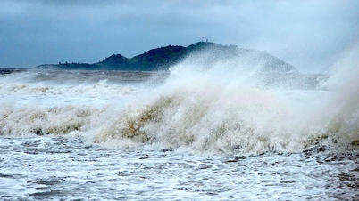
Quang Ngai Hydrometeorological Station has just issued an emergency storm bulletin about storm No. 10, warning that this is a strong storm with a wide range of influence, moving at a very fast speed (nearly twice the average speed). The storm is capable of causing a combination of many types of natural disasters such as strong winds, heavy rains, floods, flash floods, landslides and coastal flooding.
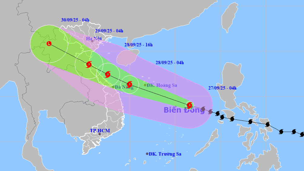
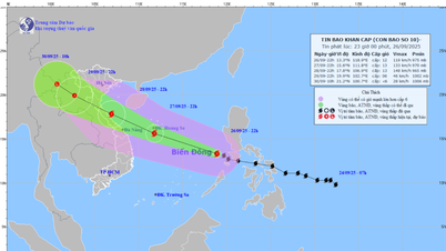
At 4:00 a.m. on September 27, the eye of the storm was at about 14 degrees north latitude; 116.6 degrees east longitude, about 580 km east-southeast of Hoang Sa special zone. The strongest wind near the eye of the storm was level 11 - 12 (103 - 133 km/h), gusting to level 15. The storm was moving west-northwest at a very fast speed, about 35 - 40 km/h.
In the next 24 hours, the storm is forecast to continue moving rapidly in a west-northwest direction and maintain its strong intensity. At 4:00 a.m. on September 28, the storm will be located at 15.2 degrees north latitude; 111 degrees east longitude, with intensity still at level 12, gusting to level 15.
At 4:00 a.m. on September 29, the storm continued to move rapidly at a speed of 20 - 25 km/h, located at 16.8 degrees north latitude; 107.3 degrees east longitude, with intensity weakening to level 9, gusting to level 11.
The disaster risk level for the central and northern East Sea (including Hoang Sa special zone) is currently level 3, and for the coast from Quang Tri to Quang Ngai it is also level 3.
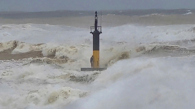
Due to the storm's influence, the sea off the coast of Quang Ngai province will have strong winds of level 5 from the morning of September 27. However, from noon to afternoon of September 27, the wind will strengthen to level 8, gusting to level 9 - 10, and from the night of September 27, it will continue to strengthen to level 8 - 9, gusting to level 10 - 11. Waves here will be 3 - 5m high, causing very rough seas.
The storm also caused heavy rain in Quang Ngai province from the morning of September 27 to the night of September 28. The coastal communes and wards are likely to have rainfall of 60 - 100mm, with some places reaching over 150mm.
The mountainous area west of Truong Son has rainfall from 30 - 70mm, some places over 90mm. People need to be on guard against the risk of landslides in high-risk mountainous areas, flooding of crops in low-lying areas, and flooding in urban areas due to localized heavy rain in a short period of time.
Source: https://quangngaitv.vn/bao-so-10-cap-12-giat-cap-15-dang-tien-nhanh-vao-bo-bien-mien-trung-6507846.html


![[Photo] National Assembly Chairman Tran Thanh Man attends the inauguration ceremony of the Memorial Site of National Assembly Standing Committee Chairman Bui Bang Doan](https://vphoto.vietnam.vn/thumb/1200x675/vietnam/resource/IMAGE/2025/9/28/6feba23492d14b03b05445dd9f1dba88)


Comment (0)