

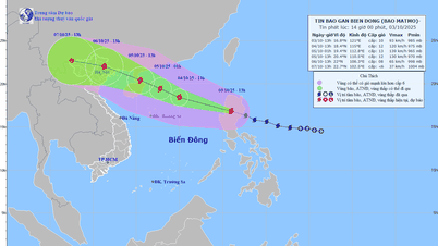
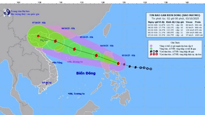
At 1 p.m. on August 24, the center of storm No. 5 was located at about 17.4 degrees North latitude - 110.3 degrees East longitude, in the sea northwest of Hoang Sa archipelago; about 520 km from Nghe An , 500 km from Ha Tinh and 430 km from northern Quang Tri. The strongest wind near the center of the storm was level 13 (134-149 km/h), gusting to level 15. The storm moved west at a speed of about 20 km/h and was likely to strengthen further.
It is forecasted that by 1:00 a.m. on August 25, the storm will be at 17.9 degrees North latitude - 108.3 degrees East longitude, in the southern Gulf of Tonkin, 260km from Nghe An, 230km from Ha Tinh, and 180km from northern Quang Tri . Winds are at level 13-14, gusting to level 16. Disaster risk is at level 3 for the western sea area of the northern East Sea, Gulf of Tonkin, and the sea from southern Quang Tri to Hue; level 4 for the coast of Thanh Hoa to Quang Tri.
At 1 p.m. on August 25, the storm center was at about 18.4 degrees North latitude - 106.0 degrees East longitude, right on the coast of the provinces from Thanh Hoa to Quang Tri. Strong winds of level 12-13, gusts of level 15. Natural disaster risk level 4 for the coast and mainland from Thanh Hoa to North Quang Tri. At 1 p.m. on August 26, the storm moved deep into mainland Central Laos, weakening below level 6, however the risk remained at level 4 on the mainland of Thanh Hoa - North Quang Tri and level 3 in the Gulf of Tonkin, sea from South Quang Tri to Hue.
At sea, the Northwestern part of the East Sea (including Hoang Sa archipelago) has strong winds of level 9-11, near the storm center level 12-14, gusts of level 16; waves 5-7m high, near the storm center 8-10m. The sea from Thanh Hoa to Hue has winds gradually increasing to level 10-11, near the storm center level 12-14, gusts of level 16; waves 5-7m high, near the storm center 8-10m. The North Gulf of Tonkin has winds of level 6-7, gusts of level 9; the South (Bach Long Vi area) has strong winds of level 8-9, gusts of level 11; waves 2.5-4.5m high. The sea and coastline are in an extremely dangerous state for boats, rafts and coastal structures.
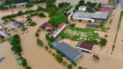
Storm surge from Hai Phong to Northern Quang Tri is likely to be 0.5-1.5m high. Water levels at Hon Dau are forecast to reach 3.3-3.8m, at Sam Son 3.2-3.7m, and at Hon Ngu 3.2-3.6m. There is a high risk of flooding in low-lying areas and river mouths, especially on the evening of August 25.
On land, from the night of August 24, coastal provinces from Thanh Hoa to Quang Tri will have strong winds of level 8-10, near the storm center of level 11-13, gusting to level 14-15. Areas from Quang Ninh to Ninh Binh will have winds of level 6-8, gusting to level 9.
Heavy rain will occur over a wide area. From August 24 to 26, the midlands and deltas of the North, Lao Cai, Thanh Hoa to Thua Thien Hue will have widespread rain of 100-150mm, with some places receiving over 250mm. The provinces from Thanh Hoa to Northern Quang Tri will have exceptionally heavy rain of 200-400mm, with some places receiving over 700mm. There is a risk of extremely heavy rain of over 200mm in just 3 hours. In Hanoi and Da Nang, there will be moderate to heavy rain, while in Ho Chi Minh City there will be local thunderstorms in the evening. From August 25 to 27, the Upper and Central Laos will have widespread rain of 100-250mm, with some places receiving over 500mm.
Source: https://baolaocai.vn/bao-so-5-giat-cap-15-ap-sat-bo-bien-thanh-hoa-quang-tri-post880376.html


![[Photo] General Secretary To Lam attends the 8th Congress of the Central Public Security Party Committee](https://vphoto.vietnam.vn/thumb/1200x675/vietnam/resource/IMAGE/2025/10/4/79fadf490f674dc483794f2d955f6045)
![[Infographic] Notable numbers after 3 months of "reorganizing the country"](https://vphoto.vietnam.vn/thumb/1200x675/vietnam/resource/IMAGE/2025/10/4/ce8bb72c722348e09e942d04f0dd9729)


![[Photo] Students of Binh Minh Primary School enjoy the full moon festival, receiving the joys of childhood](https://vphoto.vietnam.vn/thumb/1200x675/vietnam/resource/IMAGE/2025/10/3/8cf8abef22fe4471be400a818912cb85)
![[Photo] Prime Minister Pham Minh Chinh chairs meeting to deploy overcoming consequences of storm No. 10](https://vphoto.vietnam.vn/thumb/1200x675/vietnam/resource/IMAGE/2025/10/3/544f420dcc844463898fcbef46247d16)


Comment (0)