
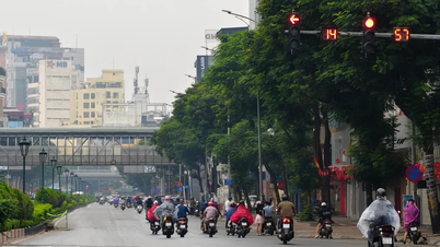
In October, 1-2 storms/tropical depressions may affect mainland Vietnam.
Commenting on weather patterns in October 2025, Deputy Head of Climate Forecasting Department, National Center for Hydro-Meteorological Forecasting Tran Thi Chuc said that in the East Sea, there is a possibility of 2-3 storms/tropical depressions appearing and 1-2 storms may affect the mainland of Vietnam (the average for many years in the East Sea is 2 storms, making landfall in Vietnam is 0.8 storms).
In the morning of October 1, the low pressure area in the sea east of Luzon Island (Philippines) strengthened into a tropical depression. At 1 p.m., the center of the tropical depression was at about 14.5 degrees North latitude; 130.9 degrees East longitude, in the sea east of Luzon Island (Philippines). The strongest wind near the center of the tropical depression was level 7 (50-61 km/h), gusting to level 9. Moving west at a speed of about 15 km/h.
At 1 p.m. on October 2, a tropical depression in the sea east of Luzon Island (Philippines) with strong winds of level 8, gusts of level 10, moving west-northwest at a speed of 15-20 km/h and likely to strengthen into a storm.
As of 1 p.m. on October 3, the storm was in the eastern part of Luzon Island (Philippines) with strong winds of level 9, gusts of level 11; moving west-northwest at a speed of about 20-25 km/h and likely to be stronger. The affected area is the eastern sea area of the North East Sea. Disaster risk level 3.
From the next 48 to 72 hours, the storm will move mainly in the West-Northwest direction, traveling 25-30 km per hour, entering the East Sea and continuing to strengthen.
Forecast of storm impact, from October 3, the sea area east of the North East Sea will have winds gradually increasing to level 6-7; near the storm center will be strong at level 8, gusting to level 10; waves 2.5 - 4.5m high, rough seas. Warning: During October 4 - 6, the North East Sea area (including Hoang Sa special zone) is likely to be affected by strong winds of level 10-11, gusting to level 14.
Vessels operating in the above mentioned dangerous areas are susceptible to the impact of storms, whirlwinds, strong winds and large waves.
To proactively respond to the tropical depression, the National Steering Committee for Civil Defense requested provinces and cities from Quang Ninh to Lam Dong to closely monitor warning bulletins, forecasts and developments of the tropical depression; notify captains and owners of vehicles and boats anchored at ports or operating at sea to proactively prevent and have appropriate production plans, ensuring safety of people and property; maintain communication to promptly handle bad situations that may occur.
Localities are ready with forces and means to deploy rescue work when there is a situation, and at the same time organize serious on-duty shifts and regularly report to the National Civil Defense Steering Committee ( Ministry of Agriculture and Environment ).
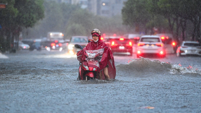
Regarding the rain situation, Ms. Chuc said that in October, there is a possibility of widespread heavy rains concentrated in the early period in the Northern region and Thanh Hoa; the provinces from Nghe An to the North of Khanh Hoa are likely to have some widespread heavy rains; other areas will have many days of showers and thunderstorms; in which, some days there may be moderate to heavy rain.
Ms. Tran Thi Chuc noted: "Cold air is likely to become stronger from mid-October 2025. Along with that, there is a continued possibility of dangerous weather phenomena such as thunderstorms, tornadoes, lightning, hail and strong gusts of wind across the country."
Along with that, the circulation after storm No. 10 is still likely to continue to strongly impact the weather, causing rain in many areas, emphasizing the areas of Son La, Phu Tho, Lao Cai, Tuyen Quang, Thai Nguyen, Cao Bang, Lang Son, Bac Ninh, Thanh Hoa, Nghe An with common accumulated rainfall from 20-50mm, in some places over 80mm.
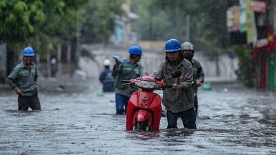
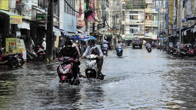
However, hydrometeorological experts emphasized that due to heavy rain in the past few days and the forecast of continued rain in the coming days, this shows that the soil moisture in the mountainous areas of North Central and the Northern midlands has become saturated (soaked with a lot of water). Therefore, the risk of flash floods and landslides in mountainous areas, hillsides, flash floods on rivers and streams in the above mentioned areas is very high. Thus, when storm No. 10 has passed and ended, the risk of flash floods and landslides due to heavy rain from the impact of storm No. 10's circulation still exists.
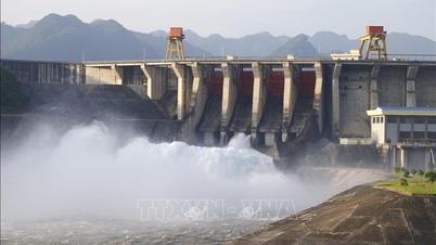
Hydrometeorological experts note: Flash floods and landslides will continue for the next 2-3 days. With heavy rainfall, many river systems may experience a flood and warnings are likely to rise to alert level 2 - alert level 3, with some rivers exceeding alert level 3. From the above high flood peak forecast, there is a risk of deep, widespread flooding in riverside areas, downstream areas, especially in the river areas in Ha Tinh, Nghe An, Thanh Hoa.
Regarding the weather in early October, the National Center for Hydro-Meteorological Forecasting said that from the night of October 2 to October 10, the Northern and North Central regions will have scattered showers and thunderstorms, and from October 6 to 8, there is a possibility of widespread heavy rain.
The area from Quang Tri to Hue city and the South Central Coast will have scattered showers and thunderstorms, especially from October 4 to 8. There is a possibility of scattered showers and thunderstorms in the late afternoon and evening.
In the afternoon and evening, the Central Highlands and the South will have scattered showers and thunderstorms, with some places experiencing heavy rain. Areas that need to be on guard during thunderstorms are at risk of tornadoes, lightning, hail, and strong gusts of wind.
In September, there were 4 storms with many types of extreme natural disasters.
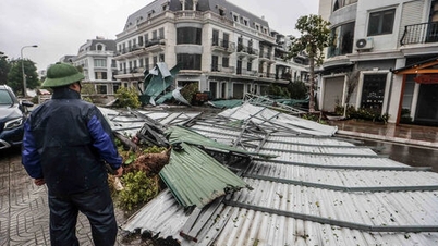
Natural disasters in September 2025 occurred fiercely and abnormally, with super typhoons appearing in the East Sea and many other dangerous weather patterns such as heat waves, widespread heavy rains... causing serious damage to people and property. According to information from the National Center for Hydro-Meteorological Forecasting, in September, 4 storms appeared in the East Sea: Storm No. 7 (TAPAH), Storm No. 8 (MITAG), Storm No. 9 (RAGASA) and Storm No. 10 (BUALOI). Notably, the appearance of super typhoon RAGASA entered the northeastern sea area of the North East Sea with the strongest wind near the center of the super typhoon reaching level 17, gusting above level 17 and maintaining this level for about 24 hours.
Although storm No. 10 (BUALOI) in the East Sea is not as strong as storm No. 9 (near the storm center, it is level 12, gusting to level 15), it makes landfall in the Ha Tinh - North Quang Tri area, the strongest wind near the storm center is level 11, gusting to level 14. Storm No. 10 and its circulation have been causing great damage to people and property.
Heavy rain also occurred in many areas, of which the Northern region from September 25 to 30 had widespread rain with total rainfall ranging from 100-250mm, especially the Southern region of Son La, Hoa Binh, Lao Cai, Yen Bai, Hanoi had total rainfall from 250-400mm, some places higher.
Notably, the heavy rain from September 26 to 30, due to the influence of storm No. 10, the Thanh Hoa-Nghe An area had a total rainfall of 450-600mm, some places over 600mm; the northern area of the South Central Coast had a total rainfall of 80-200mm, some places over 300mm. The total rainfall across the country was generally 30-70% higher than the average of many years, some places 70-120% higher; in particular, the northern mountainous area was 120-220% higher than the average of many years.
In September 2025, the North recorded a heat wave from September 5 to 8, with the highest daily temperature being 35-38 degrees Celsius. In the South, local heat waves appeared on September 5 with temperatures of 35-36 degrees Celsius.
Source: https://baotintuc.vn/van-de-quan-tam/du-bao-ngay-210-ap-thap-nhiet-doi-co-kha-nang-manh-len-thanh-bao-20251001154502976.htm
![[Photo] Prime Minister Pham Minh Chinh chairs a meeting of the Government Standing Committee to remove obstacles for projects.](https://vphoto.vietnam.vn/thumb/1200x675/vietnam/resource/IMAGE/2025/10/06/1759768638313_dsc-9023-jpg.webp)


Comment (0)