
The ship from Cambodia was traveling at six times the speed of the fishermen's boat, causing Lieutenant Nguyen Sy Tuan to not take his eyes off the radar screen.
On the night of August 2021, the ship entered the scanning range of Radar Station 625 of Regiment 551, Naval Region 5, located on Hon Doc Island (Ha Tien City, Kien Giang ). The night was dark and the sea was rough, but the ship was still moving at a speed of 19 nautical miles per hour. Mr. Tuan immediately reported to the commander on duty. A quick meeting of the on-duty crew concluded that the ship could be carrying smuggled goods or illegally crossing the border, because fishermen's fishing boats usually run 2-3 nautical miles per hour.
Lieutenant Tuan immediately informed the direction, distance, and sent the ship's image to the border guards in charge of inspection, and reported to the naval command post. The ship was captured by the ambush team at the Hon Chong Port Border Guard Station at 11:30 p.m. on August 14 in Kien Luong waters. The authorities later confirmed that the ship was smuggling cigarettes from Cambodia.
Detecting smuggling ships is just one of the tasks that the radar on Hon Doc Island performs when protecting the airspace and border waters.

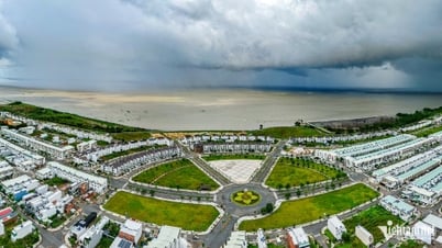
A corner of Hon Doc Island, January 2024. Photo: Hoang Phuong
Bordering Kep province of Cambodia, Hon Doc is 11 square kilometers wide and is the largest island in the Pirate Islands, where many important trade routes between the two countries are located. The sovereignty marker erected in 1958 is located on the west side of Hon Doc, clearly marking the names of the islands. Seafarers still call it Pirate Island because it was once attacked by pirates.
The Command of Naval Region 5 assessed: "Hon Doc has a strategic position in terms of national defense and security. Since the last century, this place has been identified as one of the key islands of the coastal island system in the Southwest sea." Therefore, about 20 years ago, Radar Station 625 was built on a high hill in Hon Doc.
Standing on the observation deck of Radar Station 625, one can clearly see some islands belonging to Kep province, located more than three nautical miles away. The radar waves become the "eyes" to observe all movements in the Ha Tien sea area, including smuggling and illegal fishing activities. Naval radar is like a target indication reconnaissance so that law enforcement forces at sea can grasp information and promptly handle arising situations.

Major Dinh Minh Suu has worked for 20 years at Radar Station 625 on Hon Doc Island. Photo: Hoang Phuong
After 30 years of observing radar screens, professional military major Dinh Minh Suu, head of radar station 625, has gained experience in identifying smuggling ships through some unusual signs of speed, direction, and time of operation. They often run at night at high speed, and do not dare to move as slowly as fishing boats for fear of being noticed by the coast guard.
The smuggled goods from Cambodia decades ago were precious woods, now they have been changed to consumer goods, such as sugar, cigarettes, gasoline, and tax-evading goods. Being strictly controlled, the smuggling groups sometimes disguise themselves as fishing boats or take advantage of the reeds and tree canopies along the island to avoid the radar of the navy.
Radar soldiers therefore have to stay alert when on duty, not taking their eyes off the screen even for a few minutes. Several people on duty take turns observing. High concentration becomes a challenge for new soldiers in the industry, while veterans easily get eye strain or joint pain from sitting in front of the screen for too long.
Stormy, thundery or the change of seasons at the end of the year with thick fog, sunny days with rising steam are the times when Major Suu's eyes are most tired. Observation range is hindered by the weather and can sometimes be reduced to half of normal. The mission at that time, in addition to using equipment, must also rely on the naked eye and observation experience to prevent unexpected events. After the rain, the sky is clear, the sea is calm, and everything is easy to see clearly.

Officers of Radar Station 625 on target observation duty, January 2024. Photo: Hoang Phuong
At 52 years old, Major Suu was part of the team that built the foundation for Radar Station 625 and has been there ever since. He remembers the day he first arrived, the island had no roads, there was only one boat trip a day, and he felt seasick and vomited bile.
Now there are electricity grids and water tanks. The hot corrugated iron roofs have been replaced by high-rise buildings. But the soldiers' duties remain the same, without a moment's distraction. Because the more bustling trade is, the more new types of crime appear.
"The task is more difficult, but the equipment is also more modern, I need to learn a lot to operate and keep up with the younger generation," he said with a smile. He also shared his professional experience with the young soldiers. He believes that loving the job is still the first priority, because only then can one stick with radar equipment for a long time.

A corner of Cambodia's island seen from the observation deck of Radar Station 625. Photo: Hoang Phuong
Senior Lieutenant Nguyen Tuan Anh, Head of Radar Station 625, said that before Tet, the unit focused on directions with the possibility of smuggling to monitor the situation, observe 24/7, and verify information about suspicious and irregular vessels. In addition to equipment, reconnaissance capabilities also rely on fishermen at sea to provide information.
The Southwest Sea covers an area of over 150,000 km2 and belongs to the two provinces of Kien Giang and Ca Mau. The sea has over 150 islands, 46 of which are inhabited, belonging to the archipelagos of An Thoi, Hai Tac, Ba Lua, Nam Du, and Tho Chu. The coastline is about 450 km long, from the mouth of the Ganh Hao River ( Bac Lieu ) to Ha Tien (Kien Giang).
The remaining sea areas include the historical waters of Vietnam - Cambodia with an area of about 16,000 km2, and the overlapping area of Vietnam - Malaysia with an area of about 2,800 km2. These sea areas have not been clearly defined in terms of sovereignty and sovereign rights, causing difficulties in management.
Hoang Phuong - Vnexpress.net
Source link![[Photo] Solemn opening of the 8th Congress of the Central Public Security Party Committee, term 2025-2030](https://vphoto.vietnam.vn/thumb/1200x675/vietnam/resource/IMAGE/2025/10/4/f3b00fb779f44979809441a4dac5c7df)


![[Photo] Bustling Mid-Autumn Festival at the Museum of Ethnology](https://vphoto.vietnam.vn/thumb/1200x675/vietnam/resource/IMAGE/2025/10/4/da8d5927734d4ca58e3eced14bc435a3)

![[Photo] General Secretary To Lam attends the 8th Congress of the Central Public Security Party Committee](https://vphoto.vietnam.vn/thumb/1200x675/vietnam/resource/IMAGE/2025/10/4/79fadf490f674dc483794f2d955f6045)


![[VIDEO] Summary of Petrovietnam's 50th Anniversary Ceremony](https://vphoto.vietnam.vn/thumb/402x226/vietnam/resource/IMAGE/2025/10/4/abe133bdb8114793a16d4fe3e5bd0f12)

![[VIDEO] GENERAL SECRETARY TO LAM AWARDS PETROVIETNAM 8 GOLDEN WORDS: "PIONEER - EXCELLENT - SUSTAINABLE - GLOBAL"](https://vphoto.vietnam.vn/thumb/402x226/vietnam/resource/IMAGE/2025/7/23/c2fdb48863e846cfa9fb8e6ea9cf44e7)


Comment (0)