
Mr. Hoang Phuc Lam, Deputy Director of the National Center for Hydro-Meteorological Forecasting, spoke to the press about the forecast and impacts of super typhoon RAGASA in the coming days:
Sir, according to forecast, when will super typhoon RAGASA enter the East Sea and what will its intensity be?
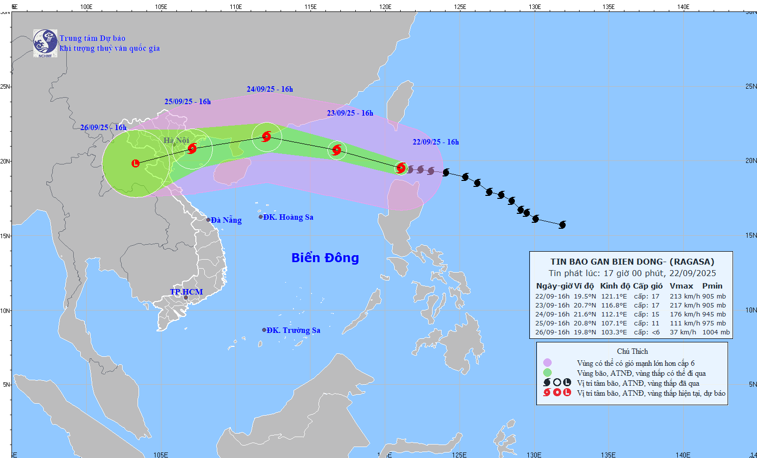
It is forecasted that on the night of September 22, storm RAGASA will enter the East Sea and become the 9th storm in 2025. It is likely that the storm will continue to maintain the intensity of level 17, which is the super storm level, when moving in the East Sea in the first 24 hours. After that, from around September 24, the storm may gradually weaken before making landfall in mainland China.
At present, while the storm is still in the Northwest Pacific , it is already stronger than storm number 3 in 2024. If on the night of September 22 when entering the East Sea, storm RAGASA continues to maintain its current intensity, it will be stronger than storm number 3 in 2024.
According to the scenario, which provinces and cities in Vietnam are at risk of being directly affected by this storm, sir?
The current forecast for typhoon RAGASA has two scenarios: The first is more likely to happen, the typhoon will head towards the mainland of Guangdong province, China. Then it will weaken and move towards the Gulf of Tonkin, entering the provinces of the Northeast region. The focus of impact according to this scenario will be the Northeast region and extend down to Thanh Hoa, Nghe An, Ha Tinh provinces.
The second option is that the storm may move lower, not make landfall in mainland China, and move mainly at sea. In that case, the intensity of storm RAGASA will be stronger than the first option and the danger level of the second option will be higher.
However, the first scenario forecast is more likely to happen, the storm will first make landfall in mainland China, move along the coast of mainland China down to the Gulf of Tonkin, causing strong winds and heavy rain in the northeastern provinces, provinces from Thanh Hoa to Ha Tinh from the night of September 24 to around September 27.
With waves over 10 meters high near the storm's eye from September 22, what preparations do the affected coastal provinces need to make to protect boats and maritime activities, sir?
Currently, the storm in the North East Sea area can reach a strong intensity, super storm level 16 - 17, so ships including large tonnage ships in the North East Sea area will also be sunk, very dangerous. As for the Gulf of Tonkin and coastal areas of the Northern and Central provinces, the storm warning can make landfall, maintaining an intensity of about level 10, above level 12, ships at sea also need to strictly comply with the instructions of local authorities on taking shelter before the storm arrives in the next one or two days.
Super typhoon RAGASA has a wider and more complex circulation, how does this affect the ability to forecast accurately, sir?
Storm RAGASA has a wide circulation and is one of the strongest storms in the East Sea. However, at the time of changing seasons, cold air masses begin to appear, although the intensity is not strong, but the impact of cold and dry air will make the intensity and trajectory of storm RAGASA complicated in the coming days.
With the forecast that from October to December 2025 there may be more than 4 more storms in the East Sea, higher than the average at the beginning of the year, do you have any advice for localities on upgrading the early warning and disaster response system, sir?
With current forecasts, there are still 4-5 more storms in the East Sea and about half of them will affect Vietnam's mainland. Therefore, the work of preventing and reviewing vulnerable points, building plans to respond to storms, especially in the provinces in the North and Central regions in the coming time still needs to be strictly implemented.
It is forecasted that in October and November, storms will continue to affect the central provinces of Vietnam and it is not excluded that there will be strong storms with complex developments. When combined with the cold air that is forecast to be active relatively early, it can cause heavy rain, flash floods, and landslides in the central region.
Thank you very much!
Source: https://baotintuc.vn/xa-hoi/sieu-bao-ragasa-co-cuong-do-manh-hon-bao-so-3-nam-2024-20250922181317979.htm
![[Photo] President Luong Cuong attends the 80th Anniversary of the Traditional Day of Vietnamese Lawyers](https://vphoto.vietnam.vn/thumb/1200x675/vietnam/resource/IMAGE/2025/10/09/1760026998213_ndo_br_1-jpg.webp)


![[Photo] General Secretary To Lam visits Kieng Sang Kindergarten and the classroom named after Uncle Ho](https://vphoto.vietnam.vn/thumb/1200x675/vietnam/resource/IMAGE/2025/10/09/1760023999336_vna-potal-tong-bi-thu-to-lam-tham-truong-mau-giao-kieng-sang-va-lop-hoc-mang-ten-bac-ho-8328675-277-jpg.webp)
![[Photo] Prime Minister Pham Minh Chinh chairs a meeting of the Government Standing Committee on overcoming the consequences of natural disasters after storm No. 11](https://vphoto.vietnam.vn/thumb/1200x675/vietnam/resource/IMAGE/2025/10/09/1759997894015_dsc-0591-jpg.webp)


Comment (0)