
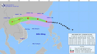
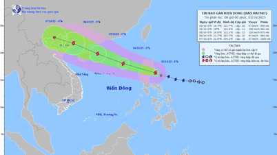
According to the Center for Hydro-Meteorological Forecasting, at 7:00 p.m. on September 21, the center of super typhoon RAGASA was at about 18.9°N - 125.4°E, about 350km east of Luzon Island (Philippines). The strongest wind near the center was level 16-17 (184-221km/h), gusting above level 17. The storm moved northwest at a speed of 15-20km/h.
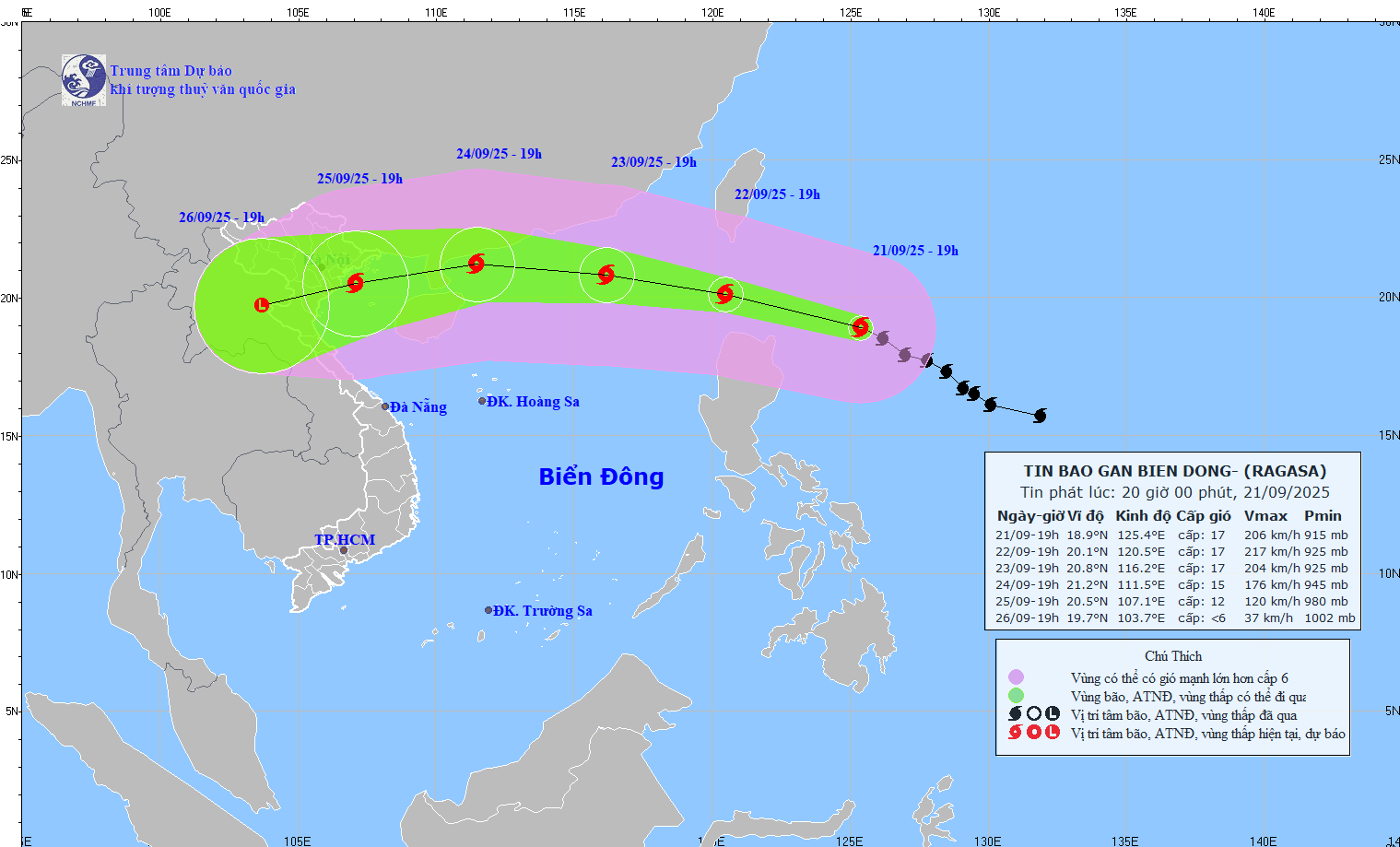
Forecasts for the next 72 hours show that the super storm will continue to maintain its very strong intensity as it approaches and enters the East Sea.
By 7 p.m. on September 22, the storm will be located about 120 km northwest of Luzon Island, maintaining a level 17 intensity, gusting above level 17. The risk of natural disasters in the northeastern sea area of the North East Sea is assessed at level 4.
By 7:00 p.m. on September 23, the storm moved deep into the northern East Sea, maintaining a level 16-17 intensity, gusting above level 17, continuing to pose a danger to ships and activities at sea.
By 7 p.m. on September 24, the super typhoon entered the coastal waters of Guangdong province (China), gradually weakening to level 14-15, gusting above level 17. Although there were signs of decreasing intensity, the risk of natural disasters for the North East Sea area remained at level 4 - a very high level.
During the next 72 to 120 hours, the storm is forecast to continue moving in a West-Southwest direction at a speed of about 20km/h and tend to weaken further, but is still an extremely dangerous weather form in the East Sea.
From September 22, the northeastern sea area of the East Sea will have winds gradually increasing to level 8-9, then increasing to level 10-14. The area near the center of the super typhoon will have winds of level 15-17, gusts above level 17, waves over 10.0m high, and very rough seas. Ships in the danger zone are likely to be affected by storms, whirlwinds, very strong winds, and very large waves.
Source: https://baolaocai.vn/sieu-bao-ragasa-tien-vao-bien-dong-gio-giat-tren-cap-17-post882631.html


![[Photo] Binh Trieu 1 Bridge has been completed, raised by 1.1m, and will open to traffic at the end of November.](https://vphoto.vietnam.vn/thumb/1200x675/vietnam/resource/IMAGE/2025/10/2/a6549e2a3b5848a1ba76a1ded6141fae)


![[Infographics] Biography of Central Party Committee Member, An Giang Provincial Party Secretary Nguyen Tien Hai](https://vphoto.vietnam.vn/thumb/402x226/vietnam/resource/IMAGE/2025/10/3/92491af6e2714aeb80cb1cdf831eb18a)


Comment (0)