
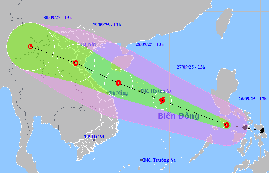
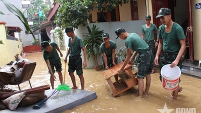
At 1:00 p.m. on September 26, the center of storm Bualoi was at about 12.5 degrees north latitude, 121.3 degrees east longitude, in the central Philippines with the strongest wind at level 11 (103-117 km/h), gusting to level 14.
Storm Bualoi is moving rapidly in the west-northwest direction at a speed of 35–40 km/h; then, moving into the East Sea and tending to strengthen.
At 1 p.m. on September 27, the center of storm Bualoi (storm No. 10) was at about 15.2 degrees north latitude, 114.2 degrees east longitude east of the five Hoang Sa special zones with the strongest wind at level 11-12, gusting to level 15. The storm continued to move west-northwest at a speed of 35km/h and continued to strengthen.
At 1:00 p.m. on September 28, the center of the storm was at about 17.1 degrees north latitude, 109.4 degrees east longitude in the offshore waters from Thanh Hoa to Quang Ngai with the strongest wind at level 13, gusting to level 16. The storm continued to move west-northwest at a speed of 25-30 km/h and continued to strengthen.
Due to the influence of the storm, from the evening of September 27, the sea area from Thanh Hoa - Quang Ngai (including Hon Ngu, Con Co, Ly Son islands) has winds gradually increasing to level 6-7, gusts 8-9, waves 3-5m high; from early morning of September 28, strong winds level 8-9, near the storm center level 10-13, gusts 16, waves 5-7m high, rough seas.
Vessels operating in dangerous areas are susceptible to storms, whirlwinds, strong winds and large waves.
Source: https://baodanang.vn/tu-chieu-toi-27-9-bao-bualoi-gay-gio-manh-tren-vung-bien-thanh-hoa-den-quang-ngai-3303716.html
![[Photo] Prime Minister Pham Minh Chinh chairs the Conference to deploy the National Target Program on Drug Prevention and Control until 2030](https://vphoto.vietnam.vn/thumb/1200x675/vietnam/resource/IMAGE/2025/10/09/1759990393779_dsc-0495-jpg.webp)

![[Photo] Prime Minister Pham Minh Chinh chairs a meeting of the Government Standing Committee on overcoming the consequences of natural disasters after storm No. 11](https://vphoto.vietnam.vn/thumb/1200x675/vietnam/resource/IMAGE/2025/10/09/1759997894015_dsc-0591-jpg.webp)


Comment (0)