

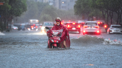
Flood risk map of urban areas in Long Xuyen, water level scenario on Hau River at Long Xuyen station reaches 265cm (15cm above alarm level III).
The peak tide of this period is likely to occur on October 8 to 10 (17 to 19 of the 8th lunar month). The highest water level on the Hau River at Long Xuyen is likely to be 20 - 30cm above alert level III; on Ong Chuong canal at Cho Moi is likely to be approximately at alert level III.
Flood warning area includes urban areas of Long Xuyen and Binh Duc wards and My Hoa Hung and Cho Moi communes. Flooding time: Morning (from 6am - 8am); afternoon (from 2pm - 3pm). Maximum flood depth is from 5 - 40cm. Disaster risk level on Hau River in Long Xuyen is level 2. Disaster risk level on Ong Chuong canal in Cho Moi is level 2.
Due to the impact of high tides in the lower reaches of the river combined with floods in the upper reaches of the Mekong River and heavy rain in the region, there is a possibility of flooding and local inundation in some low-lying areas, riverside areas, canals, roads and areas with low ground elevation, areas without dike systems, and weak culverts in the urban area in the two wards of Long Xuyen and Binh Duc and the two communes of My Hoa Hung and Cho Moi.
Source: https://baoangiang.com.vn/an-giang-canh-bao-lu-do-anh-huong-trieu-cuong-ram-thang-8-a463262.html


Comment (0)