
Forecast today, October 2, the tropical depression off the eastern coast of the Philippines is likely to strengthen into a storm and head towards the East Sea.
 |
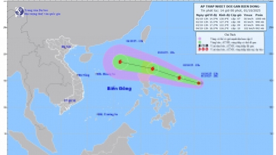
| Forecast of location and direction of tropical depression at 1am October 2 - Photo: VNDKS |
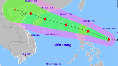
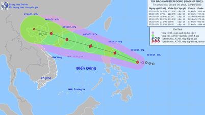
According to the National Center for Hydro-Meteorological Forecasting at 1am on October 2, the center of the tropical depression is located in the sea east of the Philippines. The strongest wind near the center of the tropical depression is level 7 (50-61km/h), gusting to level 9.
It is forecasted that during today and tonight, the tropical depression will move west-northwest at a speed of about 20km/h and is likely to strengthen into a storm.
At 1am tomorrow morning (October 3), the storm center will be in the sea east of Luzon Island, with storm intensity at level 8, gusting to level 10.
During tomorrow day and night, the storm will continue to move west-northwest at a speed of about 25km/h, entering the East Sea and is likely to strengthen. It is likely to be the 11th storm this year.
At 1:00 a.m. on October 4, the storm center was in the east of the North East Sea, the storm intensity was now level 9, gusting to level 11.
The National Center for Hydro-Meteorological Forecasting said that after entering the East Sea, the storm will move quite quickly at a speed of about 20-25km/h, towards Hainan Island (China) and its intensity is likely to increase.
The maximum intensity of the storm in the East Sea is forecast to reach level 11-12 (103-133km/h). After that, the storm is likely to enter the Gulf of Tonkin and affect our mainland.
In the immediate future, due to the influence of a tropical depression, possibly a storm, from the afternoon of October 3, the sea area east of the North East Sea will have winds gradually increasing to level 6-7, then increasing to level 8, the area near the storm center will have strong winds of level 9-10, gusting to level 12, waves 4-6m high. The sea is very rough.
During October 4-6, the North East Sea area (including Hoang Sa special zone) is likely to be affected by strong winds of level 11-12, gusting to level 15.
Vessels operating in the above mentioned dangerous areas are susceptible to the impact of storms, whirlwinds, strong winds and large waves.
According to tuoitre.vn
Source: https://baovinhlong.com.vn/thoi-su/202510/ap-thap-nhiet-doi-gan-bien-dong-kha-nang-manh-len-thanh-bao-hom-nay-fc503d2/


Comment (0)